
Arrival Date/到达日期:
21 February 2016/二零一六年二月二十一日
30 April 2016/二零一六年四月三十日
22 May 2016/二零一六年五月二十二日
29 January 2017/二零一七年一月二十九日
17 March 2018/二零一八年三月十七日
26 May 2018/二零一八年五月二十六日
8 February 2019/二零一九年二月八日
19 June 2022/二零二二年六月十九日
29 January 2023/二零二三年一月二十九日
26 November 2023/二零二三年十一月二十六日
29 September 2024/二零二四年九月二十九日
Destination/目的地:
Jenjarom(Sungai Jarom)/仁嘉隆:
 |
| Main Gateway of Jenjarom New Village/仁嘉隆新村主要入口 |
The Things Must Do:
1.Visiting the FGS Dong Zen Temple where is the famous Buddhist temple compounds.
2.Attending the FGS Dong Zen Temple Chinese New Year Lantern & Flora Festival.
3.Tasting the Hokkien Hong Bak.
4.Watching the Mah Meri woodcarvers' workshops of Carey Island.
5.Attending the Mah Meri Ancestral Day of Carey Island.
2.Attending the FGS Dong Zen Temple Chinese New Year Lantern & Flora Festival.
3.Tasting the Hokkien Hong Bak.
4.Watching the Mah Meri woodcarvers' workshops of Carey Island.
5.Attending the Mah Meri Ancestral Day of Carey Island.
仁嘉隆(另名为沟头/十四支)是坐落在巴生与直落邦里玛嘉朗/直落坡/直落街场(前名为十一支)附近德被誉为幸福村的其名字源自于嘉隆河(Sungai Jarom)意译为针河因这条支流长如针一样或一种名叫蒲草(Rumput Purun)的长针形叶子植物或中文名源自于马来地名Jenjarom 的福建话/闽南语发音Lin Ga Long 来命名的其华人社群以祖籍中国福建省南部的福建/闽南社群为多数的市镇,它以福建封肉闻名而从前则以咖啡、姜、韭菜与红茶/全发酵茶闻名。另外,马来西亚当地企业宝茶种植有限公司(Boh Plantations Sdn.Bhd.)的低地茶园紫丁山/茶山(前名为十六支)也坐落在这里附近因此此茶园不远处的名叫Serenia City/Bandar Serenia 的综合性发展区兼前茶园也以其茶树形状的马来西亚最大的活动雕塑/动态雕塑/动力雕塑/会移动的雕塑闻名。
一定要做的事:
1.参观著名佛寺群佛光山东禅寺。
2.出席佛光山东禅寺平安灯会暨花艺展。
3.品尝福建封肉。
4.观赏凯利岛玛美里族木雕师的工作室。
5.出席凯利岛的玛美里族祖先日。
2.出席佛光山东禅寺平安灯会暨花艺展。
3.品尝福建封肉。
4.观赏凯利岛玛美里族木雕师的工作室。
5.出席凯利岛的玛美里族祖先日。
Attractions in Jenjarom(Sungai Jarom)/仁嘉隆景点:
I.FGS Dong Zen Temple/佛光山东禅寺
I.FGS Dong Zen Temple/佛光山东禅寺
VIII.Mansion 1969/满园文创艺术馆
I)Amverton Cove Golf & Island Resort/安弗顿湾高尔夫球海岛度假村II)Mah Meri Cultural Village/玛美里族文化村
III)Samri Craft/Samri 手工艺术
IV)Tanjung Rhu Beach/丹绒鲁海滩
Government Clinics/政府诊所:
1.Jenjarom Health Clinic(Klinik Kesihatan)/仁嘉隆政府诊所
Google Map GPS Coordinate(approximately)/谷哥地图导览座标(估计性): 2.878417, 101.500694
2.Telok Panglima Garang Health Clinic(Klinik Kesihatan)/直落邦里玛嘉朗(直落坡/直落街场)政府诊所
Google Map GPS Coordinate(approximately)/谷哥地图导览座标(估计性): 2.904833, 101.467417
3.Sijangkang Health Clinic(Klinik Kesihatan)/昔江港政府诊所
Google Map GPS Coordinate(approximately)/谷哥地图导览座标(估计性): 2.941444, 101.456389
Attractions in Jenjarom(Sungai Jarom)/仁嘉隆景点:
I.FGS Dong Zen Temple/佛光山东禅寺:
I.FGS Dong Zen Temple/佛光山东禅寺:
 |
| FGS Dong Zen Temple/佛光山东禅寺 |
 |
| Meditation Hall/修持中心 |
 |
| Model of Longmen Grottoes/龙门石窟 |
 |
| F.G.S.Historical Gallery/宗史馆 |
 |
| Main Shrine/大雄宝殿 |
 |
| Main Shrine/大雄宝殿 |
 |
| Seven Jewels Pond/七宝池 |
 |
| Lumbini Garden/蓝毗尼园 |
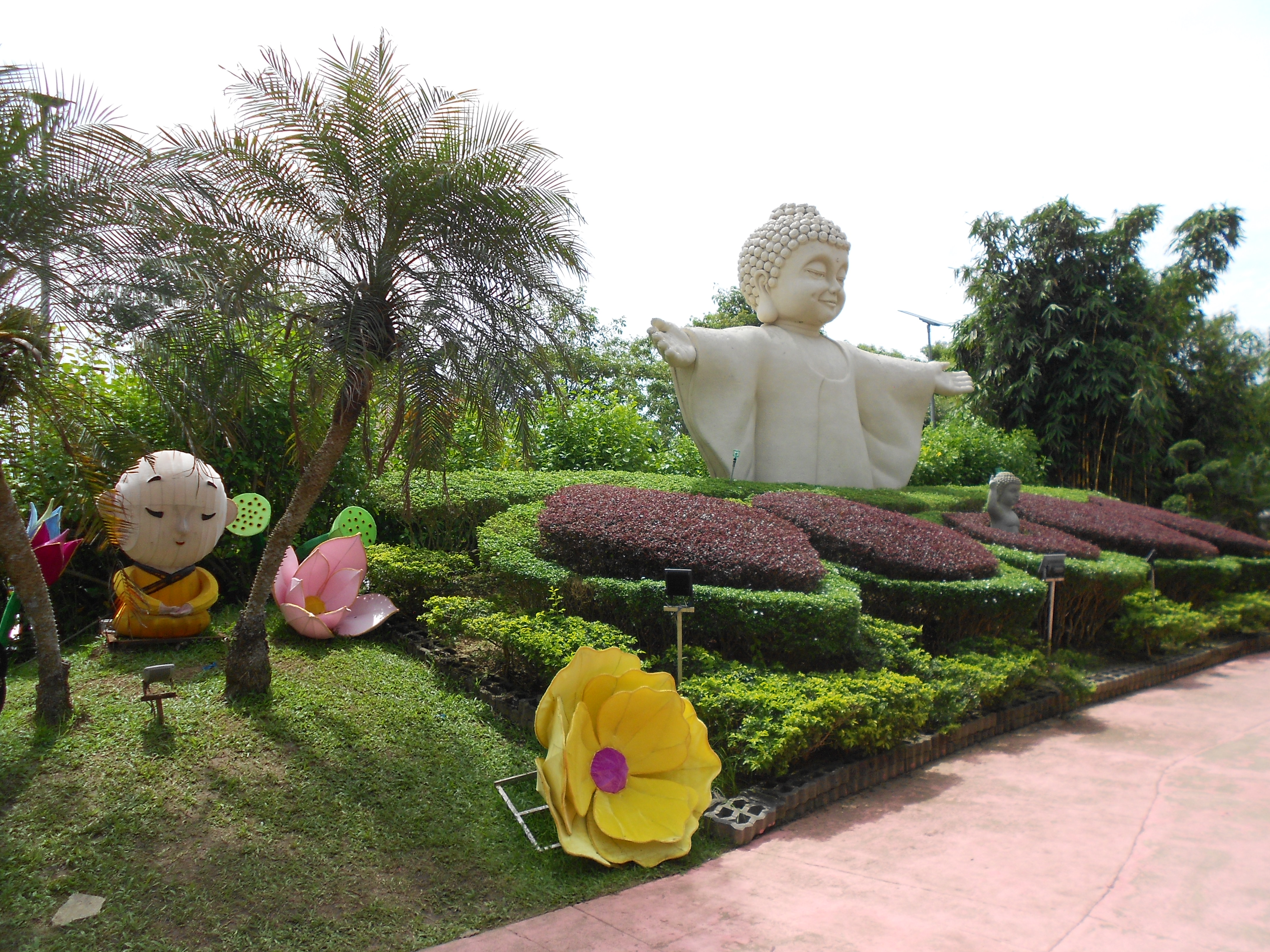
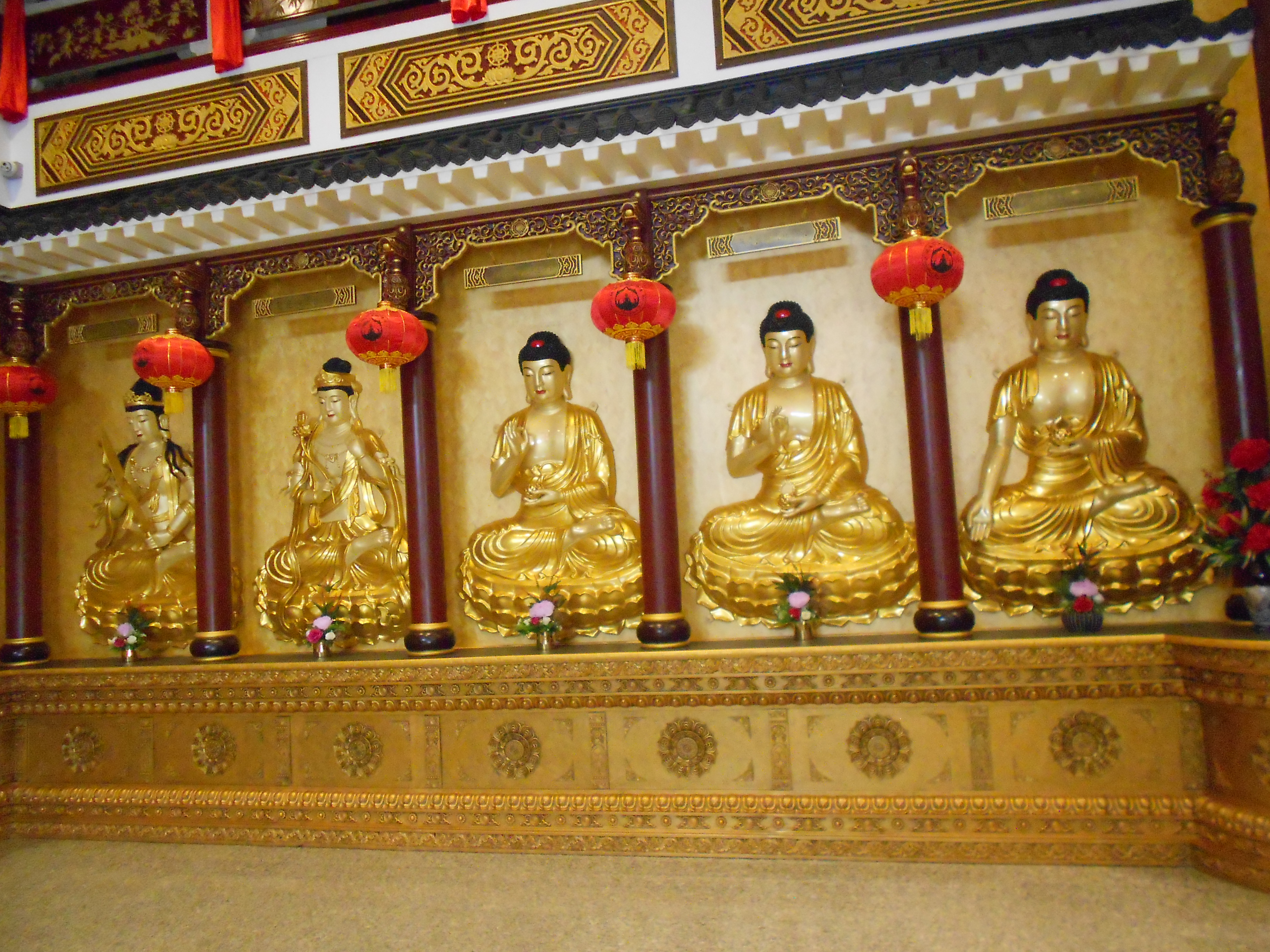
FGS Dong Zen Temple is the Buddhist temple branch of the famous international Buddhist organization called Fo Guang Shan(F.G.S.)(佛光山) where is also the largest Buddhist temple of Selangor that contains the largest bronze Buddha statue of Malaysia 18 feet high, the Buddha Relic that gifted from Supreme Patriarch of Thailand & the Lumbini Garden with Liuli Pagoda(琉璃宝塔)(now has been replaced by pavilion with Buddha statue), Seven Jewels Pond(七宝池), lotus pond, wishing bell & model of Spring Festival/Chinese New Year blessing Chinese Calligraphy of founder of Fo Guang Shan, late Venerable Hsing Yun(释星云) etc. The Buddhist temple is famous for its FGS Dong Zen Temple Chinese New Year Lantern & Flora Festival which is the lantern festival of Spring Festival/Chinese New Year that decorated with new and recycled light decorations by the volunteers, sometimes the light decorations of this lantern festival are also created the Malaysian Records like largest dog themed revolving lantern of Malaysia on 2018, tallest Leifeng Pagoda/Snake Pagoda(雷峰塔) themed lantern of Malaysia on 2025 and largest Mogao Caves(莫高窟) themed lantern of Malaysia on 2026 etc. Spring Festival/Chinese New Year which is the festival of different ethnic groups of China that marked the beginning of new year, celebrating the family reunion & praying for the blessing etc. on First Day of First Month of Chinese Lunar Calendar every year has been described as UNESCO Intangible Cultural Heritage of China. Buddhism is the religion that founded by Gautama Buddha/Shakyamuni Buddha with its main symbols are five coloured Buddhist flag & Dharma Wheel, its most iconic structure is the Mahabodhi Temple Complex of Bodh Gaya from India.
Attractions:
Attractions:
i.18 Arhats & Souvenir Shop
-the statues of Mahayana Buddhist deities whose has been attained the nirvana according to traditions.
ii.F.G.S.Historical Gallery
-the gallery that exhibiting the history of Fo Guang Shan & its founder, late Venerable Hsing Yun.
iii.Main Shrine
-the temple that dedicated to Lord Buddha/Sakyamuni/Shakyamuni Buddha.
iv.Chan/Zen Garden
-the mini Chinese & Japanese Chan/Zen concept landscaped garden.
v.Fo Guang Yuan Art Gallery,Sutra Calligraphy Hall & Relic Shrine
-the art gallery that exhibiting the temporary arts exhibitions & also enshrined the Buddha Relic.
vi.F.G.S.Education Centre
-the Buddhist educational college of FGS Dong Zen Temple.
vii.Model of Longmen Grottoes
-the replica model of the Longmen Grottoes of Luoyang of China.
viii.Meditation Hall
-the main activities centre & also event space of temple.
ix.Lumbini Garden
-the landscaped gardens that named after birthplace of Buddha in Nepal called Lumbini.
x.33 Avalokitesvara Bodhisattva Street
-the street that contains the 33 avatars statues of Buddhist Goddess of Mercy.
xi.Ten Great Disciples of Buddha
-the statues of Sariputta, Maudgalyayana, Mahākāśyapa & Subhuti etc.
xii.Main Theme Lantern Plaza
-the main themed light displays gardens of Chinese New Year Lantern & Flora Festival.
xiii.Deer Park
-the deer farm that built under the concept of Buddhist holy shrine in India called Sarnath.
xiv.Traquility Eco Farm
-the vegetables farm of the FGS Dong Zen Temple.
Arrival Date
21 February 2016
30 April 2016
29 January 2017
Arrival Date
21 February 2016
30 April 2016
29 January 2017
29 January 2023
*Maybe mistake in information.
Location
Sungai Buaya Road(Route B340)/Jalan Sungai Buaya
Google Map GPS Coordinate(approximately)
2.867783, 101.491462
Opening Hours
10am-6pm, Closed on Monday
Attention
1.Wearing in proper attire when visiting the main shrine.
2.Photography are not allowed inside the Fo Guang Yuan Art Gallery.
3.Do not acting any indecent behaviour inside the temple area.
4.Do not touch, climbing & sitting any exhibits items.
5.Pay attention of your children' altitudes.
Entrance Fee
Free
Website
www.fgs.org.my
佛光山东禅寺是拥有约十八英尺高的全马来西亚最大的铜佛佛像、泰国僧王所赠送的佛陀舍利以及含有琉璃宝塔(现已改为含有佛像的亭子)、七宝池、莲花池、许愿钟和佛光山创始人已故释星云法师春节/农历新年祝福书法模型等的蓝毗尼园的著名国际佛教组织佛光山的分院兼雪兰莪最大的佛寺。这间佛寺也以其春节/农历新年的由志工们用新与再循环花灯/灯笼来装饰的灯展佛光山东禅寺平安灯会暨花艺展闻名,有时候这项灯展的花灯/灯笼也创造出马来西亚纪录如二零一八年的马来西亚最大的狗主题旋转花灯/灯笼、二零二五年的马来西亚最高的雷峰塔/蛇年宝塔主题灯笼与二零二六年的马来西亚最大的莫高窟主题花灯/灯笼等。春节/农历新年是被列为中国的联合国教科文组织非物质文化遗产的每年正月初一标记着新一年的开始、家人团圆与祭祀祈福等的中国不同民族的节庆。佛教是由释迦牟尼/佛陀创立以五色佛教旗与法轮为主要标志的宗教,其最标志性的建筑物就是印度菩提伽耶的摩诃菩提寺。
景点:
i.十八罗汉像与流通处(纪念品店)
-根据大乘佛教的传统概念所描述的已经达到涅磐的神明的石像。
ii.宗史馆
-展览着佛光山与其创办人已故释星云法师的历史。
iii.大雄宝殿
-供奉着如来佛祖/释迦牟尼的佛寺。
iv.禅苑/枯山水
-以中国和日本禅式概念来建造的微型景观花园。
v.佛光缘美术馆、抄经堂与佛陀舍利殿
-展览着暂时性艺术展览同时也安置着佛祖舍利的艺术馆。
vi.东禅佛教学院
-佛光山东禅寺的佛教教育中心。
vii.龙门石窟
-中国洛阳龙门石窟的仿造模型。
viii.修持中心
-佛寺的活动中心兼节目空间。
ix.蓝毗尼园
-以尼泊尔的佛陀诞生地蓝毗尼来命名的景观花园。
x.三十三观音街
-拥有三十三尊佛教慈悲神明观世音菩萨的化身的石像的街道。
xi.十大弟子
-舍利弗、目犍连、大迦叶与须菩提等人物的塑像。
xii.主题灯广场
-平安灯会暨花艺展的主要主题灯光展示园区。
xiii.鹿苑
-以印度的佛教圣地鹿野苑为概念来建造的鹿园。
xiv.清净农场
-佛光山东禅寺的菜园。
到访日期
二零一六年二月二十一日
二零一六年四月三十日
二零一七年一月二十九日
二零二三年一月二十九日
*资讯可能有错误。
位置
双溪布雅亚路(B340号公路)/Jalan Sungai Buaya
谷哥地图导览座标(估计性)
开放时间
早上十点至傍晚六点,星期一休息
注意
(一)需端庄服饰才可进入大雄宝殿内。
(二)在佛光缘美术馆内禁止拍照。
(三)禁止在佛寺范围作出不雅行为。
(四)禁止触摸、爬骑与蹲坐任何展示品。
(五)请注意你的孩子的行为。
入门票
免费
网址
www.fgs.org.my
*资讯可能有错误。
位置
双溪布雅亚路(B340号公路)/Jalan Sungai Buaya
谷哥地图导览座标(估计性)
开放时间
早上十点至傍晚六点,星期一休息
注意
(一)需端庄服饰才可进入大雄宝殿内。
(二)在佛光缘美术馆内禁止拍照。
(三)禁止在佛寺范围作出不雅行为。
(四)禁止触摸、爬骑与蹲坐任何展示品。
(五)请注意你的孩子的行为。
入门票
免费
网址
www.fgs.org.my
Location Map/位置图:
II.Ban Siew Keng Temple/万寿宫:
 |
| Ban Siew Keng Temple/万寿宫 |
 |
| Ban Siew Keng Temple/万寿宫 |
 |
| Ban Siew Keng Temple/万寿宫 |
 |
| 12 Chinese Zodiac Animals/十二生肖 |
Ban Siew Keng Temple is the Chinese temple which is built under combination of four Chinese temples on 1965 and rebuilt on 2019 that dedicated to four main deities: Chinese God of Patrolling the Mortal called Lord Yu(余府大人/余攀龙), Chinese folk deity called Lord Wu De Ying Hou(武德英候/章府元帅/章侯), Chinese, Buddhist & Taoist Goddess of Mercy, Lord Avalokitesvara(观世音菩萨/观音大士/慈航真人/慈航大士) & Chinese God of War, one of Taoist Four Guardian General Gods(护法四帅) & 36 Heavenly Generals(三十六天将) & Buddhist Dharmapala called Lord Guan Di/Sangharama Bodhisattva/Guan Yu/Guan Yunchang(武圣关帝/伽蓝菩萨/关羽/关云长), the temple is also decorated with small peace lanterns of Lord Yu Images, wishing pond, 12 Chinese Zodiac Animals Statues & food court around the surroundings area of the temple, it is also comes crowded during the festive season of Chinese New Year/Spring Festival with its festival decorations. Guan Yu/Guan Yunchang is the general during the late East Han Dynasty(东汉末年) era of China who is loyalty & experienced in battle like he was helped the Imperial Chancellor & also powerful official of Eastern Han Dynasty, Cao Cao/Cao Mengde(曹操/曹孟德) after capturing by Cao Cao/Cao Mengde while he is defending city of his superior, Liu Bei/Liu Xuande(刘备/刘玄德) but Cao Cao/Cao Mengde let him to become his servant to defeat the army of warlord called Yuan Shao/Yuan Benchu(袁绍/袁本初) in the first battle during the Guandu Campaign/Battle of Guandu(官渡之战) called Battle of Boma/Battle of Baima(白马之战/白马之围/白马解围) let him awarded the title of Marquis of Hanshou Village(汉寿亭侯) by Emperor of Eastern Han Dynasty but in later he refused to loyalty to Cao Cao/Cao Mengde and returning to his original superior, Liu Bei/Liu Xuande and laid the foundation of later Shu Han/Ji Han(蜀汉/季汉) regime of Liu Bei/Liu Xuande of Three Kingdoms(三国) era so that he has been deified by Chinese Folk Belief, Taoism & Buddhism. The Goddess of Mercy/Avalokiteśvara's Birthdays is celebrated during the Nineteenth Day of Second Month(Birthday), Nineteenth Day of Sixth Month(Enlightment Day) & Nineteenth Day of Ninth Month(Nirvana Day) of Chinese Lunar Calendar. The Chinese temple architectural style is the temple that constructed based on Chinese philosophy called Feng Shui(风水) with the structure features like dougong/wooden bracket system(斗拱), curved roof & eaves etc.
Arrival Date
21 February 2016
8 February 2019
*Maybe mistake in information.
Malay Name
Persatuan Pengurusan Tokong Ban Siew Keng
Location
Sungai Buaya Road(Route B340)/Jalan Sungai Buaya
Google Map GPS Coordinate(approximately)
2.873311, 101.496310
Opening Hours
Unknown
Attention
Do not acting any indecent behaviour inside the temple area.
Entrance Fee
Free
Website
bansiewkeng.gbs2u.com
在一九六五年由四间华人庙宇合拼而成及在二零一九年重建的万寿宫是供奉着华人巡查凡间的神明余府大人/余攀龙、中国民间神明武德英候/章府元帅/章侯、华人民间信仰、佛教与道教慈悲神明观世音菩萨/观音大士/慈航真人/慈航大士与华人武圣兼道教护法四帅与三十六天将之一兼佛教护法神关帝/伽蓝菩萨/关羽/关云长四座神明的华人庙宇,这间庙宇也以小型余府大人的神像的平安灯、许愿池、十二生肖塑像和美食中心来装饰周围,它也在含有新春装饰的春节/农历新年节庆季节期间吸引人潮。关羽/关云长是中国东汉末年时期的忠义勇武的将军如他在守护其主公/领导的城池期间被东汉丞相兼权臣曹操/曹孟德生擒但曹操让他成为其部下在官渡之战期间的第一场战役白马之战/白马之围/白马解围打败军阀袁绍/袁本初的军队而被东汉皇帝册封为汉寿亭侯但后来他拒绝向曹操效忠而重回其原主刘备身边使后来为刘备在三国时期的蜀汉/季汉政权打下基础因此他也被华人民间信仰、道教与佛教神化。观音诞是在华人农历二月十九日(生日)、六月十九日(成道日)与九月十九日(涅槃日)期间庆祝。中式/汉式庙宇建筑风格是根据华人/汉人风水哲理来建造像斗栱/木制支架系统、曲线型屋顶与屋檐等建筑特色的庙宇。
到访日期
二零一六年二月二十一日
二零一九年二月八日
*资讯可能有错误。
马来名称
Persatuan Pengurusan Tokong Ban Siew Keng
位置
双溪布雅亚路(B340号公路)/Jalan Sungai Buaya
谷哥地图导览座标(估计性)
开放时间
不明确
注意
禁止在庙宇范围作出不雅行为。
入门票
免费
网址
bansiewkeng.gbs2u.com
Location Map/位置图:
III.Lu Guo An Fu Tang Gan Clan Association/鲁国颜氏安福堂:
 |
| Lu Guo An Fu Tang Gan Clan Association/鲁国颜氏安福堂 |
Arrival Date
29 January 2023
*Maybe mistake in information.
Malay Name
Persatuan Lu Guo Keturunan Gan An Fu Tang
Location
Location
2 Lane/Lorong 2,Kampung Baru Sungai Jarom
Google Map GPS Coordinate(approximately)
2.874301, 101.499040
Attention
Do not acting any indecent behaviour inside the temple area.
Entrance Fee
Free(Need permission to enter)
2.874301, 101.499040
Attention
Do not acting any indecent behaviour inside the temple area.
Entrance Fee
Free(Need permission to enter)
Website
它是由当地社团鲁国颜氏安福堂在一九七四年迁入仁嘉隆内建造的供奉着源自于中国山东省的含有三尊神像(坐像、坐着老虎的神像和老虎姿态的神像)的福建省乌土村(前名为紫泥乡)的颜氏保护神紫泥安福堂三圣尊王/赵公明的乌土村/紫泥乡的颜氏宗亲的祠堂。祠堂/家庙是以安置祖先神主牌来供奉姓氏宗族的被神化的祖先的华人庙宇。陈姓是其姓源自于曹姓或姬姓的小邾国的君主曹颜/邾武公或周公/周公旦之子伯禽的后裔的姓氏。
到访日期
二零二三年一月二十九日
*资讯可能有错误。
二零二三年一月二十九日
*资讯可能有错误。
马来名称
Persatuan Lu Guo Keturunan Gan An Fu Tang
位置
位置
仁嘉隆新村第二巷/Lorong 2,Kampung Baru Sungai Jarom
谷哥地图导览座标(估计性)
2.874301, 101.499040
注意
禁止在庙宇范围作出不雅行为。
入门票
免费(需获批准才能进入)
谷哥地图导览座标(估计性)
2.874301, 101.499040
注意
禁止在庙宇范围作出不雅行为。
入门票
免费(需获批准才能进入)
网址
Location Map/位置图:
IV.Si Zhi Tang/四知堂:
 |
| Si Zhi Tang/四知堂 |
Arrival Date
29 January 2023
*Maybe mistake in information.
Malay Name
Persatuan Yeoh Jenjarom Pantai Kelang Selangor
Location
Location
2 Lane/Lorong 2,Kampung Baru Sungai Jarom
Google Map GPS Coordinate(approximately)
2.874108, 101.499190
Attention
Do not acting any indecent behaviour inside the temple area.
Entrance Fee
Free(Need permission to enter)
2.874108, 101.499190
Attention
Do not acting any indecent behaviour inside the temple area.
Entrance Fee
Free(Need permission to enter)
这是还没在一九六三年迁入仁嘉隆期间名为圆通堂的供奉着外号为四知先生/关西孔子/关西夫子的中国东汉名臣杨震/杨伯起的杨氏宗亲的祠堂。祠堂/家庙是以安置祖先神主牌来供奉姓氏宗族的被神化的祖先的华人庙宇。杨姓是相信是源自于姬姓的中国春秋时期晋国的统治者晋武公之子杨伯侨的后裔的姓氏。
到访日期
二零二三年一月二十九日
*资讯可能有错误。
到访日期
二零二三年一月二十九日
*资讯可能有错误。
马来名称
Persatuan Yeoh Jenjarom Pantai Kelang Selangor
位置
位置
仁嘉隆新村第二巷/Lorong 2,Kampung Baru Sungai Jarom
谷哥地图导览座标(估计性)
2.874108, 101.499190
注意
禁止在庙宇范围作出不雅行为。
入门票
免费(需获批准才能进入)
Location Map/位置图:
V.Jenjarom Tung Loh Temple/仁嘉隆铜锣祖关帝庙(铜锣庙):
 |
| Jenjarom Tung Loh Temple/仁嘉隆铜锣祖关帝庙(铜锣庙) |
 |
| Jenjarom Tung Loh Temple/仁嘉隆铜锣祖关帝庙(铜锣庙) |
 |
| Jenjarom Tung Loh Temple/仁嘉隆铜锣祖关帝庙(铜锣庙) |
Jenjarom Tung Loh Temple is the Chinese temple where is dedicated to Chinese God of War, one of Taoist Four Guardian General Gods(护法四帅) & 36 Heavenly Generals(三十六天将) & Buddhist Dharmapala called Lord Guan Di/Sangharama Bodhisattva/Guan Yu/Guan Yunchang(武圣关帝/伽蓝菩萨/关羽/关云长) with three deity statues that founded on 1910 & moved to here on 2000, its Guan Di belief is originated from Causeway Temple of Bashe(八社铜锣庙) of Anxi(安溪) County of Quanzhou(泉州) Municipaity of Fujian Province of China. Guan Yu/Guan Yunchang is the general during the late East Han Dynasty(东汉末年) era of China who is loyalty & experienced in battle like he was helped the Imperial Chancellor & also powerful official of Eastern Han Dynasty, Cao Cao/Cao Mengde(曹操/曹孟德) after capturing by Cao Cao/Cao Mengde while he is defending city of his superior, Liu Bei/Liu Xuande(刘备/刘玄德) but Cao Cao/Cao Mengde let him to become his servant to defeat the army of warlord called Yuan Shao/Yuan Benchu(袁绍/袁本初) in the first battle during the Guandu Campaign/Battle of Guandu(官渡之战) called Battle of Boma/Battle of Baima(白马之战/白马之围/白马解围) let him awarded the title of Marquis of Hanshou Village(汉寿亭侯) by Emperor of Eastern Han Dynasty but in later he refused to loyalty to Cao Cao/Cao Mengde and returning to his original superior, Liu Bei/Liu Xuande and laid the foundation of later Shu Han/Ji Han(蜀汉/季汉) regime of Liu Bei/Liu Xuande of Three Kingdoms(三国) era so that he has been deified by Chinese Folk Belief, Taoism & Buddhism. The Chinese temple architectural style is the temple that constructed based on Chinese philosophy called Feng Shui(风水) with the structure features like dougong/wooden bracket system(斗拱), curved roof & eaves etc. Located near the temple is the Malaysian Chinese New Village/Kampung Baru(新村) themed homestay, Heritage-Stay(老厝民宿).
Arrival Date
29 January 2023
*Maybe mistake in information.
29 January 2023
*Maybe mistake in information.
Malay Name
Persatuan Penganut Dewa Tung Loh
Location
Location
1 Lane/Lorong 1,Kampung Baru Sungai Jarom
Google Map GPS Coordinate(approximately)
2.873958, 101.499963
2.873958, 101.499963
Opening Hours
Unknown
Attention
Do not acting any indecent behaviour inside the temple area.
Entrance Fee
Free
WebsiteDo not acting any indecent behaviour inside the temple area.
Entrance Fee
Free
仁嘉隆铜锣祖关帝庙(铜锣庙)是创立于一九一零年及在二零零零年迁入这里的供奉着含有三尊华人武圣兼道教护法四帅与三十六天将之一兼佛教护法神关帝/伽蓝菩萨/关羽/关云长的神像的华人庙宇,其关帝信仰源自于中国福建省泉州市安溪县的八社铜锣庙。关羽/关云长是中国东汉末年时期的忠义勇武的将军如他在守护其主公/领导的城池期间被东汉丞相兼权臣曹操/曹孟德生擒但曹操让他成为其部下在官渡之战期间的第一场战役白马之战/白马之围/白马解围打败军阀袁绍/袁本初的军队而被东汉皇帝册封为汉寿亭侯但后来他拒绝向曹操效忠而重回其原主刘备身边使后来为刘备在三国时期的蜀汉/季汉政权打下基础因此他也被华人民间信仰、道教与佛教神化。中式/汉式庙宇建筑风格是根据华人/汉人风水哲理来建造像斗栱/木制支架系统、曲线型屋顶与屋檐等建筑特色的庙宇。位于庙宇附近就是马来西亚华人新村主题民宿老厝民宿。
到访日期
二零二三年一月二十九日
*资讯可能有错误。
二零二三年一月二十九日
*资讯可能有错误。
马来名称
Persatuan Penganut Dewa Tung Loh
位置
仁嘉隆新村第一巷/Lorong 1,Kampung Baru Sungai Jarom
谷哥地图导览座标(估计性)
2.873958, 101.499963
谷哥地图导览座标(估计性)
2.873958, 101.499963
开放时间
不明确
注意
禁止在庙宇范围作出不雅行为。
入门票
免费
禁止在庙宇范围作出不雅行为。
入门票
免费
网址
Location Map/位置图:
VI.Pak Teh Kopitiam/郑叔叔咖啡店:
 |
| Pak Teh Kopitiam/郑叔叔咖啡店 |
 |
| Pak Teh Kopitiam/郑叔叔咖啡店 |
 |
| Pak Teh Kopitiam/郑叔叔咖啡店 |
It is the former traditional old house of Malaysian Chinese New Village/Kampung Baru has been turned into the cafe which is used recycle materials as decorations items that owned by local multi talented designer & also owner of another cafe in here called Mansion 1969(满园文创艺术馆), Mr.Pierre Teh Cheong Meng(郑兆洺/阿Teh/阿洺), it is also provided the vegetarian foods. Malaysian Chinese New Village/Kampung Baru(新村) is the Chinese village that formed during the Malayan Emergency era & the first cafe/coffee shop in the world is the Kiva Han from Constantinople(now known as Istanbul) of Türkiye/Turkey.
Arrival Date
29 January 2023
*Maybe mistake in information.
Location
1 Lane/Lorong 1,Kampung Baru Sungai Jarom
Google Map GPS Coordinate(approximately)
2.874175, 101.500532
Opening Hours
Wednesday-Monday: 7.30am-4pm
Closed on Tuesday
Attention
1.Do not touch, climbing & sitting any exhibits items.
2.Pay attention of your children' altitudes.
Entrance Fee
Free
1 Lane/Lorong 1,Kampung Baru Sungai Jarom
Google Map GPS Coordinate(approximately)
2.874175, 101.500532
Opening Hours
Wednesday-Monday: 7.30am-4pm
Closed on Tuesday
Attention
1.Do not touch, climbing & sitting any exhibits items.
2.Pay attention of your children' altitudes.
Entrance Fee
Free
这是现改为由多才多艺的当地设计师兼当地另一间咖啡厅满园文创艺术馆(Mansion 1969)的业主郑兆洺/阿Teh/阿洺先生所经营的使用环保物品来作为装饰品的咖啡厅的前马来西亚华人新村的老厝,它也提供素食美食。新村(Kampung Baru)是马来亚紧急状态时期形成的华人村庄以及全世界第一间咖啡厅/咖啡店是土耳其君士坦丁堡(现名为伊斯坦布尔)的Kiva Han。
到访日期
二零二三年一月二十九日
*资讯可能有错误。
位置
仁嘉隆新村第一巷/Lorong 1,Kampung Baru Sungai Jarom
谷哥地图导览座标(估计性)
开放时间
星期三至星期一: 早上七点半至下午四点
星期二休息
注意
(一)禁止触摸、爬骑与蹲坐任何展示品。
(二)请注意你的孩子的行为。
入门票
免费
到访日期
二零二三年一月二十九日
*资讯可能有错误。
位置
仁嘉隆新村第一巷/Lorong 1,Kampung Baru Sungai Jarom
谷哥地图导览座标(估计性)
开放时间
星期三至星期一: 早上七点半至下午四点
星期二休息
注意
(一)禁止触摸、爬骑与蹲坐任何展示品。
(二)请注意你的孩子的行为。
入门票
免费
Location Map/位置图:
VII.Mansion 1969/满园文创艺术馆:
It is the traditional house of Malaysian Chinese New Village/Kampung Baru where is also the former residence of local history professor, Dr.Ser Wue Hiong(徐威雄) has been transformed into the cafe with historical gallery for showing history of Selangor & Kuala Lumpur & also the orchard that founded by three owners including the Dr.Ser Wue Hiong, local multi talented designer who is also the owner of the another cafe in here called Pak Teh Kopitiam, Mr.Pierre Teh Cheong Meng(郑兆洺/阿Teh/阿洺) & founder of Anak Kulim Eatery & Gallery(小居林生活馆) of Kulim of Kedah(but this restaurant has been closed), Mr.Teh Deng Qi(郑登麒). Except for that, a vintage bus which is formerly to & from between the Klang & Banting has been transformed into the restaurant called Nightbus 127 Western Food Terminal is also operating during the night in here. Malaysian Chinese New Village/Kampung Baru(新村) is the Chinese village that formed during the Malayan Emergency era and the first bus of the world is invented by British inventors called late Mr.Walter Hancock & late Mr.Goldsworthy Gurney. The first cafe/coffee shop in the world is the Kiva Han from Constantinople(now known as Istanbul) of Türkiye/Turkey.
Arrival Date
21 February 2016
*Maybe mistake in information.
Location
Klang-Banting Road(Route 5)/Jalan Klang-Banting
Google Map GPS Coordinate(approximately)
2.891619, 101.482371
Opening Hours
Wednesday-Monday: 12pm-10pm
Closed on Tuesday
Opening Hours(Nightbus 127 Western Food Terminal)
Sunday-Thursday: 5pm-12am
Friday & Saturday: 5pm-1am
Closed on Tuesday
Attention
1.Do not touch, climbing & sitting any exhibits items.
2.Pay attention of your children' altitudes.
Entrance Fee
Free
这是由前身为本地历史教授徐威雄博士的故居的马来西亚华人新村的传统房屋转型为由包括徐威雄博士、也是这里另一间咖啡厅郑叔叔咖啡店(Pak Teh Kopitiam)的业主的多才多艺的当地设计师郑兆洺/阿Teh/阿洺先生以及也是现已关闭的吉打居林的餐厅小居林生活馆(Anak Kulim Eatery & Gallery)的业主郑登麒先生在内的三位经营者所创立的含有展示着雪兰莪及吉隆坡的历史的展览厅与果园的咖啡厅。除此之外,一间由从前来往巴生与万津之间的旧公车/巴士转型为餐馆的夜行巴士127 西餐总停站在晚上期间在这里营业。新村(Kampung Baru)是马来亚紧急状态时期形成的华人村庄以及全世界第一辆公共汽车/公车/巴士是由英国发明家已故沃尔特·汉考克(Walter Hancock)先生和已故金斯沃西·戈尼(Goldsworthy Gurney)先生所发明。全世界第一间咖啡厅/咖啡店是土耳其君士坦丁堡(现名为伊斯坦布尔)的Kiva Han。
到访日期
二零一六年二月二十一日
*资讯可能有错误。
位置
巴生-万津路(五号公路)/Jalan Klang-Banting
谷哥地图导览座标(估计性)
开放时间
星期三至星期一: 中午十二点至晚上十点
星期二休息
夜行巴士127 西餐总停站开放时间
星期日至星期四: 傍晚五点至凌晨十二点
星期五与星期六: 傍晚五点至凌晨一点
星期二休息
注意
(一)禁止触摸、爬骑与蹲坐任何展示品。
(二)请注意你的孩子的行为。
入门票
免费
 |
| Mansion 1969/满园文创艺术馆 |
 |
| Mansion 1969/满园文创艺术馆 |
 |
| Mansion 1969/满园文创艺术馆 |
Arrival Date
21 February 2016
*Maybe mistake in information.
Location
Klang-Banting Road(Route 5)/Jalan Klang-Banting
Google Map GPS Coordinate(approximately)
2.891619, 101.482371
Opening Hours
Wednesday-Monday: 12pm-10pm
Closed on Tuesday
Opening Hours(Nightbus 127 Western Food Terminal)
Sunday-Thursday: 5pm-12am
Friday & Saturday: 5pm-1am
Closed on Tuesday
Attention
1.Do not touch, climbing & sitting any exhibits items.
2.Pay attention of your children' altitudes.
Entrance Fee
Free
这是由前身为本地历史教授徐威雄博士的故居的马来西亚华人新村的传统房屋转型为由包括徐威雄博士、也是这里另一间咖啡厅郑叔叔咖啡店(Pak Teh Kopitiam)的业主的多才多艺的当地设计师郑兆洺/阿Teh/阿洺先生以及也是现已关闭的吉打居林的餐厅小居林生活馆(Anak Kulim Eatery & Gallery)的业主郑登麒先生在内的三位经营者所创立的含有展示着雪兰莪及吉隆坡的历史的展览厅与果园的咖啡厅。除此之外,一间由从前来往巴生与万津之间的旧公车/巴士转型为餐馆的夜行巴士127 西餐总停站在晚上期间在这里营业。新村(Kampung Baru)是马来亚紧急状态时期形成的华人村庄以及全世界第一辆公共汽车/公车/巴士是由英国发明家已故沃尔特·汉考克(Walter Hancock)先生和已故金斯沃西·戈尼(Goldsworthy Gurney)先生所发明。全世界第一间咖啡厅/咖啡店是土耳其君士坦丁堡(现名为伊斯坦布尔)的Kiva Han。
到访日期
二零一六年二月二十一日
*资讯可能有错误。
位置
巴生-万津路(五号公路)/Jalan Klang-Banting
谷哥地图导览座标(估计性)
开放时间
星期三至星期一: 中午十二点至晚上十点
星期二休息
夜行巴士127 西餐总停站开放时间
星期日至星期四: 傍晚五点至凌晨十二点
星期五与星期六: 傍晚五点至凌晨一点
星期二休息
注意
(一)禁止触摸、爬骑与蹲坐任何展示品。
(二)请注意你的孩子的行为。
入门票
免费
Location Map/位置图:
VIII.Sijangkang Mangrove Forest Recreational Park/昔江港红树林休闲公园:
It is the private mangrove forest park located near the honey bee farm of Sijangkang where is contains a pedestrian walkway for viewing the environment of mangrove forest & also provided barbeque facilities & jungle trekking activities. The Mangrove Forest is the coastal ecosystem that occurs in tropical region & subtropics region with mangrove trees whose are growth in the blackish water, it can protecting the coastal area from erosion, tsunami & storms. The wetland area is the ecosystem where can functioning as flood control, water purification & shoreline stabilization. Located not far from here is the Teluk Panglima Garang(also known as T.P.G.) where its name means the river bay of fierce warrior due to it is believed to be originated from several local legends such as warrior who is against the invaders in here called Panglima Hitam or local warrior who is killed the tiger that attacked the locals by solo etc. that contains the free trade zone.
Arrival Date
3 June 2017
*Maybe mistake in information.
Malay Name
Taman Rekreasi Paya Bakau Sijangkang
Location
Bersatu Road(Route B128)/Jalan Bersatu,Sijangkang,Telok Panglima Garang
Google Map GPS Coordinate(approximately)
2.940109, 101.422223
Opening Hours
Morning-7pm
Attention
1.Be quiet while walking the pathway.
2.Beware of poisonous snakes.
3.Do not feeding the animals.
4.Keeping the forest clean.
Entrance Fee
Below the RM5 per person
这是坐落在昔江港(前名为八支)的蜜蜂园旁的拥有一条可观赏红树林环境的行人步道以及提供烧烤设施以及森林徒步活动的私人红树林公园。红树林是在热带地区与亚热带/副热带地区出现由生长在黑色水域的红树组成的滨海生态系统,它可以保护滨海区逃离侵蚀、风暴与海啸。湿地区是可拥有洪水控制、净化水源与平衡海岸线用途的生态系统。位于这里不远处就是其名字在马来文意思为凶悍的勇士的河湾因为此名字相信是源自于如对抗这里的入侵者的勇士黑勇士(Panglima Hitam)或单独杀了袭击当地人的老虎的当地勇士等的多个当地传说而来的拥有自由贸易区的直落邦里玛嘉朗/直落坡/直落街场(前名为十一支)。
到访日期
二零一七年六月三日
*资讯可能有错误。
马来名称
Taman Rekreasi Paya Bakau Sijangkang
位置
直落邦里玛嘉朗(直落坡/直落街场)昔江港柏沙都路(B128 号公路)/Jalan Bersatu,Sijangkang,Telok Panglima Garang
谷哥地图导览座标(估计性)
开放时间
早上至晚上七点
注意
(一)行走步道时需安静。
(二)请小心毒蛇。
(三)请勿喂食动物。
(四)保持森林的清洁。
入门票
一个人马币低过五令吉
 |
| Sijangkang Mangrove Forest Recreational Park/昔江港红树林休闲公园 |
 |
| Sijangkang Mangrove Forest Recreational Park/昔江港红树林休闲公园 |
 |
| Sijangkang Mangrove Forest Recreational Park/昔江港红树林休闲公园 |
 |
| Sijangkang Mangrove Forest Recreational Park/昔江港红树林休闲公园 |
Arrival Date
3 June 2017
*Maybe mistake in information.
Malay Name
Taman Rekreasi Paya Bakau Sijangkang
Location
Bersatu Road(Route B128)/Jalan Bersatu,Sijangkang,Telok Panglima Garang
Google Map GPS Coordinate(approximately)
2.940109, 101.422223
Opening Hours
Morning-7pm
Attention
1.Be quiet while walking the pathway.
2.Beware of poisonous snakes.
3.Do not feeding the animals.
4.Keeping the forest clean.
Entrance Fee
Below the RM5 per person
这是坐落在昔江港(前名为八支)的蜜蜂园旁的拥有一条可观赏红树林环境的行人步道以及提供烧烤设施以及森林徒步活动的私人红树林公园。红树林是在热带地区与亚热带/副热带地区出现由生长在黑色水域的红树组成的滨海生态系统,它可以保护滨海区逃离侵蚀、风暴与海啸。湿地区是可拥有洪水控制、净化水源与平衡海岸线用途的生态系统。位于这里不远处就是其名字在马来文意思为凶悍的勇士的河湾因为此名字相信是源自于如对抗这里的入侵者的勇士黑勇士(Panglima Hitam)或单独杀了袭击当地人的老虎的当地勇士等的多个当地传说而来的拥有自由贸易区的直落邦里玛嘉朗/直落坡/直落街场(前名为十一支)。
到访日期
二零一七年六月三日
*资讯可能有错误。
马来名称
Taman Rekreasi Paya Bakau Sijangkang
位置
直落邦里玛嘉朗(直落坡/直落街场)昔江港柏沙都路(B128 号公路)/Jalan Bersatu,Sijangkang,Telok Panglima Garang
谷哥地图导览座标(估计性)
开放时间
早上至晚上七点
注意
(一)行走步道时需安静。
(二)请小心毒蛇。
(三)请勿喂食动物。
(四)保持森林的清洁。
入门票
一个人马币低过五令吉
Location Map/位置图:
IX.Carey Island/凯利岛:
凯利岛是位于马六甲海峡上以名为已故Valentine Carey 先生的英国种植家来命名的以其马来西亚半岛原住民社群的玛美里族(Mah Meri)部落的木雕师们的木雕闻名的岛屿,它也是被誉为马来西亚国家遗产活人物与二零二三年获得马来西亚手工艺术大师(Adiguru Kraf)的称号的本地原住民手艺编织家玛兹娜(Maznah Anak Unyan)师傅的出生地。
Attractions/景点:
Attractions/景点:
I)Amverton Cove Golf &
Island Resort/安弗顿湾高尔夫球海岛度假村:
 |
| Amverton Cove Golf & Island Resort/安弗顿湾高尔夫球海岛度假村 |
 |
| Golf Course/高尔夫球场 |
 |
| Animal Island/动物岛 |
 |
| Animal Island/动物岛 |
Amverton Cove Golf & Island Resort is the golf resort which is one of members of Malaysian Association of Themepark & Family Attractions(MATFA) that contains the accommodation facilities, golf course, water park, adventure park & animal park etc. The first amusement park in the world is the Dyrehavsbakken/Bakken located in the Copenhagen of Denmark and the modern golf games is originated from the Scotland of Great Britain.
Attractions:
i.Golf Course
-it is the golf course that surrounded by mangrove forest.
ii.Riverine Splash Water Theme Park
-the Mah Meri themed water park with wave pool, water slides & artificial river etc.
iii.Survival Park
-the park with maze garden, zipline/flying fox & obstacle course etc.
iv.Action Park
-the park which is provided the All Terrain Vehicle(A.T.V.)/Quadbike ride & go kart racing track etc.
v.Animal Island
-the islet with horse, birds, rabbits & lizard etc. that need to arrive by boat.
Arrival Date
30 April 2016
30 April 2016
*Maybe mistake in information.
Location
Carey Island Road/Jalan Pulau Carey,Carey Island
Google Map GPS Coordinate(approximately)
2.847194, 101.409417
Opening Hours(Riverine Splash Water Theme Park)
Monday-Thursday: 11am-5pm
Location
Carey Island Road/Jalan Pulau Carey,Carey Island
Google Map GPS Coordinate(approximately)
2.847194, 101.409417
Opening Hours(Riverine Splash Water Theme Park)
Monday-Thursday: 11am-5pm
Friday-Sunday & Holidays: 10am-6pm
Closed on Tuesday except Holidays
Opening Hours(Zipline/Flying Fox)
10am-6pm
Opening Hours(Kids A.T.V./Kids Quadbike)
Monday-Thursday: 10am-6pm
Friday-Sunday & Holidays: 9am-6pm
Opening Hours(All Terrain Vehicle(A.T.V.)/Quadbike Ride)
9am-1pm,2pm-6pm Opening Hours(Go Kart & Archery)
Monday-Thursday: 10am-5pm
Friday-Sunday & Holidays: 9am-6pm
Opening Hours(Animal Island) Monday-Friday: 10am-11.30am,3pm-4.30pm
Weekends: 10am-11.30am,4pm-5.30pm
Attention
1.Playing golf is need to reservation first.
1.Playing golf is need to reservation first.
2.Towels are not provided in the water park.
3.Paintball Shooting is limited for adults only.
Entrance Fee(Riverine Splash Water Theme Park)
Entrance Fee(Riverine Splash Water Theme Park)
From RM40 to RM70 per person
Child(height below 90cm): Free
Zipline/Flying Fox Fee
Above the RM40 per person
All Terrain Vehicle(A.T.V.)/Quadbike Ride Fee
Above the RM100 per person(Adult)
Above the RM40 per person(Kids)
Go Kart Ride Fee
Above the RM100 per person
Archery Fee
Above the RM30 per 12 arrows
Paintball Shooting Game Fee
Above the RM40 per person
Kayaking Fee
Above the RM30 per boat
Entrance Fee(Animal Island)
安弗顿湾高尔夫球海岛度假村是拥有住宿设施、高尔夫球场、水上乐园、探险乐园和动物公园等的同时也是马来西亚主题公园暨家庭娱乐协会(MATFA)成员之一的高尔夫球度假村。全世界第一间游乐园是丹麦哥本哈根的巴根游乐园以及现代高尔夫球游戏是源自于英国苏格兰。
景点:
i.高尔夫球场
-被红树林环绕着的高尔夫球场。
ii.Riverine Splash 水上乐园
-拥有波浪池、水上滑梯以及人造河等的玛美里族(Mah Meri)主题水上乐园。
-拥有波浪池、水上滑梯以及人造河等的玛美里族(Mah Meri)主题水上乐园。
iii.幸存者乐园
-拥有迷宫花园、溜索/飞狐活动和水上障碍挑战区等的公园。
iv.动作公园
-提供着全地形车/四轮摩托车以及卡丁车赛车跑道等的公园。
v.动物岛
-需船只到达的含有马、鸟类和蜥蜴等的小岛。
到访日期
二零一六年四月三十日
*资讯可能有错误。
位置
凯利岛凯利岛路/Jalan Pulau Carey,Carey Island
谷哥地图导览座标(估计性)
Riverine Splash 水上乐园开放时间
星期一至星期四: 早上十一点至傍晚五点
星期五至星期日与假期: 早上十点至傍晚六点
星期二休息除了假期
溜索/飞狐活动开放时间
早上十点至傍晚六点
儿童全地形车/四轮摩托车开放时间
星期一至星期四: 早上十点至傍晚六点
星期五至星期日与假期: 早上九点至傍晚六点
全地形车/四轮摩托车开放时间
早上九点至下午一点,下午两点至傍晚六点 卡丁车与射箭开放时间
星期一至星期四: 早上十点至傍晚五点
星期五至星期日与假期: 早上九点至傍晚六点
星期一至星期五: 早上十点至早上十一点半,下午三点至下午四点半
周末: 早上十点至早上十一点半,下午四点至傍晚五点半
注意
(一)需预订先才能打高尔夫球。
(二)水上乐园不提供面巾。
(一)需预订先才能打高尔夫球。
(二)水上乐园不提供面巾。
(三)弹漆球射击游戏只限于成人。
Riverine Splash 水上乐园入门票
一个人马币四十令吉至七十令吉之间
Riverine Splash 水上乐园入门票
一个人马币四十令吉至七十令吉之间
儿童(高度低过九十厘米): 免费
溜索/飞狐活动费
一个人马币高过四十令吉
全地形车/四轮摩托车乘坐费
一个人马币高过一百令吉(成人)
一个人马币高过四十令吉(儿童)
卡丁车乘坐费
一个人马币高过一百令吉
射箭费
十二支箭马币高过三十令吉
弹漆球射击游戏费
一个人马币高过四十令吉
划皮艇费
一艘皮艇马币高过三十令吉
动物岛入门票
Location Map/位置图:
II)Mah Meri Cultural Village/玛美里族文化村:
 |
| Mah Meri Cultural Village/玛美里族文化村 |
 |
| Mah Meri Cultural Village/玛美里族文化村 |
 |
| Mah Meri Cultural Village/玛美里族文化村 |
 |
| Mah Meri Cultural Village/玛美里族文化村 |
 |
| Mah Meri Cultural Village/玛美里族文化村 |
 |
| Mah Meri Cultural Village/玛美里族文化村 |
Arrival Date
21 February 2016
*Maybe mistake in information.
Malay Name
Kampung Kebudayaan Mah Meri
Location
Sungai Bumbun Aborigines Village Road/Jalan Kampung Orang Asli Sungai Bumbun,Carey Island
Google Map GPS Coordinate(approximately)
2.852056, 101.403768
Opening Hours
Only opened for appointment
Tel for appointment
011-65642800
Tel for appointment
011-65642800
Attention
1.Do not touch, climbing & sitting any exhibits items.
2.Pay attention of your children' altitudes.
Entrance Fee
www.mmcv.org.my
Website
www.mmcv.org.my
www.sgbumbun.net
这是坐落在玛美里族(Mah Meri)社群的木雕村双溪本奔村内展览着玛美里族社群的不同类型的祖先/祖灵(Moyang/Spirits)木雕面具与木雕雕塑如Moyang Harimau Berantai(在二零零二年获得联合国教科文组织手工艺品卓越认证奖项的拥有代表着生命延续的七个环与其嘴内代表着地球的球体与因陷阱被杀的一只老虎的故事相关的雕塑)、Moyang Pelandok、Moyang Sauh、Moyang Sempuar、Moyang Limbas、Moyang Buaya、Moyang Puting Beliong、Moyang Peneba、Moyang Belalang、Moyang Udang 及Moyang Galak 等、草环手工艺术(Origami)以及如被列为马来西亚非物质文化遗产的森林舞(Jo'oh/Mayin Jooh)的文化习俗等的微型博物馆。游客也可以通过穿上马美里族社群的传统服饰来拍照以体验此传统服饰以及在也售卖着玛美里木雕产品如Moyang Harimau Berantai 的纪念品店购买当地手工艺术品。位于文化村附近就是通常在春节/农历新年节庆季节后举办与巫师一同在祖先/祖灵屋内向祖先/祖灵(Moyang/Spirits)祈福的玛美里祭祖节(Alik Moyang)的主要举办地点。玛美里社群是居住在雪兰莪州瓜拉冷岳与雪邦滨海区以被列为马来西亚国家非物质文化遗产的木雕技术闻名的马来西亚半岛原住民其中一个部落以及马来西亚半岛原住民是包含了塞芒人、仙奴伊人与原始马来人三个主要部落的原住民群体社群。
到访日期
二零一六年二月二十一日
*资讯可能有错误。
马来名称
Kampung Kebudayaan Mah Meri
位置
凯利岛双溪本奔原住民村路/Jalan Kampung Orang Asli Sungai Bumbun,Carey Island
谷哥地图导览座标(估计性)
开放时间
只开放给预约者
预约拨电
011-65642800
预约拨电
011-65642800
Location Map/位置图:
III)Samri Craft/Samri 手工艺术:
 |
| Samri Craft/Samri 手工艺术 |
 |
| Samri Craft/Samri 手工艺术 |
 |
| Samri Craft/Samri 手工艺术 |
Arrival Date
30 April 2016
*Maybe mistake in information.
Malay Name
Samri Kraf
Location
Sungai Bumbun Aborigines Village Road/Jalan Kampung Orang Asli Sungai Bumbun,Carey Island
Google Map GPS Coordinate(approximately)
2.851220, 101.402162
Opening Hours
Unknown
Entrance Fee
Free
这是由在二零二一年被颁发马来西亚手工艺术大师(Adiguru Kraf)的名为Samri Abdul Rahman 师傅的当地木雕师所经营的双溪本奔村其中一间著名的玛美里族(Mah Meri)木雕师的工作坊。玛美里木雕师是以其雕刻祖先/祖灵(Moyang/Spirits)的塑像及面具闻名。玛美里社群是居住在雪兰莪州瓜拉冷岳与雪邦滨海区以被列为马来西亚国家非物质文化遗产的木雕技术闻名的马来西亚半岛原住民其中一个部落以及马来西亚半岛原住民是包含了塞芒人、仙奴伊人与原始马来人三个主要部落的原住民群体社群。
到访日期
二零一六年四月三十日
*资讯可能有错误。
马来名称
Samri Kraf
位置
凯利岛双溪本奔原住民村路/Jalan Kampung Orang Asli Sungai Bumbun,Carey Island
谷哥地图导览座标(估计性)
开放时间
不明确
入门费
免费
Location Map/位置图:
IV)Tanjung Rhu Beach/丹绒鲁海滩:
 |
| Tanjung Rhu Beach/丹绒鲁海滩 |
 |
| Tanjung Rhu Beach/丹绒鲁海滩 |
Arrival Date
21 February 2016
*Maybe mistake in information.
Malay Name
Pantai
Location
Carey Island Road/Jalan Pulau Carey,Carey Island
Google Map GPS Coordinate(approximately)
2.828597, 101.332865
Attention
1.Keeping the beach area clean.
2.Do not collect the marine resources like seashells & corals etc.
3.Do not soak in the water while you are applied the sunscreen lotion.
4.Do not bath with soap, body shampoo & shampoo in here.
Entrance Fee
Free
这是面向马六甲海峡的作为每年以当地巫师在低潮期间伴随着表演者们的舞蹈、音乐与歌唱在海上的祭坛上向祖先/祖灵们(Moyang/Spirits)祈福的玛美里族(Mah Meri)部落的祭海祖节庆(Puja Pantai)的主要举办地点的凯利岛的主要海滩,在海滩附近也有一个鱼贩摊位。玛美里社群是居住在雪兰莪州瓜拉冷岳与雪邦滨海区以被列为马来西亚国家非物质文化遗产的木雕技术闻名的马来西亚半岛原住民其中一个部落以及马来西亚半岛原住民是包含了塞芒人、仙奴伊人与原始马来人三个主要部落的原住民群体社群。海滩是一种由海浪带来这个地区的沙、砾石、鹅卵石与石头等形成的滨海地形。
到访日期
二零一六年二月二十一日
*资讯可能有错误。
马来名称
Pantai
位置
凯利岛凯利岛路/Jalan Pulau Carey,Carey Island
谷哥地图导览座标(估计性)
入门费
免费
Location Map/位置图:
The Tourist Attractions has been closed or current operating is unknown:
已关闭或目前经营乃不明确的旅游景点:
I.Jenjarom Cultural Centre/仁嘉隆文化馆:
It is the exhibition gallery, library, dim sum cafe & also headquarters of local organization called Jenjarom Cultural Association/Persatuan Kebudayaan Jenjarom(仁嘉隆幸福村工委会) where is the former residence of local teacher, late Mr.Gan Tim(颜显琛/颜琛) that displaying the photos about the history & culture of Jenjarom & also collecting the books from children books to encyclopedia even selling the Dim Sum, Pau/Baozi/Chinese Steamed Buns & local souvenirs. The first libraries in the world is believed to be came from ancient Sumer Civilization from Iraq.
Arrival Date
8 February 2019
这是前身为当地教师已故颜显琛/颜琛老师的故居的展览着仁嘉隆的历史与文化的照片还有收藏着从儿童书籍到百科全书的书籍甚至售卖点心、包子与当地纪念品的展览厅、图书馆、点心楼以及当地组织仁嘉隆幸福村工委会的总部。全世界第一群图书馆相信是源自伊拉克的古苏美尔文明。
Location Map/位置图:
Food around Jenjarom/仁嘉隆周围美食:
已关闭或目前经营乃不明确的旅游景点:
I.Jenjarom Cultural Centre/仁嘉隆文化馆:
 |
| Jenjarom Cultural Centre/仁嘉隆文化馆 |
 |
| Jenjarom Cultural Centre/仁嘉隆文化馆 |
 |
| Jenjarom Cultural Centre/仁嘉隆文化馆 |
Arrival Date
8 February 2019
29 January 2023
*Maybe mistake in information.
Malay Name
Persatuan Kebudayaan Jenjarom
Location
Sungai Buaya Road(Route B340)/Jalan Sungai Buaya
Google Map GPS Coordinate(approximately)
2.875253, 101.497863
*Maybe mistake in information.
Malay Name
Persatuan Kebudayaan Jenjarom
Location
Sungai Buaya Road(Route B340)/Jalan Sungai Buaya
Google Map GPS Coordinate(approximately)
2.875253, 101.497863
这是前身为当地教师已故颜显琛/颜琛老师的故居的展览着仁嘉隆的历史与文化的照片还有收藏着从儿童书籍到百科全书的书籍甚至售卖点心、包子与当地纪念品的展览厅、图书馆、点心楼以及当地组织仁嘉隆幸福村工委会的总部。全世界第一群图书馆相信是源自伊拉克的古苏美尔文明。
到访日期
二零一九年二月八日
二零一九年二月八日
二零二三年一月二十九日
*资讯可能有错误。
马来名称
Persatuan Kebudayaan Jenjarom
位置
双溪布雅亚路(B340号公路)/Jalan Sungai Buaya
谷哥地图导览座标(估计性)
*资讯可能有错误。
马来名称
Persatuan Kebudayaan Jenjarom
位置
双溪布雅亚路(B340号公路)/Jalan Sungai Buaya
谷哥地图导览座标(估计性)
Location Map/位置图:
Visitors can tasting the Hong Bak which is local improved version of Braised Pork Trotters(封肉) with more gravy(originally is fewer gravy and drier version) that originated from Fujian Province of China and made by cooking with black soysauce & spices etc. in the 新名古屋封肉, Yokofu Gourment Food & Ming Gu Wu Traditional Hong Bak Restaurant etc., the mushroom rice in the Heng Wong Jarom Restaurant which its owner is also selling banana fritters in another coffee shop during the night, Mee Hoon Kueh(面粉粿) which is the Hokkien/Minnan noodles that made with flour by hand torn with noodles soup version, dry version and curry soup version in the 飞板面(but not selling the Hakka noodles which is also made with dough called Pan Mee/板面/刀麻切), the garlic flavour deep fried dough sticks/youtiao/cakoi which is served sweet soups in the his own house with brand name called Jenjarom Yew Jia Geh Enterprise(仁嘉隆蒜味油炸粿) & buying the traditional Chinese candy that made from peanut & maltose called Hokkien/Fujian Peanut Candy/Kacang Tumbuk & Bean Candy/Kacang Pipang in the Heritaste Confectionery. Curry is the Indian dishes that combination of herbs & spices from India and Deep Fried Dough Sticks/Youtiao is the deep fried dough made Chinese food which is believed to be invented by the Wang Er(English translate)(王二) & Li Si(English translate)(李四) of Southern Song Dynasty(南宋) of China for protesting the Chancellor at that time, Qin Hui(秦桧) & his wife, Lady Wang(王氏) to murder the General Yue Fei(岳飞).
游客可品尝新名古屋封肉、有口福传统古早味封肉与名古屋传统封肉等的以黑酱油与香料等来熬煮而成的源自于中国福建的封肉的较多汤汁的本地改良版本福建封肉(原来为少汁与较干)、兴旺茶餐食的其业主在晚上期间在另一间咖啡店售卖炸香蕉的蘑菇饭、在不是售卖面团制造的客家面条板面/刀麻切的飞板面内以手撕面粉来制造的含有汤面版本、干拌/干捞版本与咖喱汤面版本的福建/闽南面食面粉粿、在其家里以仁嘉隆蒜味油炸粿品牌来命名的售卖着配搭糖水来吃的蒜味的油条以及在承记饼家买到由花生与麦芽糖制成的华人传统糖点福建贡糖与豆糖/花生糖。咖哩是以印度草本香料混合出来的印度佳肴而油条(另名为馃子/油炸鬼/油炸果)是相信由中国南宋的王二和李四用以抗议当时的丞相秦桧和其夫人王氏害死将军岳飞所发明的生面团制造的中式油炸食品。
新名古屋 Hokkien Hong Bak/Braised Pork Trotters
新名古屋福建封肉
Location/位置: Sekolah 1 Road/Jalan Sekolah 1,Kampung Baru Sungai Jarom,Jenjarom
Eggteen/Madam Ang's Eggcake Homemade Kuih Bahulu/Egg Cake
Eggteen/洪妈妈鸡蛋糕/尚口佳自制鸡蛋糕
Location/位置: Sekolah 1 Road/Jalan Sekolah 1,Kampung Baru Sungai Jarom,Jenjarom
Eggteen/洪妈妈鸡蛋糕/尚口佳自制鸡蛋糕
Location/位置: Sekolah 1 Road/Jalan Sekolah 1,Kampung Baru Sungai Jarom,Jenjarom
Heng Wong Jarom Mushroom Rice
兴旺蘑菇饭
Location/位置: Telok Ward Road/Jalan Telok Ward,Kampung Baru Sungai Jarom,Jenjarom

飞板面 Mee Hoon Kueh/Hokkien(Minnan) Hand Torn Noodles(Afternoon to Night)
飞板面面粉粿(下午至晚上)
Location/位置: 3 Lane/Lorong 3,Kampung Baru Sungai Jarom,Jenjarom
飞板面面粉粿(下午至晚上)
Location/位置: 3 Lane/Lorong 3,Kampung Baru Sungai Jarom,Jenjarom
Location Map/位置图:
Banana Fritters(Night)
炸香蕉(晚上)
Location/位置: 4 Lane/Lorong 4,Kampung Baru Sungai Jarom,Jenjarom

Jenjarom Yew Jia Geh Garlic Deep Fried Dough Sticks/Garlic Youtiao/Garlic Cakoi,Ham Chim Peng/Fried Cantonese Pastry,Red Bean Soup,Peanut Soup & Garlic Deep Fried Dough Sticks Pellets/Garlic Youtiao Pellets/Garlic Cakoi Pellets(Closed on Afternoon)
仁嘉隆蒜味油炸粿/蒜味油条、广式咸煎饼、红豆汤、豆仁汤/花生汤与蒜味油条粒(下午休息)
仁嘉隆蒜味油炸粿/蒜味油条、广式咸煎饼、红豆汤、豆仁汤/花生汤与蒜味油条粒(下午休息)
Location/位置: No.S-59,8 Lane/Lorong 8,Kampung Baru Sungai Jarom,Jenjarom
Google Map GPS Coordinate(approximately)/谷哥地图导览座标(估计性): 2.873293, 101.498615
Location Map/位置图:
Fu Guan Xiong Homemade Noodles Factory(Afternoon)
福源兴手工面厂(下午)
Location/位置: No.154,5 Lane/Lorong 5,Kampung Baru Sungai Jarom,Jenjarom
Google Map GPS Coordinate(approximately)/谷哥地图导览座标(估计性): 2.872472, 101.498500
福源兴手工面厂(下午)
Location/位置: No.154,5 Lane/Lorong 5,Kampung Baru Sungai Jarom,Jenjarom
Google Map GPS Coordinate(approximately)/谷哥地图导览座标(估计性): 2.872472, 101.498500

Yokofu Gourment Food Hokkien Hong Bak/Braised Pork Trotters(Closed on Afternoon)
有口福福建封肉(下午休息)
Location/位置: 8 Lane/Lorong 8,Kampung Baru Sungai Jarom,Jenjarom
*Back of Ban Siew Keng Temple
*万寿宫后面
有口福福建封肉(下午休息)
Location/位置: 8 Lane/Lorong 8,Kampung Baru Sungai Jarom,Jenjarom
*Back of Ban Siew Keng Temple
*万寿宫后面
Location Map/位置图:
仁嘉隆洪家手工包坊 Homemade Pau/Baozi/Chinese Steamed Buns
仁嘉隆洪家手工包坊手工包子
Location/位置: No.502,10 Lane/Lorong 10,Kampung Baru Sungai Jarom,Jenjarom
仁嘉隆洪家手工包坊手工包子
Location/位置: No.502,10 Lane/Lorong 10,Kampung Baru Sungai Jarom,Jenjarom

名古屋 Hokkien Hong Bak/Braised Pork Trotters(Located inside the 仁嘉隆天灵道堂)
名古屋福建封肉(位于仁嘉隆天灵道堂内)
Location/位置: Sungai Buaya Road/Jalan Sungai Buaya,Kampung Baru Sungai Jarom,Jenjarom
Location Map/位置图:

承记贡糖与豆糖/花生糖
Location/位置: Intan 2 Road/Jalan Intan 2,Taman Yayasan,Jenjarom
Location Map/位置图:
END
结束
Banting/万津:
 |
| Langat River/冷岳河 |
The Things Must Do:
1.Overlooking the river estuary of Langat River/Sungai Langat on the Jugra Hill.
2.Tasting the Sah Bak of Banting.
2.Tasting the Sah Bak of Banting.
3.Take a look the monument of Morib Beach for commemorating the historical event of World War II.
万津(另名为二十支)(别与坐落在砂拉越/沙捞越的龙芽内马来地名同名万丁的混淆)是其马来名字Banting 源自于爪哇野牛的马来名字Banteng 而来还有中文名字则是马来名字在闽南/福建方言的对音的其大多数华人社群为祖籍中国福建省南部福建/闽南社群的瓜拉冷岳县的县府兼瓜拉冷岳市议会(Majlis Perbandaran Kuala Langat)的地方政府所在地,万津也以刹肉/苦瓜猪杂汤闻名,它坐落在还没迁都至巴生前雪兰莪苏丹王朝的旧都城朱蛤附近,万津也是马来西亚著名羽毛球选手西迪(Sidek)兄弟们(米斯本·西迪(Misbun Sidek)先生、拉昔夫·西迪(Razif Sidek)先生、贾兰尼·西迪(Jalani Sidek)先生、拉曼·西迪(Rahman Sidek)先生和拉锡·西迪(Rashid Sidek)先生)的故乡因此游客在镇内可找到一座羽毛球雕塑。 另外,也是雪兰莪南部综合发展区的一部分的瓜拉冷岳县的名字是以冷岳河的河口来命名。
一定要做的事:
1.在蛤山瞭望冷岳河的河口。
2.品尝万津的刹肉。
3.观看摩立海滩的用以纪念第二世界大战期间的历史事件的纪念碑。
2.品尝万津的刹肉。
3.观看摩立海滩的用以纪念第二世界大战期间的历史事件的纪念碑。
Attractions in Banting/万津景点:
I.Nan Hai Guan Yin Sze Temple Banting/万津南海观音寺慈悲放生亭
I.Nan Hai Guan Yin Sze Temple Banting/万津南海观音寺慈悲放生亭
III.Jugra Hill/蛤山
VII.Morib Beach/摩立海滩
Government Clinics/政府诊所:
1.Teluk Datok Health Clinic(Klinik Kesihatan)/直落拿督政府诊所
Google Map GPS Coordinate(approximately)/谷哥地图导览座标(估计性): 2.819389, 101.517500
1.Teluk Datok Health Clinic(Klinik Kesihatan)/直落拿督政府诊所
Google Map GPS Coordinate(approximately)/谷哥地图导览座标(估计性): 2.819389, 101.517500
2.Kampung Bandar Health Clinic(Klinik Kesihatan)/甘榜班达政府诊所
Google Map GPS Coordinate(approximately)/谷哥地图导览座标(估计性): 2.851306, 101.444111
Google Map GPS Coordinate(approximately)/谷哥地图导览座标(估计性): 2.851306, 101.444111
Attractions in Banting/万津景点:
I.Nan Hai Guan Yin Sze Temple Banting/万津南海观音寺慈悲放生亭:
 |
| Nan Hai Guan Yin Sze Temple Banting/万津南海观音寺慈悲放生亭 |
 |
| Nan Hai Guan Yin Sze Temple Banting/万津南海观音寺慈悲放生亭 |
It is the Chinese temple & animals liberation site located near the Langat River/Sungai Langat where is dedicated to Chinese, Buddhist & Taoist Goddess of Mercy: Lord Avalokiteśvara(观世音菩萨/观音大士/慈航真人/慈航大士) with huge statues of Lord Avalokiteśvara, Chinese Goddess of Sea: Lord Mazu(妈祖/天后娘娘) & Buddhist God of Hell, Lord Ksitigarbha(地藏王菩萨). The Goddess of Mercy/Avalokiteśvara's Birthdays is celebrated during the Nineteenth Day of Second Month(Birthday), Nineteenth Day of Sixth Month(Enlightment Day) & Nineteenth Day of Ninth Month(Nirvana Day) of Chinese Lunar Calendar. The Chinese temple architectural style is the temple that constructed based on Chinese philosophy called Feng Shui(风水) with the structure features like dougong/wooden bracket system(斗拱), curved roof & eaves etc.
Arrival Date
29 January 2023
*Maybe mistake in information.
29 January 2023
*Maybe mistake in information.
Malay Name
Persatuan Penganut Dewa Nan Hai Guan Yin Sze Banting
Location
Location
Telok Bunut Road/Jalan Telok Bunut,Banting
Google Map GPS Coordinate(approximately)
2.833389, 101.516722
Opening Hours
Unknown
Attention
Do not acting any indecent behaviour inside the temple area.
Entrance Fee
Free
WebsiteDo not acting any indecent behaviour inside the temple area.
Entrance Fee
Free
这是坐落在冷岳河旁供奉着华人民间信仰、佛教兼道教慈悲神明观世音菩萨/观音大士/慈航真人/慈航大士同时也拥有观世音菩萨/观音大士/慈航真人/慈航大士、华人女海神妈祖/天后娘娘与佛教地府神明地藏王菩萨的巨型塑像的华人庙宇兼动物放生区。观音诞是在华人农历二月十九日(生日)、六月十九日(成道日)与九月十九日(涅槃日)期间庆祝。中式/汉式庙宇建筑风格是根据华人/汉人风水哲理来建造像斗栱/木制支架系统、曲线型屋顶与屋檐等建筑特色的庙宇。
到访日期
二零二三年一月二十九日
*资讯可能有错误。
二零二三年一月二十九日
*资讯可能有错误。
马来名称
Persatuan Penganut Dewa Nan Hai Guan Yin Sze Banting
位置
万津直落昆仑路/Jalan Telok Bunut,Banting
谷哥地图导览座标(估计性)
谷哥地图导览座标(估计性)
2.833389, 101.516722
开放时间
不明确
注意
禁止在庙宇范围作出不雅行为。
入门票
免费
网址 禁止在庙宇范围作出不雅行为。
入门票
免费
Location Map/位置图:
II.Sultan Abdul Samad Royal Mausoleum/苏丹阿都沙末皇陵:
 |
| Sultan Abdul Samad Royal Mausoleum/苏丹阿都沙末皇陵 |
Arrival Date
30 April 2016
*Maybe mistake in information.
Malay Name
Makam Diraja Sultan Abdul Samad
Location
Bukit Jugra Road(Route B124)/Jalan Bukit Jugra,Jugra
Google Map GPS Coordinate(approximately)
2.835519, 101.412448
Opening Hours
8am-5pm
Entrance Fee
Free
这是前雪兰莪苏丹已故苏丹阿都沙末(Sultan Abdul Samad)以及其他雪兰莪皇室成员的长眠之地。另外,吉隆坡的苏丹阿都沙末大厦/吉隆坡大钟楼以及苏丹阿都沙末占美清真寺是以殿下的名字来命名,殿下也是第一位荣誉英国的爵士勋章的雪兰莪苏丹,皇陵也是马来西亚国家遗产之一。雪兰莪苏丹王朝是由拉惹鲁姆/苏丹沙拉胡丁沙(Raja Lumu/Sultan Salahuddin Shah)在一七四五年所建立。
到访日期
二零一六年四月三十日
*资讯可能有错误。
马来名称
Makam Diraja Sultan Abdul Samad
位置
朱蛤蛤山路(B124号公路)/Jalan Bukit Jugra,Jugra
谷哥地图导览座标(估计性)
开放时间
早上八点至傍晚五点
入门票
免费
Location Map/位置图:
III.Jugra Hill/蛤山:
 |
| Jugra Hill/蛤山 |
 |
| River Estuary of Langat River(Sungai Langat)/冷岳河的河口 |
 |
| Paralidging/滑翔伞 |
Arrival Date
30 April 2016
*Maybe mistake in information.
Malay Name
Bukit Jugra
Location
Bukit Jugra Road(Route B124)/Jalan Bukit Jugra,Jugra
Google Map GPS Coordinate(approximately)
2.836060, 101.417235
Attention
Keeping the area clean.
Entrance Fee
Free
蛤山是因其山相似蛤而得名的可瞭望冷岳河河口、凯利岛与马六甲海峡的海拔约一百二十米高的含有灯塔以及望月台的山丘兼滑翔伞活动区。现代的滑翔伞是由美国的已故大卫·巴里斯(David Barish)先生所发明。全世界第一座灯塔相信是埃及亚历山大灯塔。另外,游客可在前往灯塔的路上看见位于华人坟场旁已被列为马来西亚国家遗产的前瓜拉冷岳县办公室的遗址还有附近的也是马来西亚国家遗产的前弹药库的遗址。
到访日期
二零一六年四月三十日
*资讯可能有错误。
马来名称
Bukit Jugra
位置
朱蛤蛤山路(B124号公路)/Jalan Bukit Jugra,Jugra
谷哥地图导览座标(估计性)
入门票
免费
Location Map/位置图:
IV.Jugra Insitu Museum/朱蛤地区博物馆:
 |
| Jugra Insitu Museum/朱蛤地区博物馆 |
 |
| Jugra Insitu Museum/朱蛤地区博物馆 |
 |
| Sugarcane Mill Stone/甘蔗磨石 |
Arrival Date
30 April 2016
*Maybe mistake in information.
Malay Name
Muzium Tapak Jugra
Location
Bukit Jugra Road(Route B124)/Jalan Bukit Jugra,Jugra
Google Map GPS Coordinate(approximately)
2.835519, 101.412448
Opening Hours
Saturday-Thursday: 9.30am-5.30pm
Friday: 9.30am-12pm,2.45pm-5.30pm
Closed on First Day & Second Day of Eid'l Fitr/Hari Raya Aidilfitri & First Day of Eidul Adha/Hari Raya Aidiladha
Attention
1.Photography are not allowed inside the museum.
2.Do not touch, climbing & sitting any exhibits items.
3.Pay attention of your children' altitudes.
Entrance Fee
Free
Website
www.padat.gov.my
朱蛤地区博物馆是坐落在朱蛤山的山脚下由建于一八七八年旧警察局兼监狱转型为用以展览着关于此建筑物、朱蛤、瓜拉冷岳县与雪兰莪州的历史如这里的考古活动和瓜拉冷岳县的历史古迹还有像陶瓷的与这间含有考古区的前警察局相关的历史文物的博物馆,它也拥有在考古活动发现的如水井和石阶等古迹,它也是马来西亚国家遗产之一。
到访日期
二零一六年四月三十日
*资讯可能有错误。
马来名称
Muzium Tapak Jugra
位置
朱蛤蛤山路(B124号公路)/Jalan Bukit Jugra,Jugra
谷哥地图导览座标(估计性)
开放时间
星期六至星期四: 早上九点半至傍晚五点半
星期五: 早上九点半至中午十二点,下午两点四十五分至傍晚五点半
开斋节的第一天与第二天以及古尔邦节/宰牲节的第一天休息
注意
(一)在博物馆内禁止拍照。
(二)禁止触摸、爬骑与蹲坐任何展示品。
(三)请注意你的孩子的行为。
入门票
免费
网址
www.padat.gov.my
Location Map/位置图:
V.Bandar Palace/班达皇宫:
 |
| Bandar Palace(Istana Bandar)/班达皇宫 |
Arrival Date
30 April 2016
*Maybe mistake in information.
30 April 2016
*Maybe mistake in information.
Malay Name
Istana Bandar
Location
Location
Old Palace Road(Route B125)/Jalan Istana Lama,Kampung Bandar,Jugra
Google Map GPS Coordinate(approximately)
2.859750, 101.441361
Opening Hours
Tuesday-Sunday: 9.30am-5.30pm
Friday: 9.30am-12.30pm,2.45pm-5.30pm
Last Admission: 4.30pm
Closed on Monday
Attention
1.Food & beverage are not allowed to bring inside the museum.
Google Map GPS Coordinate(approximately)
2.859750, 101.441361
Opening Hours
Tuesday-Sunday: 9.30am-5.30pm
Friday: 9.30am-12.30pm,2.45pm-5.30pm
Last Admission: 4.30pm
Closed on Monday
Attention
1.Food & beverage are not allowed to bring inside the museum.
2.Flash photography are not allowed inside the museum.
3.Do not touch, climbing & sitting any exhibits items.
4.Pay attention of your children' altitudes.
Entrance Fee
Free
3.Do not touch, climbing & sitting any exhibits items.
4.Pay attention of your children' altitudes.
Entrance Fee
Free
班达皇宫是被列为马来西亚国家遗产的在一八九九年使用正艾木与大理石以混合了印度式和中东式建筑风格来建造的雪兰莪苏丹的旧皇宫。现今,它已改为可让游客欣赏其建筑风格的博物馆。雪兰莪苏丹王朝是由拉惹鲁姆/苏丹沙拉胡丁沙(Raja Lumu/Sultan Salahuddin Shah)在一七四五年所建立。
到访日期
二零一六年四月三十日
*资讯可能有错误。
二零一六年四月三十日
*资讯可能有错误。
马来名称
Istana Bandar
位置
朱蛤甘榜班达旧皇宫路(B125号公路)/Jalan Istana Lama,Kampung Bandar,Jugra
谷哥地图导览座标(估计性)
开放时间
星期二至星期日: 早上九点半至傍晚五点半
星期五: 早上九点半至中午十二点半,下午两点四十五分至傍晚五点半
最后入场: 下午四点半
星期一休息
注意
(一)博物馆禁止携带饮食进入。
(二)博物馆禁止使用闪光灯拍照。
(三)禁止触摸、爬骑与蹲坐任何展示品。
(四)请注意你的孩子的行为。
入门票
免费
Istana Bandar
位置
朱蛤甘榜班达旧皇宫路(B125号公路)/Jalan Istana Lama,Kampung Bandar,Jugra
谷哥地图导览座标(估计性)
开放时间
星期二至星期日: 早上九点半至傍晚五点半
星期五: 早上九点半至中午十二点半,下午两点四十五分至傍晚五点半
最后入场: 下午四点半
星期一休息
注意
(一)博物馆禁止携带饮食进入。
(二)博物馆禁止使用闪光灯拍照。
(三)禁止触摸、爬骑与蹲坐任何展示品。
(四)请注意你的孩子的行为。
入门票
免费
Location Map/位置图:
VI.Sultan Ala'eddin Royal Mosque/阿拉乌丁皇家清真寺:
 |
| Sultan Ala'eddin Royal Mosque/阿拉乌丁皇家清真寺 |
Sultan Ala'eddin Royal Mosque is the royal mosque which its architecture design is believed to be originated from Deli Sultanate of Indonesia that built on 1925 under order of former Sultan of Selangor, late Sultan Alaeddin Sulaiman Shah has been described as National Heritage of Malaysia, it has been transformed from yellow colour to white colour during renovation. Islam is founded by Prophet Muhammad with main symbol is Star & Crescent, its main iconic structure is the Great Mosque of Mecca from Saudi Arabia.
Arrival Date
30 April 2016
*Maybe mistake in information.
Location
30 April 2016
*Maybe mistake in information.
Location
Old Palace Road(Route B125)/Jalan Istana Lama,Kampung Bandar,Jugra
Google Map GPS Coordinate(approximately)
2.863472, 101.440083
Opening Hours
Unknown
Attention
1.Take off the shoes before entering the mosque.
2.Female need to wear the robe before entering the mosque.
3.Wearing attire appropriately to enter the mosque.
4.Do not acting any indecent behaviour inside the mosque area.
Entrance Fee
Free(Non-Muslim need permission)
阿拉乌丁皇家清真寺是的由前雪兰莪苏丹已故苏丹阿拉丁苏莱曼沙(Sultan Alaeddin Sulaiman Shah)的号令下在一九二五年所建造的其建筑设计相信是源自于印尼的日里苏丹国的皇家清真寺,这间被列为马来西亚国家遗产的清真寺在修复期间从黄色改为白色。伊斯兰教是由先知穆罕默德/穆圣所创立以星月为主要标志的宗教,其最标志性的建筑物就是沙特阿拉伯/沙乌地阿拉伯/沙地阿拉伯麦加的禁寺。
到访日期
二零一六年四月三十日
*资讯可能有错误。
位置
朱蛤甘榜班达旧皇宫路(B125号公路)/Jalan Istana Lama,Kampung Bandar,Jugra
谷哥地图导览座标(估计性)
开放时间
不明确
注意
(一)进入清真寺前必须脱鞋。
(二)女性需要进入清真寺前穿上长袍。
(三)进入清真寺内需衣着端庄。
(四)禁止在清真寺范围作出不雅行为。
入门票
免费(非穆斯林需获批准)
Location Map/位置图:
VI.Morib Beach/摩立海滩:
It is the beach recreational area of Morib which is facing the Straits of Malacca that is also the landing site of British & Indian army whose participated in the Opeation Zipper on 9 September 1945 during World War II so that a monument for commemorating this historical event has been built up in here. The beach is the coastal landform that formed with the sands, gravel, pebble & rocks etc. that carried by the waves to the area.
Arrival Date
22 May 2016
*Maybe mistake in information.
Malay Name
Pantai Morib
Location
Route 5,Morib(pay attention for the signboards)
Google Map GPS Coordinate(approximately)
2.750808, 101.442855
Attention
1.Keeping the beach area clean.
2.Do not collect the marine resources like seashells & corals etc.
3.Do not soak in the water while you are applied the sunscreen lotion.
4.Do not bath with soap, body shampoo & shampoo in here.
Entrance Fee
Free
这是面向马六甲海峡的也是第二世界大战的一九四五年九月九日参与拉链行动英国与印度军队的登陆地点因此这里建立了一座用以纪念此历史事件的纪念碑的摩立(前名为毛立/毛立港/毛里/摩里/武猎)的海滩休闲区。海滩是一种由海浪带来这地区的沙、砾石、鹅卵石与石头等形成的滨海地形。
到访日期
二零一六年五月二十二日
*资讯可能有错误。
马来名称
Pantai Morib
位置
摩立五号公路(注意路牌)
谷哥地图导览座标(估计性)
入门票
免费
 |
| Morib Beach/摩立海滩 |
 |
| Morib Beach/摩立海滩 |
 |
| Morib Beach/摩立海滩 |
Arrival Date
22 May 2016
*Maybe mistake in information.
Malay Name
Pantai Morib
Location
Route 5,Morib(pay attention for the signboards)
Google Map GPS Coordinate(approximately)
2.750808, 101.442855
Attention
1.Keeping the beach area clean.
2.Do not collect the marine resources like seashells & corals etc.
3.Do not soak in the water while you are applied the sunscreen lotion.
4.Do not bath with soap, body shampoo & shampoo in here.
Entrance Fee
Free
这是面向马六甲海峡的也是第二世界大战的一九四五年九月九日参与拉链行动英国与印度军队的登陆地点因此这里建立了一座用以纪念此历史事件的纪念碑的摩立(前名为毛立/毛立港/毛里/摩里/武猎)的海滩休闲区。海滩是一种由海浪带来这地区的沙、砾石、鹅卵石与石头等形成的滨海地形。
到访日期
二零一六年五月二十二日
*资讯可能有错误。
马来名称
Pantai Morib
位置
摩立五号公路(注意路牌)
谷哥地图导览座标(估计性)
入门票
免费
Location Map/位置图:
Food around Banting/万津周围美食:
In the Banting, visitors can tasting the Sah Bak/Sah Bah(刹肉) of Sabafish Restaurant and Sha Ba Banting which is the pork offal soup with bitter gourd that can be served with Bah Kenn/Meatballs Broth(肉羹), the Bah Kenn is the broth which is made by cooking the meatballs along with local Malaysian Chinese herbal soup called Bak Kut Teh(肉骨茶), it is invented by the local called late Mr.Chen Po(English translate)(陈波). In the Jugra, visitors are need to taste the Beggar's Chicken of Bukit Jugra Beggar's Chicken Restaurant which is the chicken that stuffed with herbs & then wrapped in the clay & baked it slowly inside the charcoal ashes heap & it is originated from China by reservation first but this restaurant has been closed.
在万津,游客可品尝蛤山家乡刹肉以及万津老鼠刹肉的由当地人已故陈波先生所发明的可配搭使用马来西亚本地中药材汤肉骨茶的汤与肉丸一同熬煮出来的肉羹(福建话/闽南方言称为Bah Kenn)来吃的苦瓜猪杂汤刹肉(福建话/闽南方言称为Sah Bah)。在朱蛤,游客需以预订先才能品尝到丐帮名菜叫化餐厅的源自于中国的以把药材塞入鸡内后用泥土包裹然后将其放入炭灰堆内慢烘而成的叫化鸡/乞丐鸡但此餐厅现已关闭。
Jipun Fried Kuey Teow/Char Kuey Teow/Fried Rice Noodles
日本炒粿条/炒贵刁
Location/位置: Telok Bunut Road/Jalan Telok Bunut,Banting
明记亚东炒菇肉 Stir Fried Pork and Mushroom/Stir Fried Pork with Abalone Mushroom(Maple Oyster Mushroom)
明记亚东炒菇肉/炒猪肉配鲍鱼菇(盖囊菇/盖囊侧耳)
Location/位置: Beringin 4 Road/Jalan Beringin 4,Banting
明记亚东炒菇肉/炒猪肉配鲍鱼菇(盖囊菇/盖囊侧耳)
Location/位置: Beringin 4 Road/Jalan Beringin 4,Banting
Sabafish Sah Bak/Sah Bah/Sha Ba/Pork Offal Soup with Bitter Gourd
蛤山家乡刹肉/苦瓜猪杂汤
Location/位置: Bunga Pekan Road/Jalan Bunga Pekan,Banting
蛤山家乡刹肉/苦瓜猪杂汤
Location/位置: Bunga Pekan Road/Jalan Bunga Pekan,Banting

万津老鼠刹肉/苦瓜猪杂汤与肉羹/肉丸羹
Location/位置: Bunga Pekan 1 Road/Jalan Bunga Pekan 1,Banting
Location Map/位置图:

丐帮名菜叫化餐厅叫化鸡(已关闭)
Location/位置: Bukit Jugra Road(Route B124)/Jalan Bukit Jugra,Jugra
Location Map/位置图:
Markets around Banting/万津周围市场:
Banting Market
万津市场
Location/位置: Sentosa Road/Jalan Sentosa,Banting
END
结束
Tanjung Sepat/丹绒士拔:
 |
| Lover's Bridge/情人桥 |
The Things Must Do:
1.Walking along the Lover's Bridge.
2.Visiting the Ganofarm Mushroom Farm.
3.Visiting the Cunang Beach.
4.Learning about the swiftlets house in the Kuan Wellness Eco Park.
5.Visiting the Bagan Lalang Beach which is contains the palm shaped resort.
6.Buying some pitaya in the Sungai Pelek.
丹绒士拔是作为中药材海鲜汤海鲜肉骨茶的发源地的其名字是源自于三星毛足鲈的马来名字Sepat 而来的渔村。位于丹绒士拔不远处就是以火龙果/仙蜜果、含有由附近的吉隆坡国际机场建造期间形成的寸草不生的被抛弃的岩石区的火星基地(但这里需当地人导航才能参观及此地区非常难找到)以及由本地蝴蝶保育专家林明发先生所开含有咖啡厅的微型蝴蝶园“我的后花园”生态园闻名因此被誉为马来西亚的火龙果之乡与马来西亚第一座马来西亚华人新村蝴蝶生态旅游目的地的双溪比力(另名为雪邦五支),双溪比力从前以种植咖啡闻名。
一定要做的事:
1.在情人桥走一趟。
2.参观宝芝林蘑菇园。
3.参观珠浪海滩。
4.在官燕苑生态休闲农场了解燕屋。
5.参观含有棕榈树形状度假村的峇眼拉浪海滩。
6.在双溪比力购买一些火龙果。
Attractions in Tanjung Sepat/丹绒士拔景点:
I.Lover's Bridge/情人桥
I.Lover's Bridge/情人桥
VIII.Sepang River/雪邦河
Government Clinics/政府诊所:
1.Tanjung Sepat Health Clinic(Klinik Kesihatan)/丹绒士拔政府诊所
Google Map GPS Coordinate(approximately)/谷哥地图导览座标(估计性): 2.665639, 101.551528
2.Sungai Pelek Health Clinic(Klinik Kesihatan)/双溪比力政府诊所
Google Map GPS Coordinate(approximately)/谷哥地图导览座标(估计性): 2.644694, 101.718833
1.Tanjung Sepat Health Clinic(Klinik Kesihatan)/丹绒士拔政府诊所
Google Map GPS Coordinate(approximately)/谷哥地图导览座标(估计性): 2.665639, 101.551528
2.Sungai Pelek Health Clinic(Klinik Kesihatan)/双溪比力政府诊所
Google Map GPS Coordinate(approximately)/谷哥地图导览座标(估计性): 2.644694, 101.718833
Attractions in Tanjung Sepat/丹绒士拔景点:
I.Lover's Bridge/情人桥:
I.Lover's Bridge/情人桥:
 |
| Lover's Bridge/情人桥(Before Reconstruction/重建前) |
 |
| Lover's Bridge/情人桥(Before Reconstruction/重建前) |
 |
| Lover's Bridge/情人桥 |
 |
| Lover's Bridge/情人桥 |
 |
| Lover's Bridge/情人桥 |
 |
| Lover's Bridge Cultural Creativity Street/情人桥创意文化街 |
 |
| Lover's Bridge Cultural Creativity Street/情人桥创意文化街 |
 |
| Lover's Bridge Cultural Creativity Street/情人桥创意文化街 |
 |
| Lover's Bridge Cultural Creativity Street/情人桥创意文化街 |
 |
| Lover's Bridge Cultural Creativity Street/情人桥创意文化街 |
Arrival Date
22 May 2016
26 May 2018
*Maybe mistake in information.
Malay Name
Dataran Tanjung
Location
Senangin 1 Road/Jalan Senangin 1
Google Map GPS Coordinate(approximately)
2.657601, 101.556587
Attention
Keeping the area clean.
Entrance Fee
Free
这是约三百零六米长的前名为二号桥/第二桥头的已从木架步道改为含有一座名为红树林中的船的艺术品的混凝土步道的丹绒士拔面向马六甲海峡的渔船集中地点兼全马来西亚最长的情人桥,其名字相信是以同名的中文歌曲来命名。在情人桥附近就是小贩中心、用以祭祀附近已沉入大海中的华人坟场的先祖们的亡灵的华人神龛众姓庙、情人桥酱园土产海味商店及展览着旧物、艺术品与仿造的槟榔屿/槟城的乔治城/乔治市的壁画的情人桥创意文化街。
到访日期
二零一六年五月二十二日
二零一八年五月二十六日
*资讯可能有错误。
马来名称
Dataran Tanjung
位置
马友一号路/Jalan Senangin 1
谷哥地图导览座标(估计性)
入门票
免费
Dataran Tanjung
位置
马友一号路/Jalan Senangin 1
谷哥地图导览座标(估计性)
入门票
免费
Location Map/位置图:
II.Ganofarm Mushroom Farm/宝芝林蘑菇园:
 |
| Ganofarm Mushroom Farm/宝芝林蘑菇园 |
 |
| Ganofarm Mushroom Farm/宝芝林蘑菇园 |
 |
| Ganofarm Mushroom Farm/宝芝林蘑菇园 |
Arrival Date
22 May 2016
26 May 2018
*Maybe mistake in information.
Malay Name
Kilang Cendawan Ganofarm
Location
Laut Membiru Road/Jalan Laut Membiru,Taman Pelangi
Google Map GPS Coordinate(approximately)
2.658779, 101.553531
Opening Hours(Mushroom Farm)
9am-1pm
Attention
1.Must be booking in advance while visiting the mushroom farm.
2.Do not touch, climbing & sitting any exhibits items.
3.Pay attention of your children' altitudes.
Tel for appointment
603-31972393/019-2642480/019-6002482
Entrance Fee
Free
Entrance Fee(Mushroom Farm)
Below the RM20 per person(Minimum 5 persons)
Website
www.ganofarm.com
这间是出产灵芝、猴头菇、黑木耳与蚝菇等菇类及售卖着马来西亚特产与和蘑菇相关的产品的蘑菇园及民宿,游客也可在这里瞭望情人桥。蘑菇是一种拥有枝与顶的巨型真菌,它是英文名字Mushroom 相信是源自于法文 Mousseron。
到访日期
二零一六年五月二十二日
二零一八年五月二十六日
*资讯可能有错误。
马来名称
Kilang Cendawan Ganofarm
位置
彩虹花园蓝海路/Jalan Laut Membiru,Taman Pelangi
谷哥地图导览座标(估计性)
蘑菇园开放时间
早上九点至下午一点
注意
(一)参观蘑菇园需预约。
(二)禁止触摸、爬骑与蹲坐任何展示品。
(三)请注意你的孩子的行为。
预约
603-31972393/019-2642480/019-6002482
入门票
免费
蘑菇园入门票
一个人低过二十令吉(最低人数为五个人)
网址
www.ganofarm.com
Location Map/位置图:
III.Cunang Beach/珠浪海滩:
 |
| Cunang Beach/珠浪海滩 |
 |
| Cunang Beach/珠浪海滩 |
 |
| Cunang Beach/珠浪海滩 |
 |
| Cunang Beach/珠浪海滩 |
Arrival Date
22 May 2016
26 May 2018
*Maybe mistake in information.
Malay Name
Pantai Cunang
Location
Tepi Laut Road/Jalan Tepi Laut(pay attention for the signboards)
Google Map GPS Coordinate(approximately)
2.659401, 101.548446
Opening Hours
Unknown-8pm
Attention
1.Keeping the beach area clean.
2.Do not collect the marine resources like seashells & corals etc.
3.Do not soak in the water while you are applied the sunscreen lotion.
4.Do not bath with soap, body shampoo & shampoo in here.
Entrance Fee
Free
这是由玛美里原住民部落所美化的面向马六甲海峡的靠近红树林拥有屋舍与活动中心等的海滩休闲区。玛美里社群是居住在雪兰莪州瓜拉冷岳与雪邦滨海区以被列为马来西亚国家非物质文化遗产的木雕技术闻名的马来西亚半岛原住民其中一个部落以及马来西亚半岛原住民是包含了塞芒人、仙奴伊人与原始马来人三个主要部落的原住民群体社群。海滩是一种由海浪带来这个地区的沙、砾石、鹅卵石与石头等形成的滨海地形。
到访日期
二零一六年五月二十二日
二零一八年五月二十六日
*资讯可能有错误。
马来名称
Pantai Cunang
位置
海边路/Jalan Tepi Laut(注意路牌)
谷哥地图导览座标(估计性)
入门票
免费
Location Map/位置图:
IV.Liulishan Medicine Buddha Monastery/琉璃山药师佛寺:
 |
| Liulishan Medicine Buddha Monastery/琉璃山药师佛寺 |
 |
| Liulishan Medicine Buddha Monastery/琉璃山药师佛寺 |
 |
| Lord Medicine Buddha(Bhaisajyaguru) Shrine/药师佛殿 |
 |
| Liulishan Medicine Buddha Monastery/琉璃山药师佛寺 |
 |
| Liulishan Medicine Buddha Monastery/琉璃山药师佛寺 |
 |
| Liulishan Medicine Buddha Monastery/琉璃山药师佛寺 |
It is the only Buddhist God of Medicine, Lord Medicine Buddha/Bhaisajyaguru(药师佛) Buddhist temple of Malaysia which is founded by Chinese Taiwan Buddhist organization, Liulishan(琉璃山) that built in mixed architectural style of Tang Dynasty(唐朝) & Song Dynasty(宋朝) of China, it is the Buddhist temple about four levels with Lord Medicine Buddha/Bhaisajyaguru Shrine that enshrined the statue two faced Lord Medicine Buddha/Bhaisajyaguru & decorated with reliefs of Buddha deities, vegetarian food stall, souvenirs shop, farm, landscaped gardens, Chinese ancestral tablets hall, Twelve Heavely Generals(十二生肖大将/十二药叉大将)(12 Protector Gods/Yaksha of Lord Bhaisajyaguru) shrine, blessings shrine, drum tower, bell tower & main shrine. Located beside the temple is the accommodation facilities which is provided for devotees & backcpackers. Buddhism is the religion that founded by Gautama Buddha/Shakyamuni Buddha with its main symbols are five coloured Buddhist flag & Dharma Wheel, its most iconic structure is the Mahabodhi Temple Complex of Bodh Gaya from India.
Arrival Date
26 November 2023
*Maybe mistake in information.
Malay Name
Persatuan Buddhist Liulishan
Location
Tumbuk Sempadan Road/Jalan Tumbuk Sempadan(pay attention for the signboards)
Google Map GPS Coordinate(approximately)
2.662272, 101.597765
Opening Hours
Unknown
Attention
Do not acting any indecent behaviour inside the temple area.
Entrance Fee
Free
这间是由中国台湾佛教组织琉璃山所创立的混合了中国唐朝与宋朝建筑风格的全马来西亚唯一一间佛教医疗神药师佛的佛寺,它是约四层的拥有以佛教神明的浮雕来装饰的安置着双面的药师佛像的药师佛殿、素食摊位、纪念品店、农场、园艺花园、祖先神主牌殿、十二生肖大将/十二药叉大将(药师佛的十二位护法神)的神殿、祈福殿、鼓楼、钟楼以及大雄宝殿的佛寺。佛寺旁就是提供给信徒们与背包客们的住宿设施。佛教是由释迦牟尼/佛陀创立以五色佛教旗与法轮为主要标志的宗教,其最标志性的建筑物就是印度菩提伽耶的摩诃菩提寺。
到访日期
二零二三年十一月二十六日
*资讯可能有错误。
马来名称
Persatuan Buddhist Liulishan
位置
到访日期
二零二三年十一月二十六日
*资讯可能有错误。
马来名称
Persatuan Buddhist Liulishan
位置
冲破边界路/Jalan Tumbuk Sempadan(注意路牌)
谷哥地图导览座标(估计性)
开放时间
不明确
注意
禁止在佛寺范围作出不雅行为。
入门票
免费
谷哥地图导览座标(估计性)
开放时间
不明确
注意
禁止在佛寺范围作出不雅行为。
入门票
免费
Location Map/位置图:
V.Batu Laut Beach/峇都拉勿海滩:
 |
| Batu Laut Beach/峇都拉勿海滩 |
 |
| Batu Laut Beach/峇都拉勿海滩 |
 |
| Batu Laut Beach/峇都拉勿海滩 |
Arrival Date
26 November 2023
*Maybe mistake in information.
Malay Name
Pantai Batu Laut
Location
Route 5/Batu Laut
Google Map GPS Coordinate(approximately)
2.675464, 101.515178
Opening Hours
Unknown
Attention
1.Keeping the beach area clean.
2.Do not collect the marine resources like seashells & corals etc.
3.Do not soak in the water while you are applied the lotion.
4.Do not bath with soap, body shampoo & shampoo in here.
Entrance Fee
Free
这是以提供帆船活动训练的帆船活动协会闻名的面向马六甲海峡的海滩休闲区。海滩是一种由海浪带来这个地区的沙、砾石、鹅卵石与石头等形成的滨海地形。
到访日期
二零一六年五月二十二日
二零一八年五月二十六日
*资讯可能有错误。
马来名称
Pantai Batu Laut
位置
峇都拉勿五号公路/Batu Laut
谷哥地图导览座标(估计性)
入门票
免费
Location Map/位置图:
VI.Kuan Wellness Eco Park/官燕苑生态休闲农场:
The swiftlet house & swiftlet bird nest product centre that transformed into eco park that opened for public. The eco park also selling organic products & breeding animals as well as planting vegetables & fruits. Visitors can learning the informations about swiftlets & bird nest inside the theater of bird's house. Swiftlet bird nest which is mentioned in here is the Chinese favourite herbal dessert that made from bird nests that created by swallows with its saliva & its taste like jelly & its healing functions were founded during the journey of Chinese explorer & eunuch during Ming Dynasty(明朝), Admiral Zheng He/Cheng Ho(郑和) sailing team to the South East Asia.
Attractions:
i.Bird's Nest Gallery & Smoke-free Eco Cafe
ii.Antique Cars Gallery
iii.Bird's House
iv.Natural & Organic Pavilion
v.Local Farmer's Market
vi.Eco Farm
Arrival Date
22 May 2016
*Maybe mistake in information.
Location
Tanjung Layang Road/Jalan Tanjung Layang,Kampung Tanjung Layang(pay attention for the signboards)
Google Map GPS Coordinate(approximately)
2.693337, 101.496663
Opening Hours
Weekends & Public Holidays: 9am-7pm
Attention
1.Keeping the area clean.
2.Do not touch, climbing & sitting any exhibits items.
3.Pay attention of your children' altitudes.
Entrance Fee
Free
Entrance Fee(Bird's House)
Below the RM10 per person
Entrance Fee(Eco Farm)
Below the RM10 per person
Website
www.kuanwellnessecopark.com
这里是由燕屋与燕窝销售中心转变成开放让游客参观的生态农场。这座生态农场有售卖有机产品以及饲养动物和种植蔬果。游客可从燕屋内的影院了解关于燕子以及燕窝的资讯。燕窝是于中国明朝探索家与宦官郑和将军在他与其舰队成员到达东南亚时在他们寻找食物时所发现的华人传统养生补品,燕窝意译为一种由燕子(一种飞禽动物)的口液作制造的鸟窝。
景点:
i.燕子生态教育中心与无烟餐厅
ii.怀旧古董车
iii.燕屋
iv.天然有机馆
v.农村土产店
vi.生态农场
到访日期
二零一六年五月二十二日
*资讯可能有错误。
位置
丹绒拉央路/Jalan Tanjung Layang,Kampung Tanjung Layang(注意路牌)
谷哥地图导览座标(估计性)
开放时间
周末与公共假期: 早上九点至晚上七点
注意
(一)请保持地区的清洁。
(二)禁止触摸、爬骑与蹲坐任何展示品。
(三)请注意你的孩子的行为。
入门票
免费
燕屋入门票
一个人低过十令吉
生态农场入门票
一个人低过十令吉
网址
www.kuanwellnessecopark.com
 |
| Kuan Wellness Eco Park/官燕苑生态休闲农场 |
 |
| Eco Farm/生态农场 |
 |
| Natural & Organic Pavilion/天然有机馆 |
 |
| Interior of Bird's House/燕屋内观 |
 |
| Kuan Wellness Eco Park/官燕苑生态休闲农场 |
 |
| Kuan Wellness Eco Park/官燕苑生态休闲农场 |
Attractions:
i.Bird's Nest Gallery & Smoke-free Eco Cafe
ii.Antique Cars Gallery
iii.Bird's House
iv.Natural & Organic Pavilion
v.Local Farmer's Market
vi.Eco Farm
Arrival Date
22 May 2016
*Maybe mistake in information.
Location
Tanjung Layang Road/Jalan Tanjung Layang,Kampung Tanjung Layang(pay attention for the signboards)
Google Map GPS Coordinate(approximately)
2.693337, 101.496663
Opening Hours
Weekends & Public Holidays: 9am-7pm
Attention
1.Keeping the area clean.
2.Do not touch, climbing & sitting any exhibits items.
3.Pay attention of your children' altitudes.
Entrance Fee
Free
Entrance Fee(Bird's House)
Below the RM10 per person
Entrance Fee(Eco Farm)
Below the RM10 per person
Website
www.kuanwellnessecopark.com
这里是由燕屋与燕窝销售中心转变成开放让游客参观的生态农场。这座生态农场有售卖有机产品以及饲养动物和种植蔬果。游客可从燕屋内的影院了解关于燕子以及燕窝的资讯。燕窝是于中国明朝探索家与宦官郑和将军在他与其舰队成员到达东南亚时在他们寻找食物时所发现的华人传统养生补品,燕窝意译为一种由燕子(一种飞禽动物)的口液作制造的鸟窝。
景点:
i.燕子生态教育中心与无烟餐厅
ii.怀旧古董车
iii.燕屋
iv.天然有机馆
v.农村土产店
vi.生态农场
到访日期
二零一六年五月二十二日
*资讯可能有错误。
位置
丹绒拉央路/Jalan Tanjung Layang,Kampung Tanjung Layang(注意路牌)
谷哥地图导览座标(估计性)
开放时间
周末与公共假期: 早上九点至晚上七点
注意
(一)请保持地区的清洁。
(二)禁止触摸、爬骑与蹲坐任何展示品。
(三)请注意你的孩子的行为。
入门票
免费
燕屋入门票
一个人低过十令吉
生态农场入门票
一个人低过十令吉
网址
www.kuanwellnessecopark.com
Location Map/位置图:
VII.Sepang Gold Coast(Bagan Lalang Beach)/雪邦黄金海岸(峇眼拉浪海滩):
 |
| Bagan Lalang Beach/峇眼拉浪海滩 |
 |
| Bagan Lalang Beach/峇眼拉浪海滩 |
Arrival Date
22 May 2016
*Maybe mistake in information.
Malay Name
Pantai Bagan Lalang
Location
Bagan Lalang(pay attention for the signboards)
Google Map GPS Coordinate(approximately)
2.600175, 101.689460
Attention
1.Keeping the beach area clean.
2.Do not collect the marine resources like seashells & corals etc.
3.Do not soak in the water while you are applied the sunscreen lotion.
4.Do not bath with soap, body shampoo & shampoo in here.
Entrance Fee
Free
这是面向马六甲海峡拥有一间貌似棕榈树形状也是马来西亚主题公园暨家庭娱乐协会(MATFA)成员之一名为AVANI 雪邦黄金海岸的度假村的海滩休闲区。海滩是一种由海浪带来这个地区的沙、砾石、鹅卵石与石头等形成的滨海地形。
到访日期
二零一六年五月二十二日
*资讯可能有错误。
马来名称
Pantai Bagan Lalang
位置
峇眼拉浪/Bagan Lalang(注意路牌)
谷哥地图导览座标(估计性)
入门票
免费
Location Map/位置图:
VIII.Sepang River/雪邦河:
 |
| Sepang River/雪邦河 |
 |
| Sepang River/雪邦河 |
 |
| Sepang River/雪邦河 |
 |
| Sepang River/雪邦河 |
Sepang River/Sungai Sepang is the river which is marked the state border of Selangor State & Negeri Sembilan State that contains the mangrove forest, river raft houses & fishing jetties etc., it can watching the mudskippers, crabs, macaques & monitor lizards etc., some fishing jetties is also provided fishing boat services, river cruise & kayaking etc.
Arrival Date
29 September 2024
29 September 2024
*Maybe mistake in information.
Malay Name
Sungai Sepang
Location
Sepang River/Sungai Sepang
Google Map GPS Coordinate(approximately)
Malay Name
Sungai Sepang
Location
Sepang River/Sungai Sepang
Google Map GPS Coordinate(approximately)
2.622944, 101.729389(Pak Lim Jetty)
2.608389, 101.702694(Sirip Biru Jetty)
Opening Hours
According to different fishing jetties
Attention
Keeping the river clean.
Entrance Fee
Keeping the river clean.
Entrance Fee
According to different fishing jetties
雪邦河是用以标记着森美兰州与雪兰莪州州界的拥有红树林、竹筏屋以及钓鱼码头等的河流,这里可看见弹涂鱼、螃蟹、猕猴和巨蜥等,一些码头也提供钓鱼船服务、游河船以及划皮艇等。
到访日期
二零二四年九月二十九日
*资讯可能有错误。
马来名称
Sungai Sepang
位置
雪邦河/Sungai Sepang
谷哥地图导览座标(估计性)
入门票
根据各自码头而定
二零二四年九月二十九日
*资讯可能有错误。
马来名称
Sungai Sepang
位置
雪邦河/Sungai Sepang
谷哥地图导览座标(估计性)
入门票
根据各自码头而定
Location Map/位置图(Pak Lim Jetty & Sirip Biru Jetty/Pak Lim 码头与Sirip Biru 码头):
IX.H.L.Dragon Fruit Eco Farm/H.L.火龙果生态园:
 |
| H.L.Dragon Fruit Eco Farm/H.L.火龙果生态园 |
 |
| H.L.Dragon Fruit Eco Farm/H.L.火龙果生态园 |
 |
| H.L.Dragon Fruit Eco Farm/H.L.火龙果生态园 |
 |
| H.L.Dragon Fruit Eco Farm/H.L.火龙果生态园 |
 | |
| Largest Pitaya shaped like Building of Malaysia/马来西亚最大的相似火龙果的建筑物 |
 |
| Airplane(Aeroplane)/飞机 |
 |
| H.L.Dragon Fruit Eco Farm/H.L.火龙果生态园 |
It is the pitaya farm where is opened by the local Malaysian entrepreneur, Hong Long International Group Sdn. Bhd.(H.L.Group) that famous for its first pitaya themed farm to table concept restaurant of Malaysia that selling the pitaya themed food & beverages like Pitaya Curry Chicken Bun, Pitaya Burger & Pitaya Ice Cream etc. & largest pitaya shaped like building of the world about 9.299m tall & 9.4m wide with its interior is the agricultural themed glowing in the dark art/fluorescent art storytelling murals gallery and its top is the observattion deck. It is also contains the notice boards that showing the growth cycle & growth process of fruits of pitaya plants & benefits of pitaya enzyme & the photo spots such as umbrella walk, sky ladder that can overlooking the pitaya farm & mascot signboard etc. even selling the pitaya with different grades, pitaya related products, souvenirs & ornamental plants etc. Furthermore, visitors can seeing the airplanes/aeroplanes near the K.L.I.A. are flight above the farm & the flowers of pitaya plants. Pitaya/Pitahaya/Dragon Fruit is the fruits of different Cactaceae family plants from America.
Arrival Date
19 June 2022
19 June 2022
*Maybe mistake in information.
Location
Route 5,Sungai Pelek
Google Map GPS Coordinate(approximately)
2.681189, 101.742663
Operating Hours
Location
Route 5,Sungai Pelek
Google Map GPS Coordinate(approximately)
2.681189, 101.742663
Operating Hours
10am-5.30pm,Closed on Wednesday
Attention
Do not self plucking the fruits without permission.
Attention
Do not self plucking the fruits without permission.
Entrance Fee
Below the RM15 per person
Below the RM15 per person
Below the RM25 per person(including cash voucher for exchange any foods, drinks & fruits)
Child: Free
到访日期
二零二二年六月十九日
*资讯可能有错误。
位置
双溪比力五号公路/Sungai Pelek二零二二年六月十九日
*资讯可能有错误。
位置
谷哥地图导览座标(估计性)
2.681189, 101.742663
开放时间
早上十点至傍晚五点半,星期三休息
2.681189, 101.742663
开放时间
早上十点至傍晚五点半,星期三休息
注意
禁止未获批准下自摘水果。
禁止未获批准下自摘水果。
入门票
一个人马币低过十五令吉
一个人马币低过十五令吉
一个人马币低过二十五令吉(包括换取任何饮食与水果的餐券)
儿童: 免费
Location Map/位置图:
Food around Tanjung Sepat/丹绒士拔周围美食:
In the Tanjung Sepat, visitors can taste the handmade Chinese steamed buns called Pau/Baozi of Mr.Black Home-Made Pau Specialist Shop & Hai Yew Heng Pau Stall, the herbal seafood soup called Seafood Bak Kut Teh of Yikee Seafood Bak Kut Teh Restaurant & Ah Hock Restaurant & also the homemade coffee powder of Joo Fa Trading & Kwo Zha B Coffee Powder Shop. Pau/Baozi is believed to be invented by the military strategist called Zhuge Liang(诸葛亮) from Three Kingdoms(三国) era of China & Bak Kut Teh is the Chinese herbal pork soup which is invented by the China born founder of local Bak Kut Teh shop of Klang of Selangor of Malaysia called Teck Teh(德地), late Mr.Lee Boon Teh(李文地) that can be served with rice. Furthermore, visitors also can buying some tapioca chips in the Arowana Malayan Food Industries/Tanjung Sepat Tanjung Chips & coffee powder of Chop Guan Kee in the Sungai Pelek even the Fuzhou biscuit called Kompia/Kompyang/Kwong Peah that baked with dough(traditionally baked inside the charcoal oven) in the Ye Ye Xiang & Ye Ye Xiang Coffee Shop of Sungai Pelek. Kompia/Kompyang/Kwong Peah is the biscuit that named after the General Qi Jiguang(戚继光) from Ming Dynasty(明朝) of China who invented it. Except for that, visitors can also tasting the Dumpling Mee of Tiong Lok How Coffee Shop which is also called 羊古 due to the former owner with 羊古(nevus with hairs like beard of goat) and Nasi Ambeng which is the Javanese rice dish that served with sidedishes such as salted fish, coconut floss, chicken, fried mee & chili sauce called Sambal etc. & placed in the banana leaf covered tray in the Nasi Ambeng D'Rebung in Sungai Pelek.
在丹绒士拔,游客可品尝到的小黑手工包点专卖店与海友兴包点的手工制作的包点/包子、裕记海鲜肉骨茶与阿福海鲜肉骨茶名为海鲜肉骨茶的中药材海鲜汤还有裕发咖啡贸易和古早味咖啡粉的自制咖啡粉。包子是相信是由中国三国时期的军事家诸葛亮所发明以及肉骨茶由中国出生的马来西亚雪兰莪的巴生的当地肉骨茶店德地的创始人已故李文地先生所发明可配搭饭类来吃的中药材猪肉汤。另外,游客也可在金龙木薯厂购买到一些木薯片以及在双溪比力源记号的咖啡粉及双溪比力日日香福州光饼包点与夜夜香茶餐室的由面团烘烤而成的福州光饼(传统是放在炭炉内烘烤而成)。福州光饼是由中国明朝时期的将军戚继光所发明所以以他的名字来命名的饼。除此之外,游客也可在双溪比力内品尝长乐好茶室的因前业主拥有羊古(长满像山羊须的须的痣)而被称为羊古面的馄饨面/云吞面以及Nasi Ambeng D'Rebung 的放在香蕉叶覆盖的盘上配搭如咸鱼、椰丝、鸡肉、炒面和名叫叁巴酱(Sambal)的辣椒酱等配菜的爪哇族米饭佳肴安班饭。

小黑黄酒鸡包
Location/位置: Bawal Road/Jalan Bawal,Taman Mutiara,Tanjung Sepat
Location Map/位置图:
Yek Loong Enterprise Fishball
裕隆鱼丸企业
Location/位置: Bawal 4 Road/Jalan Bawal 4,Taman Mutiara,Tanjung Sepat

金龙炸木薯片
Location/位置: School Road/Jalan Sekolah,Kampung Tumbuk Darat,Tanjung Sepat
Location Map/位置图:
Yikee Seafood Bak Kut Teh/Chinese Herbal Seafood Soup
裕记海鲜肉骨茶
Location/位置: Main Road(Pasar Road)/Jalan Besar(Jalan Pasar),Tanjung Sepat
 Ah Hock Seafood Bak Kut Teh/Chinese Herbal Seafood Soup
Location/位置: Main Road(Pasar Road)/Jalan Besar(Jalan Pasar),Tanjung Sepat
阿福海鲜肉骨茶
Location/位置: Main Road(Pasar Road)/Jalan Besar(Jalan Pasar),Tanjung Sepat
Location/位置: Main Road(Pasar Road)/Jalan Besar(Jalan Pasar),Tanjung Sepat
Location Map/位置图:
Hin Leong Cococut Shell Cendol/Coconut Shell Shaved Ice Dessert
兴隆坊椰壳煎蕊/椰壳晶露/椰壳刨冰甜品
Location/位置: Sekolah Road/Jalan Sekolah,Tanjung Sepat

裕发咖啡贸易咖啡粉
Location/位置: 5 Lane/Lorong 5,Tanjung Sepat
Tel for Reservations/预订拨电: 010-7727868/017-3917860
Location Map/位置图:


海友兴梅菜包(摊档)
Hai Yew Hin Porridge/Congee, Fried Fish Ball & Dried Noodles(Shop)
海友兴包店粥、炸鱼丸与干捞面/干拌面(商店)
Location/位置: 4 Lane/Lorong 4,Tanjung Sepat
Tel for Reservations/预订拨电: 6012-2729009/603-31973005
Location Map/位置图:
古早味咖啡粉
Location/位置: 4 Lane/Lorong 4,Tanjung Sepat
Location Map/位置图:

Lee's Cocoa Chocolate
Lee's Cocoa 巧克力
Location/位置: 4 Lane/Lorong 4,Tanjung Sepat
Google Map GPS Coordinate(approximately)/谷哥地图导览座标(估计性): 2.659778, 101.560861
Location Map/位置图:

阿清面档罗惹面/相似咖喱汤汁的汤面
Location/位置: Sekolah Road/Jalan Sekolah,Kampung Baru,Sungai Pelek
Location Map/位置图:
 |
| Old Location/旧地点 |
 |
| New Location/新地点 |
Chop Guan Kee Coffee Powder
源记号咖啡粉
Location/位置: Pasar Road/Jalan Pasar,Kampung Baru,Sungai Pelek
源记号咖啡粉
Location/位置: Pasar Road/Jalan Pasar,Kampung Baru,Sungai Pelek
Tel for reservations/预订拨电: 017-234523
Location Map/位置图:
Location Map/位置图:
长乐好羊古面/云吞面/馄饨面
Location/位置: Pasar Road/Jalan Pasar,Kampung Baru,Sungai Pelek
Google Map GPS Coordinate(approximately)/谷哥地图导览座标(估计性): 2.643806, 101.715833
威发油面 Homemade Noodles Factory
威发油面手工面厂
Location/位置: No.107,Lapis 3 Lane/Lorong Lapis 3,Kampung Baru,Sungai Pelek
Google Map GPS Coordinate(approximately)/谷哥地图导览座标(估计性): 2.642806, 101.713139
Tel for Address & Reservations/询问地址与预订拨电: 603-31411769
Ye Ye Xiang Kompia/Kompyang/Kwong Peah/Foochow Baked Biscuit
日日香/夜夜香福州光饼包点
Location/位置: Lapis 7 Road/Jalan Lapis 7,Kampung Baru,Sungai Pelek

Ye Ye Xiang Kompia/Kompyang/Kwong Peah/Foochow Baked Biscuit(Located inside the Ye Ye Xiang Coffee Shop)
夜夜香福州光饼包点(位于夜夜香茶餐室内)
Location/位置: Pasar Road/Jalan Pasar,Kampung Baru,Sungai Pelek
夜夜香福州光饼包点(位于夜夜香茶餐室内)
Location/位置: Pasar Road/Jalan Pasar,Kampung Baru,Sungai Pelek
Location Map/位置图:

旺地本地龙眼果园
Location/位置: Bukit Bangkong Road(Route B119)/Jalan Bukit Bangkong,Sungai Pelek
*Pay attention for the signboards/注意路牌
Google Map GPS Coordinate(approximately)/谷哥地图导览座标(估计性): 2.651294, 101.703437
Location Map/位置图:
Nasi Ambeng D'Rebung Nasi Ambeng/Javanese Style Mixed Rice Dish
Nasi Ambeng D'Rebung 安班饭/爪哇式杂菜饭
Nasi Ambeng D'Rebung 安班饭/爪哇式杂菜饭
Location/位置: Kampung Hulu Chuchoh,Sungai Pelek
Google Map GPS Coordinate(approximately)/谷哥地图导览座标(估计性): 2.662000, 101.687111
Google Map GPS Coordinate(approximately)/谷哥地图导览座标(估计性): 2.662000, 101.687111

日热红仙蜜果/火龙果
Location/位置: Route 5,Sungai Pelek
*Pay attention for the signboards/注意路牌
Google Map GPS Coordinate(approximately)/谷哥地图导览座标(估计性): 2.687439, 101.742095
Location Map/位置图:
END
结束
FGS Dong Zen Temple Chinese New Year Lantern & Flora Festival/佛光山东禅寺平安灯会暨花艺展:
Year 2017/二零一七年:
Mah Meri Ancestral Day(Hari Moyang/Alik Moyang)/玛美里族祭祖日:
Year 2018/二零一八年:
结束
FGS Dong Zen Temple Chinese New Year Lantern & Flora Festival/佛光山东禅寺平安灯会暨花艺展:
Year 2017/二零一七年:
Mah Meri Ancestral Day(Hari Moyang/Alik Moyang)/玛美里族祭祖日:
Year 2018/二零一八年:
You can also visited/你也可到访:
Shah Alam,Klang & Petaling Jaya/莎亚南、巴生与八打灵再也
Website/网址:Click here/请按这里
Selayang & Ulu Yam/士拉央与乌鲁音
Jenjarom,Banting & Tanjung Sepat/仁嘉隆、万津与丹绒士拔
Website/网址:Click here/请按这里
Website/网址(National Zoo & Batu Caves/国家动物园与黑风洞):Click here/请按这里
Website/网址(Forest Research Institute of Malaysia/马来西亚森林研究院):Click here/请按这里
Website/网址(Genting Skyway Station/云顶缆车站):Click here/请按这里
Website/网址(Aborigines Museum/原住民博物馆):Click here/请按这里
Website/网址(Kuan Yin Kok Temple/观音阁古庙或观音古寺):Click here/请按这里
Website/网址(Kuala Kubu Bharu/新古毛):Click here/请按这里
Website/网址(Selangor River Dam/雪兰莪河水坝):Click here/请按这里
Kuala Selangor,Sekinchan & Sasaran(Sungai Buloh)/瓜拉雪兰莪、适耕庄与沙沙兰
Website/网址:Click here/请按这里
Serdang(Seri Kembangan),Semenyih & Hulu Langat/沙登、士毛月与呀吃
Website/网址:Click here/请按这里
Website/网址(Broga Hill & Organic Farm/茅草山与有机农场):Click here/请按这里
Website/网址:Click here/请按这里
Website/网址(IOI City Mall/IOI 购物商城):Click here/请按这里Website/网址(Raja Fisabilillah Mosque/拉贾·斐萨比里拉清真寺):Click here/请按这里
Website/网址(Tamarind Square/塔玛琳广场):Click here/请按这里
Website/网址(Paya Indah Wetlands/巴雅英达湿地公园):Click here/请按这里Website/网址(Gamuda Cove/金务大湾):Click here/请按这里
Website/网址(Tadom Hills Resorts/大同岭度假村):Click here/请按这里
Website/网址(Sepang/雪邦):Click here/请按这里
Batu Arang & Tanjung Malim/煤炭山与丹绒马林
Website/网址:Click here/请按这里
Website/网址(Sepang/雪邦):Click here/请按这里
Batu Arang & Tanjung Malim/煤炭山与丹绒马林
Website/网址:Click here/请按这里
Subang Jaya & Sungai Buloh/梳邦再也与双溪毛糯
Website/网址:Click here/请按这里
Website/网址:Click here/请按这里
Accommmodations near Jenjarom(Sungai Jarom),Banting & Tanjung Sepat/仁嘉隆、万津与丹绒士拔附近住宿:
*The hotel that listed below only for consideration.
*以下酒店只供参考。
Luxury Hotel/豪华酒店:
Gold Coast Morib International Resort=603-31981028/603-31981051
Location/位置: Route 5,Morib
Price/价钱: Above the RM100/马币高过一百令吉
Budget Hotel/廉价酒店:
Ganofarm Homestay/宝芝林渡假屋=603-31972393/019-2642480/019-6002482
Location/位置: Laut Membiru Road/Jalan Laut Membiru,Taman Pelangi,Tanjung Sepat
Price/价钱: From RM110 to RM250/马币一百一十令吉至两百五十令吉之间
Shopping Malls in Jenjarom(Sungai Jarom)/仁嘉隆购物广场:
Lotus's Hypermarket Jenjarom
仁嘉隆莲花霸级市场
Location/位置: Klang-Banting Road(Route 5)/Jalan Klang-Banting
Distance/距离:
*The distances show at below are only approximate.
*以下只是大概距离。
K.L.I.A.-Sepang Gold Coast=39.9km
吉隆坡国际机场-雪邦黄金海岸=三十九点九公里
Sepang Gold Coast-Tanjung Sepat=21.9km
雪邦黄金海岸-丹绒士拔=二十一点九公里
Tanjung Sepat-Morib Beach=17.7km
丹绒士拔-摩立海滩=十七点七公里
Morib Beach-Jugra Hill=16.9km
摩立海滩-蛤山=十六点九公里
Jugra Hill-Mah Meri Cultural Village=22km
蛤山-玛美里族文化村=二十二公里
Mah Meri Cultural Village-FGS Dong Zen Temple=15.1km
玛美里族文化村-佛光山东禅寺=十五点一公里
Itinerary of Jenjarom(Sungai Jarom),Banting & Tanjung Sepat based on my suggestion/我本身建议的仁嘉隆、万津与丹绒士拔旅程:
Days that I suggest to travel this area/我本身建议在这里的游玩的时间=1 Day/一天
Must Visit Attractions/必游景点:
1.Sepang Gold Coast(Bagan Lalang Beach)/雪邦黄金海岸(峇眼拉浪海滩)
2.Lover's Bridge/情人桥
3.Ganofarm Mushroom Farm/宝芝林蘑菇园
4.Cunang Beach/珠浪海滩
5.Kuan Wellness Eco Park/官燕苑生态休闲农场
6.Morib Beach/摩立海滩
7.Jugra Hill/蛤山
8.Mah Meri Cultural Village/玛美里族文化村
9.FGS Dong Zen Temple/佛光山东禅寺
First Day/第一天(departure from K.L.I.A./从吉隆坡国际机场出发):
8am/早上八点
Breakfast
早餐
9am-9.30am/早上九点至早上九点半
Sepang Gold Coast/Bagan Lalang Beach
雪邦黄金海岸/峇眼拉浪海滩
10.30am-11am/早上十点半至早上十一点
Lover's Bridge
情人桥
11am-11.30am/早上十一点至早上十一点半
Ganofarm Mushroom Farm
宝芝林蘑菇园
11.30am-12pm/早上十一点半至中午十二点
Cunang Beach
珠浪海滩
12pm-1pm/中午十二点至下午一点
Lunch
午餐
1pm-2.10pm/下午一点至下午两点十分
Kuan Wellness Eco Park
官燕苑生态休闲农场
2.10pm-2.30pm/下午两点十分至下午两点半
Morib Beach
摩立海滩
2.30pm-3pm/下午两点半至下午三点
Jugra Hill
蛤山
4pm-4.30pm/下午四点至下午四点半
Mah Meri Cultural Village
玛美里族文化村
5pm-5.30pm/傍晚五点至傍晚五点半
FGS Dong Zen Temple
佛光山东禅寺
End of the Trip
旅程结束