Project T

Project T

旅游计划 T

旅游计划 T

Translate

Monday, 31 July 2017

Area 11 of Pahang/彭亨第十一区:Jerantut & National Park(Taman Negara)/而连突与国家公园

Jerantut & National Park(Taman Negara)/而连突与国家公园:
Arrival Date/到达日期: 29,30 & 31 July 2017/二零一七年七月二十九日、三十日与三十一日
 
 
Destination/目的地:

Jerantut/而连突:
Huge Signage of Jerantut/而连突的巨型牌匾
Jerantut(formerly known as Simpang Empat) is the district capital & local government seat of Jerantut District where is town located near the one of the gateways of National Park/Taman Negara called Kuala Tahan with its name is originated from a man called Awang Tut who always fishing at the cascades(in Malay called Jeram )that contains the bus terminal called Jerantut Central Terminal/Terminal Sentral Jerantut, intercity train services & public hospital has been titled as National Park Town/Bandar Taman Negara, it is also famous for its Terenang/Tembeling Pottery which is the rectangular with nature themed patterns, the Jerantut Chong Wah Temple where is the Chinese temple with main deity is Chinese, Buddhist & Taoist Goddess of Mercy, Lord Avalokiteśvara(观世音菩萨/观音大士/慈航真人/慈航大士) that famous for first standing statue of three faced Lord Avalokiteśvara of Malaysia for representing the three avatars of Lord Avalokiteśvara, the Jerantut Feri where is the village that named after the former river crossing ferry services in here with the first pre-stressed concrete box girder of Malaysia for crossing the Pahang River/Sungai Pahang called Sultan Abdullah Bridge, Via Ferrata Paya Gunung/Paya Gunung Extreme Park with Via Ferrata(mountain hiking trail with steel fixture), Red Forest/Bukit Merah/Bukit Buloh which is the mountain hiking area of Padang Piol about 371m high with red coloured Kelat Gelam/Eugenia cerina trees on the hilltop(need to arrive by hiring a guide) and Seladang Hill/Bukit Seladang which is the mountain hiking area located near the Sungai Lekok about 370m high that can looking the sea of mists & sunrise has been nicknamed as Mount Kinabalu of Sungai Lekok(友联港神山)/Mount Kinabalu of Jerantut(而连突神山) by local Chinese community. Located not far from Jerantut are the Jeransong where is the Malaysian Chinese New Village/Kampung Baru that its main economic incomes are oil palm plantations & palm oil mills and Damak where is named after the hunting purpose used poisonous arrow of local Aborigines/Orang Asli community called Damak that famous for pyramid shaped hundred years old wooden mosque located near main road(its construction is built by Merbau/Malacca Teak without nails but mortise & pegs technique) since 1917 called Kampung Bharu One Century/1 Abad Heritage Mosque & Damak King/Tok Merah Durian with reddish orange coloured flesh. Except for that, the Ulu Cheka/Hulu Cheka located in the Benom Valley/Lembau Benom of Benom Range(part of Tengku Hassanal Wildlife Reserve/Krau Wildlife Reserve of Central Forest Spine has been listed as Key Biodiversity Areas(KBA) & Important Bird Areas(IBA)) where is the eco tourism destination & also durian hub that famous for its Village Durians/Kampung Durians like Kepala Gajah Durian/Durian Kepala Gajah, Ganja Durian, Tangkai Panjang Durian & Sri Damak Durian etc., waterfalls and cascades recreational area & also one of headstreams of Pahang River/Sungai Pahang of Malaysian Aborigines/Orang Asli community village called Sungai Rengat(some areas need to arrive by four wheel vehicles), the waterfalls & also one of headstreams of Pahang River/Sungai Pahang located inside the territory of Sungai Rengat known as Lata Berembun Waterfalls(not confused with Lata Berembun Waterfalls of Raub is also located in the same mountain range)(also need to arrive by four wheel vehicles), Rafflesia Trail(also known as Rafflesia Trails Jenerih) for watching the Rafflesia like Rafflesia cantleyi, departure point of Mount Benom/Gunung Benom about 2107m high etc. is also located not far from Jerantut, the Lata Berembun Waterfalls, Rafflesia Trail & Mount Benom are need to visit by hiring a guide like local tourist association called Ulu Cheka Subdistrict Tour Guide Society/Persatuan Pemandu Pelancong Mukim Hulu Cheka(PAMUC). The Jerantut District is also part of Pahang Barat Plus Economic Region of East Coast Economic Region(E.C.E.R.). 
 

The Things Must Do:
1.Visiting the Kota Gelanggi Caves Heritage Park with archaeological site.

而连突(前名为新邦恩拔)是被誉为国家公园城的坐落在国家公园的其中一个入口瓜拉大汉附近的其名字源自于一名叫阿旺突(Awang Tut)的人因他每天在小溪边(马来文译为Jeram)钓鱼因此得名的而连突县的县府与地方政府所在地是,此市镇也拥有公车/巴士总站而连突中央总站(Terminal Sentral Jerantut)、城际列车/城际火车服务和公共医院,它还以其含有自然主题图案的传统方形陶罐(Terenang/Tembeling)、供奉着华人民间信仰、佛教和道教慈悲女神观世音菩萨/观音大士/慈航真人/慈航大士的含有代表着三个观音化身的马来西亚第一座三面观音立像的华人庙宇而连突观音庙、拥有用以越过彭亨河的马来西亚第一座预应力混凝土箱梁大桥苏丹阿都拉大桥的甘榜而连突菲力(Jerantut Feri)(甘榜而连突菲力的名字是以从前这里的渡河渡轮服务来命名)、含有飞拉达(Via Ferrata)(含有钢铁固定装置的登山路径)的Paya Gunung 探险公园(Via Ferrata Paya Gunung)、山顶上含有红色的红楠树(Kelat Gelam/Eugenia cerina)的需聘请一位向导来到达的约三百七十一米高的巴登表的登山区红树林/布鲁山以及坐落在友联港附近被当地华人社群冠上友联港神山/而连突神山的外号的约三百七十米高可瞭望云海与日出的登山区斯拉当山(Bukit Seladang)闻名。位于而连突不远处就是其主要经济收入为油棕种植园与棕油厂的马来西亚华人新村而连宋(别与坐落这里附近发音相似的而连突混淆)以及以当地原住民社群的打猎用途的毒箭(Damak)来命名的以坐落在主要公路旁在一九一七年以没有使用任何铁钉但使用榫钉技术来用印茄树/波罗树来建造的百年金字塔形状木制清真寺一个世纪清真寺和果肉橘红色的南唛榴莲/红肉榴莲闻名的南唛。除此之外,坐落在被列为生物多样性重点区域与重点鸟区的中央森林脊椎的东姑哈山纳野生保护区/吉挠野生动物保护区的一部分的文龙山脉的文龙谷(Lembah Benom)内以其甘榜(Kampung)榴莲/乡村榴莲如Kepala Gajah 榴莲、Ganja 榴莲、Tangkai Panjang 榴莲与斯里南唛(Sri Damak)榴莲等、作为彭亨河的其中一个源头的瀑布与小瀑布休闲区兼马来西亚半岛原住民社群村庄双溪仁岳(Sungai Rengat)(有些地区需四轮驱动车来到达)、坐落在双溪仁岳区域内也是需要四轮驱动车来到达的作为彭亨河的其中一个源头的瀑布布仑布瀑布(Lata Berembun)(别与劳勿坐落在同一座山脉的马来名字同名白叶山瀑布混淆)、观赏如茎生大花草/肯氏大王花等大王花/大花草/莱佛士花的大王花路径、约有两千一百零七米高的文龙山的出发地点等闻名的生态旅游目的地兼榴莲中心乌鲁积卡也坐落在而连突不远处,布仑布瀑布、大王花路径与文龙山需聘请向导如当地旅游协会旅游协会乌鲁积卡区导游协会(Persatuan Pemandu Pelancong Mukim Hulu Cheka/PAMUC)来参观。而连突县也是东海岸经济特区的彭亨西部加强区的一部分。

一定要做的事:
1.参观含有考古区的哥打哥朗宜洞遗产公园。
 
Government Clinics/政府诊所:
1.Bandar Jerantut Health Clinic(Klinik Kesihatan)/而连突政府诊所
   Google Map GPS Coordinate(approximately)/谷哥地图导览座标(估计性): 3.936167, 102.362278
2.Jerantut Feri Health Clinic(Klinik Kesihatan)/甘榜而连突菲力政府诊所
   Google Map GPS Coordinate(approximately)/谷哥地图导览座标(估计性): 3.958583, 102.424222
3.Sungai Lekok Health Clinic(Klinik Kesihatan)/友联港政府诊所
   Google Map GPS Coordinate(approximately)/谷哥地图导览座标(估计性): 3.901028, 102.330583
4.Damak Health Clinic(Klinik Kesihatan)/南唛政府诊所
   Google Map GPS Coordinate(approximately)/谷哥地图导览座标(估计性): 3.952694, 102.209278

Attractions in Jerantut/而连突景点:
I.Kota Gelanggi Caves Heritage Park/哥打哥朗宜洞遗产公园:
Kota Gelanggi Caves Heritage Park/哥打哥朗宜洞遗产公园
Elephant Head Shaped Limestone/象头形状石灰岩
Pre-Historic Archaeological Excavation Site/史前考古挖掘区
Moonlight Cave(Gua Terang Bulan)/月亮洞
Kota Gelanggi Caves Heritage Park is the limestone caves park where is famous for local legend of female demon called Sang Gedembai/Sang Kedembai that can turned anything into stone, Via Ferrata(mountain hiking trail with steel fixture) located in the love shaped pond called Tasik Hati, limestone formation such as elephant head shaped limestone, Mona Lisa shaped limestone, seahorse shaped limestone, Merlion shaped limestone & coral formation rocks etc. and the Moonlight Cave/Gua Terang Bulan with a small hole that can let sunlight to shine strainght into the cave, this caves complex is also the shelter of local warrior who against the British colonists, late Mr.Mat Kilau who is reappeared on the Jerantut with age of 122 years old on 1969 during the struggle period. Besides that, these caves are also Pre-Historic archaeological site where has been discovered the stone tools that can be dating back to Neolithic Age(between c. 10000 B.C. to c. 2000 B.C.) and the name of this caves complex is also same name as the ancient city which is mentioned inside the Malay Annals/Sejarah Melayu has been described as National Heritage Artifacts of Malaysia & also UNESCO Memory of the World. The first via ferrata(mountain hiking trail with steel fixture) of the world is appeared in the Dolomites/Dolomite Alps. Karst Cave is the cave which is formed with soluble rocks that dissolved by rainwater & groundwater with organic acid.

Arrival Date
29 July 2017
*Maybe mistake in information.
Malay Name
Taman Warisan Gua Kota Gelanggi
Location
Jerantut-Benta Road(Route 64)/Jalan Jerantut-Benta,Kota Gelanggi(pay attention for the signboards)
Google Map GPS Coordinate(approximately)
3.886061, 102.474919
Opening Hours
9am-5pm
Tel for Booking the Guided Tour Services of Tour Operator
09-2672131/019-9811241/019-9831241
Attention
1.This area must visit accompanied by guided tour.
2.You must following the instructions of tour guide while in activities.
3.Beware of wild animals especially elephants.
4.Do not destroy the natural environment.
5.Keeping the caves area clean.
Entrance Fee
Below the RM10 per person
Website(Guided Tour Services of Tour Operator)
www.tamannegara.my/v1

哥打哥朗宜洞遗产公园是以可将所有东西变成石头的女妖精桑可楞白/桑咯噔白(Sang Gedembai/Sang Kedembai)的当地传说、坐落在爱心形状湖泊心湖(Tasik Hati)内的飞拉达(Via Ferrata)(含有钢铁固定装置的登山路径)、如象头形状石灰岩、蒙娜丽莎(Mona Lisa)形状石灰岩、海马形状石灰岩、鱼尾狮石灰岩与珊瑚形成岩石等石灰岩地形以及含有一座可让阳光直线照射下来的小洞口的月亮洞(Gua Terang Bulan)闻名的石灰洞穴公园,此洞穴群也是在一九六九年在而连突以一百二十二岁重现在人面前的对抗英国殖民者的斗士已故末基劳(Mat Kilau)先生的抗争期间的庇护所。除此之外,这些洞穴也是发现可追溯到新石器时代(大约公元前10000 年至大约公元前2000 年之间)的石器的史前考古区还有此洞穴群的名字也与被列为马来西亚国家级文物兼联合国教科文组织世界记忆遗产的《马来纪年》(Malay Annals/Sejarah Melayu)所描述的古城的名字一样。全世界第一座飞拉达(含有钢铁固定装置的登山路径)是在白云石山脉/多洛米蒂山脉出现。溶洞是由被含有有机酸的雨水与地面水溶解的有溶性岩石所形成的洞穴。

到访日期
二零一七年七月二十九日
*资讯可能有错误。
马来名称
Taman Warisan Gua Kota Gelanggi
位置
哥打哥朗宜而连突-文打(文达)路(六十四号公路)/Jalan Jerantut-Benta,Kota Gelanggi(注意路牌)
谷哥地图导览座标(估计性)
3.886061, 102.474919
开放时间
早上九点至傍晚五点
旅行社导览服务预订拨电 
09-2672131/019-9811241/019-9831241
注意
(一)这个地区必须跟随导览团队参观。
(二)你必须跟从向导的指示进行活动。
(三)小心野生动物尤其是大象。
(四)禁止破坏大自然环境。
(五)请保持洞穴区清洁。
入门票
一个人马币低过十令吉
旅行社导览服务网址
www.tamannegara.my/v1
 
Location Map/位置图:


Food in Jerantut/而连突美食:
In the Jerantut, visitors can tasting Hainanese Chicken Rice which is originated from Wenchang(文昌) Municipality of Hainan Province of China that cooking with pandan leaves & also can be served with local Malaysian mixed pickled vegetables with vinegar called Acar in the Nasi Ayamui Restaurant.
 
在而连突,游客可在美鸡海南鸡饭内品尝源自于中国海南省文昌市以斑斓叶/香兰叶/班兰叶来熬煮同时也可配搭名叫阿杂的马来西亚本地醋腌制杂菜的海南鸡饭。


Nasi Ayamui Chui Hainanese Chicken Rice & Acar/Mixed Pickled Vegetables with Vinegar
美鸡海南鸡饭与阿杂/醋腌制杂菜
Location/位置: Zapin Indah 2 Road/Jalan Zapin Indah 2,Bandar Inderapura,Jerantut
Location Map/位置图:

 
Murtabak Jerantut Ferry Murtabak/Grilled Meat Pancake
Murtabak Jerantut Ferry 肉馅煎饼
Location/位置: Kg.Pulau Mansok-Jerantut Feri Road(Route C145)/Jalan Kg.Pulau Mansok-Jerantut Feri,Jerantut Feri
Google Map GPS Coordinate(approximately)/谷哥地图导览座标(估计性): 3.959778, 102.422528 

END
结束


Kuala Tahan National Park/瓜拉大汉国家公园:
Jetty to Kuala Tahan National Park/前往瓜拉大汉国家公园的码头
Kuala Tahan National Park/瓜拉大汉国家公园
Canopy Walkway of Kuala Tahan National Park/瓜拉大汉国家公园的树冠层吊桥
Batek(Bateq) Village/巴迪族村庄
Lata Berkoh Boat Ride/柏谷瀑布游船
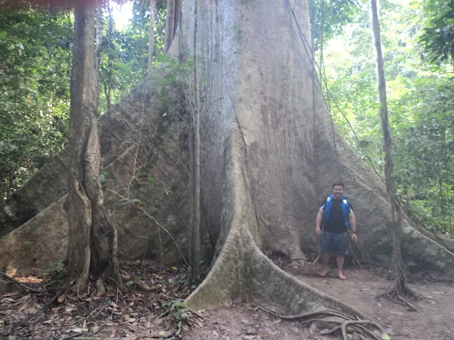
Tualang(Tapang) Tree of Kuala Tahan National Park/瓜拉大汉国家公园的大甘巴豆树
Mahseer(Kelah) Sanctuary/吉罗鱼养殖场
Starting Point of Trekking to Lata Berkoh/柏谷瀑布徒步起点
Kuala Tahan is the one of main gateways of the National Park/Taman Negara of Pahang where is named after the river confluence(Malay means Kuala) of Tahan River/Sungai Tahan & Tembeling River/Sungai Tembeling with several floating restaurants that famous for stargazing sites around the National Park/Taman Negara. The National Park/Taman Negara(formerly known as King George V National Park) is the largest & also the first national park of Malaysia since 1939 about 4343km2 located in the Central Forest Spine where is covered some parts of Pahang, Terengganu & Kelantan that managed by Department of Wildlife & National Parks(PERHILITAN) Peninsular Malaysia/Jabatan Perlindungan Hidupan Liar & Taman Negara Semenanjung Malaysia, it is also breeding more than 3000 species of plants such as Tahan Serdang Palm/Livistona tahanensis etc. & more than 500 species of animals such as Malayan Tapir, Mousedeer, Malayan Tiger(National Animal of Malaysia), Sun Bear(smallest bear species of the world) & Malaysian Mahseer/Kelah etc. Furthermore, the National Park is one of the oldest rainforests in the world about more than 130 millions years old with the highest cave formation in Malaysia about 730m high such as Telinga Cave/Gua Telinga. The National Park is also titled as ASEAN Heritage Park, International Union for Conservation of Nature(IUCN) National Park, Key Biodiversity Area(KBA), Important Bird Area(IBA) & Tentative Lists of UNESCO World Heritage Site. Canopy Walkway/Tree Top Walk is pedestrian walkway which is originally used for conducting research on the forest canopy(upper layer of forest) but now used for tourism purpose. Rapids is the natural phenomenon in the more steeper section of the river where the river becoming shallower & the rocks are exposed to the surface then air bubbles mixed with water formed the whitewater. The Batek/Bateq are the one of Malaysian Aborigines/Orang Asli tribes whose are lived in nomadic hunter-gatherer style that majority lived in National Park/Taman Negara between Pahang, Kelantan & Terengganu and Malaysian Aborigines/Orang Asli are the indigenous groups of Peninsular Malaysia whose are consists of three main community groups called Semang, Senoi & Proto-Malay. Malaysian Mahseer/Kelah is the native fish of South East Asia which will be back to the upstream of the river for laying eggs when it reach the mature period. Tropical Rainforest is the ecosystem located in the equatorial zone between the Tropic of Cancer/Northern Tropic & Tropic of Capricorn/Southern Tropic which does not have dry seasons, warm temperature & average annual rainfalls is high. The first national park in the world is the Yellowstone National Park of United States. Located near the National Park/Taman Negara is the Al-Sultan Abdullah Royal Tiger Reserve which is the first tiger reserve of Malaysia & South East Asia since 2023.
Attractions:
i.Park Centre & Mini Market
ii.Kelah Square
-the mini aquarium of 
Malaysian Mahseer/Kelah of National Park.
iii.Tahan Hide
-the hide where can watching the salt licks that provided nutrients for animals that arrived by night walk.
iv.Terisek Hill/Bukit Terisek
-the hill about 344m high where can looking the Mount Tahan/Gunung Tahan.
v.Canopy Walkway
-one of the longest canopy walkways/tree top walks of Malaysia about 530m long.
vi.Tahan Jetty/Rapids Shooting
-the boat ride along the river rapids of Tembeling River where can visiting the Batek/Bateq tribe community village.
vii.Lata Berkoh Boat Ride
-the Tahan River boat ride where can visiting the Mahseer/Kelah Sanctuary & Lata Berkoh Waterfalls.
viii.Mount Tahan/Gunung Tahan(formerly known as Batu Relai)
-the highest peak of Peninsular Malaysia about 2187m high.

The Things Must Do:
1.Participating the Night Jungle Walk to search some wildlife & insects.
2.Learning about the flora & fauna of National Park.
3.Visiting the Terisek Hill/Bukit Terisek.
4.Walking across the Canopy Walkway.
5.Take a look the Jeram Panjang Rapids during the rapids shooting.
6.Learning the fire making skill & blowpipe shooting skill of Batek/Bateq tribe.
7.Enjoying the Lata Berkoh Boat Ride like watching the Tualang/Tapang Tree.
8.Feeding the Malaysian Mahseer/Kelah at Mahseer/Kelah Sanctuary.

Arrival Date
29,30 & 31 July 2017
*Maybe mistake in information.
Malay Name
Taman Negara Kuala Tahan
Location
Jerantut-Kuala Tahan Road(Route 1508)/Jalan Jerantut-Kuala Tahan,Kuala Tahan
Google Map GPS Coordinate(approximately)
4.383537, 102.401473
Opening Hours
Following to your activities
Opening Hours(Canopy Walkway)
9am-3pm,Closed on Friday
Tel for Guided Tours Services
09-2672131/019-9811241/019-9831241
Attention
1.Do not enter this area during rainy seasons.
2.The National Park must be arrived by boat.
3.This area must visit accompanied by guided tour.
4.You must following the instructions of tour guide while in activities.
5.Beware of poisonous snakes.
6.Do not stand & taking photo on the canopy walkway.
7.You will getting wet during Rapid Shooting Trip.
8.Lata Berkoh Boat Trip is opening according to weather conditions.
9.Visitors must have physically fit & good health for visiting this area.
10.Keeping the National Park clean.
11.Do not soak in the water while you are applied the sunscreen lotion.
12.Do not bath with soap, body shampoo & shampoo in here.  
Entrance Fee
Below the RM5 per person(including the boat fee)
Below the RM10 per camera
*Some activities fees, please refer to the guided tour or park centre.
Fishing Permit Fee
Below the RM15 per rod
Entrance Fee(Canopy Walkway)
Below the RM10 per person
Lata Berkoh Boat Trip Fee
Above the RM100 per boat(Maximum Persons: Four Persons)
Mount Tahan Hiking Fee
Above the RM200 per one guide for 7 Days
Website
www.wildlife.gov.my/en/taman-negara-pahang-kuala-tahan
Website(Guided Tour Services)
www.tamannegara.my/v1

瓜拉大汉是以大汉河与淡贝岭河交界处(在马来文称为Kuala)来命名的拥有多间水上餐厅同时也以国家公园周围的观星活动区闻名的彭亨的国家公园的其中一个入口。设立于一九三九年的国家公园(前名为国王乔治五世国家公园)是坐落在中央森林脊椎内由马来西亚半岛野生动物与国家公园保护局(Jabatan Perlindungan Hidupan Liar & Taman Negara Semenanjung Malaysia/PERHILITAN)所管理的涵盖了彭亨、登嘉楼与吉兰丹部分地区的约四千三百四十三平方公里的马来西亚最大兼第一座国家公园,它也抚育了超过三千种植物品种如名为塔汉蒲葵(Tahan Serdang)的棕榈科植物等以及超过五百种动物品种如马来貘/亚洲貘/四不像/食梦兽、鼠鹿、马来亚虎(马来西亚国兽)、马来熊(全世界最小的熊类品种)与似野结鱼/马来西亚结鱼/吉罗鱼等。另外,国家公园也是拥有约七百三十米高如耳洞(Telinga Cave/Gua Telinga)的全马来西亚半岛最高的洞穴系统的约岁数超过一亿三千万年的全世界最古老的热带雨林之一。国家公园也是东盟遗产公园、国际自然保护联盟国家公园、生物多样性重点区域、重点鸟区与联合国教科文组织世界遗产暂定名单。树冠层吊桥/树冠层步道是原是用以在树冠层(森林最上层)上进行考察研究用途但现为旅游用途的行人步道。急流是河流较斜的部分形成河流变浅以及石头露出水面而空气泡混入水里形成白色水花。巴迪族(Batek/Bateq)是大多数居住在彭亨、吉兰丹与登嘉楼/丁加奴之间的国家公园内以游牧狩猎采集方式生活的马来西亚半岛原住民部落之一以及马来西亚半岛原住民是包含了塞芒人、仙奴伊人与原始马来人三个主要部落的原住民群体社群。似野结鱼/马来西亚结鱼/吉罗鱼是在到达成年期时会回到河流的上游来产卵的原生东南亚鱼类。热带雨林是位于北回归线(Tropic of Cancer/Northern Tropic)与南回归线(Tropic of Capricorn/Southern Tropic)之间的赤道地带内没有旱季、温度暖和与高雨水量的生态系统。全世界第一座国家公园是美国的黄石国家公园。位于国家公园旁就是设立于二零二三年的马来西亚及东南亚第一座老虎保护区苏丹阿都拉皇家老虎保留地。
景点:
i.公园中心与微型商店
ii.似野结鱼/马来西亚结鱼/吉罗鱼广场
-国家公园的似野结鱼/马来西亚结鱼/吉罗鱼的小型水族馆。
iii.大汉观景台
-以夜行徒步来到达的看见提供动物营养的盐沼的瞭望台。
iv.特勒锡山
-约三百四十四米高的可看见大汉山的山丘。
v.树冠层吊桥
-约五百三十米长的全马来西亚其中一条最长的树冠层吊桥之一。
vi.大汉码头/急流游船
-沿着淡贝岭河的急流上行走的可参观巴迪族(Batek/Bateq)部落村庄的游船服务。
vii.柏谷瀑布游船
-可参观似野结鱼/马来西亚结鱼/吉罗鱼养殖场与柏谷瀑布等的大汉河的游船服务。
viii.大汉山
-约两千一百八十七米高的马来西亚半岛最高峰。

一定要做的事:
1.参与夜行徒步活动去寻找野生动物与昆虫。
2.了解国家公园的动植物。
3.参观特勒锡山。
4.在树冠层吊桥上行走。
5.在急流游船中观赏班让急流(Jeram Panjang)。
6.了解巴迪族(Batek/Bateq)部落的生火技术与吹管箭射击技术。
7.享受柏谷瀑布游船例如观看大甘巴豆树。
8.在似野结鱼/马来西亚结鱼/吉罗鱼养殖场喂食似野结鱼/马来西亚结鱼/吉罗鱼。

到访日期
二零一七年七月二十九日、三十日与三十一日
*资讯可能有错误。
马来名称
Taman Negara Kuala Tahan
位置
瓜拉大汉而连突-瓜拉大汉路(一五零八号公路)/Jalan Jerantut-Kuala Tahan,Kuala Tahan
谷哥地图导览座标(估计性)
4.383537, 102.401473
开放时间
依据你的活动而定
树冠层吊桥开放时间
早上九点至下午三点,星期五休息
导览服务预约
09-2672131/019-9811241/019-9831241
注意
(一)禁止在雨季时到这里游玩。 
(二)国家公园必须乘船到达。
(三)这个地区必须跟随导览团队参观。
(四)你必须跟从向导的指示进行活动。
(五)小心毒蛇。
(六)禁止在树冠层吊桥上停着与拍照。
(七)你会在
急流游船中会被泼湿。
(八)柏谷瀑布船游是根据气候状况开放。
(九)参观这里的游客需体力充足与健康状况良好。
(十)请保持国家公园的清洁。 
(十一)禁止以擦上防晒露/防晒油来浸泡在水里。
(十二)禁止用肥皂、沐浴露与洗发水来在这里洗澡。
入门票
一个人马币低过五令吉(包括船费在内)
一架照相机低过十令吉
*一些活动费需向导览团队或公园中心询问。
钓鱼准证费
一支鱼竿低过十五令吉
树冠层吊桥入门票
一个人马币低过十令吉
柏谷瀑布游船船费
一艘船马币高过一百令吉(最高人数为四个人)
大汉山登山费
一位向导七天马币高过两百令吉
网址
www.wildlife.gov.my/en/taman-negara-pahang-kuala-tahan
导览服务网址
www.tamannegara.my/v1
 
Location Map/位置图:


Government Clinics/政府诊所:
1.Kuala Tahan Health Clinic(Klinik Kesihatan)/瓜拉大汉政府诊所
   Google Map GPS Coordinate(approximately)/谷哥地图导览座标(估计性): 4.382222, 102.401528


Food in Kuala Tahan/瓜拉大汉美食:
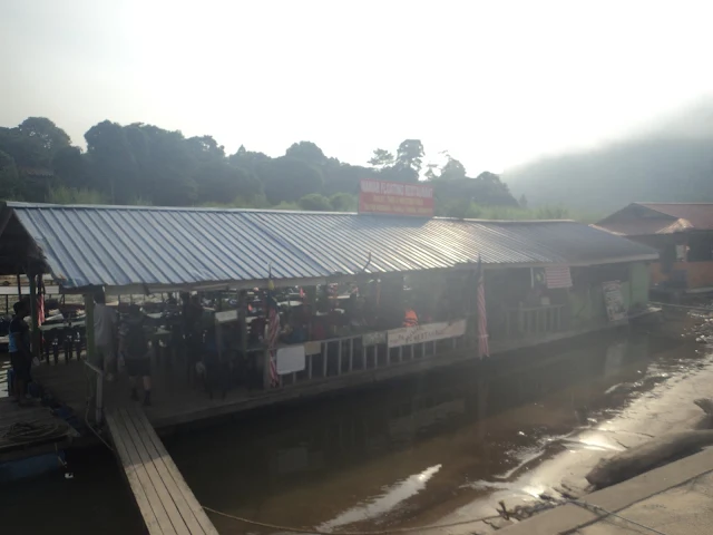
Mawar Floating Restaurant
Mawar 水上餐厅
Location/位置: Kuala Tahan Jetty/Jeti Kuala Tahan,Kuala Tahan
Location Map/位置图:

END
结束


You can also visited/你也可到访:
Kuantan & Pekan/关丹与北根
Website/网址:Click here/请按这里

Lanchang/联增 
Website/网址:Click here/请按这里

Gohtong Jaya & Genting Highlands/梧桐再也与云顶高原
Website/网址:Click here/请按这里

Raub/劳勿 
Website/网址:Click here/请按这里

Bentong & Janda Baik/文冬与贞德拜
Website/网址:Click here/请按这里

Bukit Tinggi/武吉丁宜
Website/网址:Click here/请按这里

Temerloh & Triang(Teriang)/淡马鲁与直凉
Website/网址:Click here/请按这里

Kuala Lipis & Benta/立卑与文打(文达)
Website/网址:Click here/请按这里

Kuala Rompin & Tioman Island(Pulau Tioman)/瓜拉云冰与刁曼岛
Website/网址:Click here/请按这里

Fraser's Hill(Bukit Fraser)/福隆港
Website/网址:Click here/请按这里

Jerantut & National Park(Taman Negara)/而连突与国家公园
Website/网址:Click here/请按这里

Maran & Gambang/马兰与甘
Website/网址:Click here/请按这里

Cameron Highlands/金马伦高原(金马仑高原)
Website/网址:Click here/请按这里
 
Sungai Lembing/林明
Website/网址:Click here/请按这里
 
Cherating(Cerating)/遮拉丁


Accommmodations near Jerantut & National Park(Taman Negara)/而连突与国家公园附近住宿:
*The hotel that listed below only for consideration.
*以下酒店只供参考。

Luxury Hotel/豪华酒店:
Mutiara Taman Negara Eco Park Resort=609-2662200
Location/位置: Kuala Tahan National Park/Taman Negara Kuala Tahan
Price/价钱: Above the RM200/马币两百令吉以上

Budget Hotel/廉价酒店:
Yellow Guest House=017-9463357/09-2664243
Location/位置: Sungai Deli Road/Jalan Sungai Deli,Kuala Tahan
Price/价钱: From RM90 to RM150/马币九十令吉至一百五十令吉之间


Distance/距离:
*The distances show at below are only approximate.
*以下只是大概距离。

K.L.I.A.-Kota Gelanggi Caves Heritage Park=250km
吉隆坡国际机场-哥打哥朗宜洞遗产公园=两百五十公里
Sultan Ahmad Shah Airport-Kuala Tahan National Park=211km
苏丹阿末沙机场-瓜拉大汉国家公园=两百一十一公里
Kota Gelanggi Caves Heritage Park-Kuala Tahan National Park=68.1km
哥打哥朗宜洞遗产公园-瓜拉大汉国家公园=六十八点一公里

Itinerary of Jerantut & National Park(Taman Negara) based on my suggestion/我本身建议的而连突与国家公园的旅程:
Days that I suggest to travel in here/我本身建议在这里游玩的时间=3 Days/三天
Must Visit Attractions/必游景点:
1.Kota Gelanggi Caves Heritage Park/哥打哥朗宜洞遗产公园
2.Kuala Tahan National Park/瓜拉大汉国家公园

First Day/第一天(departure from K.L.I.A. or Sultan Ahmad Shah Airport/从吉隆坡国际机场或苏丹阿末沙机场出发)
*According to guided tour.
*依据导览团队而定。

Second Day/第二天:
*According to guided tour.
*依据导览团队而定。

Third Day/第三天:
*According to guided tour.
*依据导览团队而定。

End of the Trip
旅程结束

Sunday, 4 June 2017

Area 10 of Pahang/彭亨第十区:Fraser's Hill(Bukit Fraser)/福隆港

Fraser's Hill(Bukit Fraser)/福隆港:
Arrival Date/到达日期: 4 June 2017/二零一七年六月四日
 
 
Attention/注意:
The road to Fraser's Hill is very narrow & very zigzag.
前往福隆港的公路非常狭窄与非常曲折。

Please avoiding travel in here during the rainy season, heavy rain can caused landslides.
请避免在雨季期间到此地旅行,强降雨可导致土崩。  

Fraser's Hill(Bukit Fraser)/福隆港:
Fraser's Hill Clock Tower/福隆港钟楼
Fraser's Hill is the mountain resort, wildlife reserve, Key Biodiversity Area(KBA) & Important Bird Area(IBA) located inside the Titiwangsa Mountains/Titiwangsa Range can be arrived from Raub of Pahang State & Kuala Kubu Bharu of Selangor State that named after the British tin miner who is founded the tin mining area in here, late Mr.Louis James Fraser has been titled as Little England of Malaysia. This mountain resort is the destination that suitable for natural lovers to do bird watching, picnic, golfing & jungle trekking, it is also famous for a lot of resort bungalows and trapdoor spiders especially Malayan Black Trapdoor Spider/Liphistius malayanus. The jungle trails of Fraser's Hill is consists of Mager Trail, Kindersley Trail, Abu Suradi Trail, Hemmant Trail, Bishop's Trail, Maxwell Trail, Rompin Trail & Pine Tree Trail whose must be visiting with hiring the guide, it is breeding over 200 bird species like Rusty-Naped Pitta, Malayan Whistling Thrush, Silver-Eared Mesia & Himalayan Cutia etc. The hill is comes crowded with bird watching lovers during Fraser's Hill International Bird Race. The temperature of Fraser's Hill is range from 17 degree Celcius to 25 degree Celcius. Located not far from Kuala Kubu Bharu are the Rasa(not confused with Lasah of Perak & Rasah of Negeri Sembilan) where its name means taste in Malay word due to warm friendly feelings that its majority Chinese community are Hakka community whose are ancestry from Huizhou(惠州) Municipality of Guangdong Province of China) with commuter train services & the former residence of founder of Rasa, late Mr.Tan Boon Chia(陈文晟) since 1918 called Tan Boon Chia Mansion(大观园), the Sungai Tengi with wildlife rescue centre & Malayan Tapir conservation centre located inside the Sungai Dusun Wildlife Reserve whose are opened by Department of Wildlife & National Parks(PERHILITAN) Peninsular Malaysia/Jabatan Perlindungan Hidupan Liar & Taman Negara Semenanjung Malaysia and Sungai Panjang where is famous for firefly conservation centre that suggested to visit by taking the river cruise services along the Bernam River/Sungai Bernam for watching the fireflies by booking from telephone numbers on their official Facebook called Kelip-Kelip Sungai Panjang.

The Things Must Do:
1.Visiting the well-historic Kuan Yin Kok Temple in Ampang Pecah.
2.Admiring the architecture of Kuala Kubu Bharu Town.
3.Tasting the local street foods of Kuala Kubu Bharu.
4.Take photo of Fraser's Hill Clock Tower.
5.Playing the trikke scooter or mini golf at Public Park.
6.Take the pedal boat/paddle boat ride on Allan's Water.
7.Take a look the Jeriau Waterfalls.
8.Riding the horse a round and playing the archery & blowpipe shooting at The Paddock.

福隆港(前名为白须港)是坐落在蒂迪旺沙山脉内的被誉为马来西亚小英格兰的其英文名字以开辟这里的锡矿采矿区的英国锡矿家已故路易·詹姆士·福莱士(Louis James Fraser)先生来命名而中文名字则相信是源自于名叫福隆的锡矿矿场工头的可从彭亨州劳勿与雪兰莪州新古毛到达的避暑胜地、野生动物保护区、生物多样性重点区域与重点鸟区。这座避暑胜地是适合自然爱好者来旅游的目的地因这儿可以进行观鸟活动、野餐活动、打高尔夫球与森林徒步活动,它也以许多独立式洋房度假屋与活板门蛛尤其是马来西亚节板蛛闻名。福隆港的需聘请向导来参观的森林途径包含马戈路径、金德斯莱路径、阿布苏拉迪路径、赫曼路径、主教路径、麦西维路径、云冰路径与松树路径,它抚育着像栗头八色鸫、马来啸鸫、银耳相思鸟与斑胁姬鹛等超过两百种鸟类品种。这里在福隆港国际观鸟赛期间充满许多观鸟爱好者。福隆港的温度位于十七摄氏度至二十五摄氏度之间。位于新古毛不远处就是其名字是因温情味而以意思为味道的马来文Rasa 来命名的其华人社群以祖籍中国广东省惠州市的客家社群为多数的含有通勤列车/通勤火车服务和建于一九一八年的叻思开辟者已故陈文晟先生的故居大观园的叻思(前名为叻沙/拉沙/叻思坡/叻思埠/叻思布/叻思婆)(别与霹雳的叻沙(Lasah)与森美兰的亚沙(Rasah)混淆)、含有两者都是由马来西亚半岛野生动物与国家公园保护局(Jabatan Perlindungan Hidupan Liar & Taman Negara Semenanjung Malaysia/PERHILITAN)所开的野生动物拯救中心与坐落在双溪杜顺野生动物保护区内的马来貘/亚洲貘/四不像/食梦兽保育中心的双溪登宜以及以建议需通过其官方脸书/面子书Kelip-Kelip Sungai Panjang 的电话号码来预订搭乘沿着安南河来观赏萤火虫的游船服务来参观的萤火虫公园闻名的双溪班让。

一定要做的事:
1.参观旧古毛的充满历史性的观音阁古庙/观音古寺。
2.欣赏新古毛镇的建筑物。
3.品尝新古毛的当地街头美食。
4.拍下福隆港钟楼的照片。
5.在民众公园内玩滑板车或微型高尔夫球。
6.在阿伦湖内划脚踏船。
7.观赏遮里奥瀑布。
8.在马场内骑马一圈、射箭与射吹管箭。

Attractions in Fraser's Hill/福隆港景点:
I.Kuan Yin Kok Temple/观音阁古庙(观音古寺)
 
 
Government Clinics/政府诊所:
1.Fraser's Hill Health Clinic(Klinik Kesihatan)/福隆港政府诊所
   Google Map GPS Coordinate(approximately)/谷哥地图导览座标(估计性): 3.711667, 101.736333
2.Rasa Health Clinic(Klinik Kesihatan)/叻思政府诊所
   Google Map GPS Coordinate(approximately)/谷哥地图导览座标(估计性): 3.498139, 101.636667


Attractions in Fraser's Hill/福隆港景点:
I.Kuan Yin Kok Temple/观音阁古庙(观音古寺):
*This attraction located in Selangor State of Malaysia.
*此景点坐落在马来西亚雪兰莪州。
Kuan Yin Kok Temple/观音阁古庙(观音古寺)
Monuments of Three Abbots of Temple/庙宇三位方丈的纪念碑
Kuan Yin Kok Temple is the former Buddhist temple of Ampang Pecah(formerly known as Kuala Kubu) where is the one of only two historical buildings that survived after the Kuala Kubu Tragedy on 1926(this tragedy is also famous for legend of white crocodile) due to its geographical position, it is dedicated to Chinese, Buddhist & Taoist Goddess of Mercy/Lord Avalokitesvara(观世音菩萨/观音大士/慈航真人/慈航大士) where is founded by China born Buddhist monk, Venerable Shan Qing(English translate)(释善庆) on 1904 has been titled as Tortoise Temple because the locals are liberating the tortoise in here, it is also known as the second home of Kek Lok Si Temple of Penang. Furthermore, this temple is contains various historical deities statues & religious tools. The Goddess of Mercy/Avalokiteśvara's Birthdays is celebrated during the Nineteenth Day of Second Month(Birthday), Nineteenth Day of Sixth Month(Enlightment Day) & Nineteenth Day of Ninth Month(Nirvana Day) of Chinese Lunar Calendar. Buddhism is the religion that founded by Gautama Buddha/Shakyamuni Buddha with its main symbols are five coloured Buddhist flag & Dharma Wheel, its most iconic structure is the Mahabodhi Temple Complex of Bodh Gaya from India. The Chinese temple architectural style is the temple that constructed based on Chinese philosophy called Feng Shui(风水) with the structure features like dougong/wooden bracket system(斗栱), curved roof & eaves etc. Located near the temple is the Millennium Park where is the famous paragliding site that the paragliding activities are need to participate by booking from local tour operator first.

Arrival Date
4 June 2017
*Maybe mistake in information.
Location
Ampang Pechah Road/Jalan Ampang Pechah,Ampang Pecah(pay attention for the signboards)
Google Map GPS Coordinate(approximately)
3.537341, 101.662318
Opening Hours
Unknown
Attention
Do not acting any indecent behaviour inside the temple area.
Entrance Fee
Free 

观音阁古庙/观音古寺是因当地人们在这里放生乌龟而被称为乌龟庙的由中国出生佛教僧侣释善庆法师在一九零四年所创立的供奉着华人民间信仰、佛教兼道教慈悲神明观世音菩萨/观音大士/慈航真人/慈航大士的旧古毛的前佛寺,它是旧古毛唯一两座因它的地理位置而在以白鳄鱼传说闻名的一九二六年古毛大水灾事件后依然仅存的两座历史建筑物之一,它也是槟城/槟榔屿鹤山极乐寺的别院。另外,这间庙宇也拥有许多古老神像与古老宗教法器。观音诞是在华人农历二月十九日(生日)、六月十九日(成道日)与九月十九日(涅槃日)期间庆祝。佛教是由释迦牟尼/佛陀创立以五色佛教旗与法轮为主要标志的宗教,其最标志性的建筑物就是印度菩提伽耶的摩诃菩提寺。中式/汉式庙宇建筑风格是根据华人/汉人风水哲理来建造像斗栱/木制支架系统、曲线型屋顶与屋檐等建筑特色的庙宇。位于庙宇附近就是其滑翔伞活动需预订当地旅行社先来参加的著名滑翔伞区千禧公园。

到访日期
二零一七年六月四日
*资讯可能有错误。
位置
旧古毛旧古毛路/Jalan Ampang Pechah,Ampang Pecah(注意路牌)
谷哥地图导览座标(估计性)
3.537341, 101.662318
开放时间
不明确
注意
禁止在庙宇范围作出不雅行为。
入门票
免费

Location Map/位置图:


II.Kuala Kubu Bharu Garden Town Heritage/新古毛花园镇遗产:
*This attraction located in Selangor State of Malaysia.
*此景点坐落在马来西亚雪兰莪州。
King George VI Clock Tower/国王乔治六世纪念碑
Kuala Kubu Bharu Town/新古毛镇
Mural of Kuala Kubu Bharu Town/新古毛镇壁画
Kuala Kubu Bharu(also known as K.K.B.) is the first planned garden city in Malaysia where is built after Kuala Kubu Tragedy on 1926(this tragedy is also famous for legend of white crocodile) that contains the public hospital, it is planned by New Zealand born urban planner, late Mr.Charles Reade with influence of garden city movement has been surrounded by recreational parks where is contains various historical shophouses & amentities such as police station, fire station, movie theater/cinema & post office etc. that can going around the town by cycling, it is also comes crowded during the Wings of KKB Selangor Birds Fair & Rice Cake/New Year Cake Making Activities before Spring Festival/Chinese New Year are held on every year. Furthermore, Kuala Kubu Bharu is also the district capital of Hulu Selangor & local government seat of Hulu Selangor Municipal Council/Majlis Perbandaran Hulu Selangor with its name is derived from the Kubu means fortress in Malay word due to the fortress that built near the Selangor River/Sungai Selangor in the Kuala Kubu/Ampang Pecah & Bharu means new in Malay word where is also famous for whitewater rafting along the Selangor River/Sungai Selangor that need to participate by booking from local tour operators first. 
Attractions:
i.King George VI Clock Tower
-the clock tower for commemorating the coronation of British King George VI of House of Windsor.
ii.Ilmio Cafe
-the cafe & homestay that showing the vintage items of Malaysian Chinese New Village/Kampung Baru.
iii.K.K.B.Time Corridor/Denai Masa K.K.B.
-the murals lane that showing the old environment scenes of Kuala Kubu Bharu.

Arrival Date
3 June 2017
*Maybe mistake in information.
Malay Name
Warisan Bandar Taman Kuala Kubu Bharu
Location
Dato Muda Jaafar Road/Jalan Dato Muda Jaafar,Kuala Kubu Bharu(Kuala Kubu Bharu Town)
Bukit Kerajaan Road/Jalan Bukit Kerajaan,Kuala Kubu Bharu(King George VI Clock Tower)
Google Map GPS Coordinate(approximately)
3.564081, 101.659011(Kuala Kubu Bharu Town)
3.562176, 101.659073(King George VI Coronation Clock Tower)
Attention
Keeping the area clean.
Entrance Fee
Free

新古毛(前名为雪牙岳)是以白鳄鱼传说闻名的一九二六年古毛大水灾事件后建造的含有公共医院的马来西亚第一座规划花园城市,它由新西兰/纽西兰出生的城市规划师已故查尔斯·里德(Charles Reade)先生受花园城市运动所影响而规划出来的可通过骑自行车/脚踏车/单车来游览其周围的被休闲公园所环绕着的拥有多间古老店屋与公共设施如警察局、消防局、电影院/戏院与邮政局等的市镇,它在每年举办的新古毛雪兰莪观鸟赛(Wings of KKB Selangor Birds Fair)以及春节/农历新年前夕的蒸年糕活动期间吸引人潮。另外,新古毛是其名字源自于马来文Kubu 意译为堡垒因在旧古毛雪兰莪河附近曾建立一座堡垒而Bharu 在马来文意译为新而中文名字古毛则是客家方言的发音而来的也以需从当地旅行社预订先才能参与的沿着雪兰莪河中激流泛舟闻名的乌鲁雪兰莪的县府与乌鲁雪兰莪市议会(Majlis Perbandaran Hulu Selangor)的地方政府所在地。
景点:
i.国王乔治六世纪念碑
-用以纪念英国温莎王朝国王乔治六世(King George VI)加冕的钟楼。
ii.古毛人茶餐室
-展示着马来西亚华人新村的旧物的咖啡厅兼民宿。
iii.新古毛时光走廊
-展示着新古毛旧时环境场景的壁画巷。


到访日期
二零一七年六月三日
*资讯可能有错误。
马来名称
Warisan Bandar Taman Kuala Kubu Bharu
位置
新古毛拿督姆达查化路/Jalan Dato Muda Jaafar,Kuala Kubu Bharu(新古毛镇)
新古毛政府山路/Jalan Bukit Kerajaan,Kuala Kubu Bharu(国王乔治六世纪念碑)
谷哥地图导览座标(估计性)
3.564081, 101.659011(新古毛镇)
3.562176, 101.659073(国王乔治六世纪念碑)
注意
请保持地区的清洁。
入门票
免费

Location Map/位置图:


III.Selangor River Dam/雪兰莪河水坝:
*This attraction located in Selangor State of Malaysia.
*此景点坐落在马来西亚雪兰莪州。
Selangor River Dam/雪兰莪河水坝
It is the largest reservoir of Selangor & also the famous stargazing site of Malaysia which is built in the one of the headstreams of the Selangor River/Sungai Selangor for water supply purpose that famous its first stop can viewing the main hole of the dam. The earliest dam that built in the world is Jawa Dam of Jordan. Located near the dam is the Chiling River Fish Sanctuary/Santuari Ikan Sungai Chiling where is one of the headstreams of Selangor River/Sungai Selangor with waterfalls and cascades located inside the Hulu Selangor Forest Reserve of Royal Selangor Heritage Forest of Titiwangsa Mountains/Titiwangsa Range need to be arrive by walking the jungle trails that managed by Department of Fisheries of Malaysia/Jabatan Perikanan Malaysia that breeding the endangered fish species called Malaysian Mahseer/Kelah. Malaysian Mahseer/Kelah is the native fish of South East Asia which will be back to the upstream of the river for laying eggs when it reach the mature period. Waterfalls is natural phenomenon which the water flows will be vertical drop into the plunge pool that formed with the erosion of the soft rock below the hard rock rapidly than hard rock & cascades is the mini waterfalls which is caused by rock steps.

Arrival Date
3 June 2017
*Maybe mistake in information.
Malay Name
Empangan Sungai Selangor
Location
Route 55,Kuala Kubu Bharu
Google Map GPS Coordinate(approximately)
3.571649, 101.705341(First Stop)
3.562176, 101.659073(Second Stop)
3.594308, 101.735314(Chiling River Fish Sanctuary)
Opening Hours(First Stop)
Unknown
Opening Hours(Chiling River Fish Sanctuary)
Friday-Sunday: 8am-6pm
Closed on Monday-Thursday
Attention
Keeping the area clean. 
Entrance Fee
Free
Entrance Fee(Chiling River Fish Sanctuary)
Below the RM5 per person

这是在雪兰莪河其中一个源头内建造用以水供用途的以其第一站可看见水坝的主要洞口闻名的雪兰莪最大的水坝兼马来西亚著名的观星活动区。全世界最早建造的水坝就是约旦名为Jawa 的水坝。位于水坝附近就是坐落在蒂迪旺沙山脉的雪兰莪皇家遗产森林的乌鲁雪兰莪森林保护区内的需步行森林路径来到达的由马来西亚渔业局(Jabatan Perikanan Malaysia)所管理的内部含有瀑布与小瀑布的抚育着濒危鱼类物种似野结鱼/马来西亚结鱼/吉罗鱼的雪兰莪河的源头之一吉灵河似野结鱼/马来西亚结鱼/吉罗鱼养殖场。似野结鱼/马来西亚结鱼/吉罗鱼是在到达成年期时会回到河流的上游来产卵的原生东南亚鱼类。瀑布是由硬石层底下的软石层侵蚀快过硬石层而形成直垂下水潭的水流的自然现象而小瀑布则由石级导致而成。

到访日期
二零一七年六月三日
*资讯可能有错误。
马来名称
Empangan Sungai Selangor
位置
新古毛五十五号公路
谷哥地图导览座标(估计性)
3.571649, 101.705341(第一站)
3.562176, 101.659073(第二站)
3.594308, 101.735314(吉灵河似野结鱼/马来西亚结鱼/吉罗鱼养殖场)
第一站开放时间
不明确
吉灵河似野结鱼/马来西亚结鱼/吉罗鱼养殖场开放时间
星期五至星期日: 早上八点至傍晚六点
星期一至星期四休息
注意
请保持地区的清洁。
入门票
免费
吉灵河似野结鱼/马来西亚结鱼/吉罗鱼养殖场入门票
一个人马币低过五令吉
 
Location Map/位置图:


IV.Fraser's Hill Clock Tower/福隆港钟楼:
Fraser's Hill Clock Tower/福隆港钟楼
Fraser's Hill Sports Complex/福隆港体育中心
Fraser's Hill Golf Club/福隆港高尔夫球俱乐部
Tourist Information Centre/旅游质询中心
Bird Interpretive Centre/鸟类解说中心
It is the mini clock tower of Fraser's Hill which is served as the landmark of Fraser's Hill that surrounded by golf club & also English Tudor architectural style buildings such as restaurant, police station, government clinic, & post office etc. The Fraser's Hill Tourist Information Centre with bicycle rental services and Bird Interpretive Centre for displaying the resources of Fraser's Hill like history, tourism & birds etc. on the first floor of Sports Complex are also located in here. The Tudor architectural style is the English Tudor period architectural style that featured the timber framing, pitched roof & long gallery.

Arrival Date
3 June 2017
*Maybe mistake in information.
Location
Gap-Fraser Hill Road/Jalan Gap-Bukit Fraser
Google Map GPS Coordinate(approximately)
3.711869, 101.736417
Opening Hours(Bird Interpretive Centre)
Weekends: 10am-7pm
Attention
Keeping the area clean.
Entrance Fee
Free

这是作为福隆港的标志的被高尔夫球俱乐部还有如餐馆、警察局、政府诊所与邮政局等英国式都铎建筑风格的建筑物环绕着的福隆港的小型钟楼。含有自行车/脚踏车/单车租借服务福隆港的旅游咨询中心以及坐落在体育中心二楼上的用以展览着福隆港的资讯像历史、旅游和鸟类等的鸟类解说中心也坐落此地。都铎建筑风格是以木骨架、倾斜屋顶与长廊为特色的英格兰都铎时期的建筑风格。

到访日期
二零一七年六月三日
*资讯可能有错误。
位置
峡谷-福隆港路/Jalan Gap-Bukit Fraser
谷哥地图导览座标(估计性)
3.711869, 101.736417
鸟类解说中心开放时间
周末: 早上十点至傍晚七点 
注意
请保持地区的清洁。
入门票
免费

Location Map/位置图:


V.Public Park/民众公园:
Public Park/民众公园
Public Park/民众公园
Public Park/民众公园
Public Park/民众公园
It is the recreational park of Fraser's Hill that consists of children playground, food court, rural clinic/klinik desa, trikke scooter lane & mini golf course. The modern golf games is originated from the Scotland of Great Britain & trikke is three wheeled vehicle that designed by Mr.Gildo Beleski who is founder of American entrepreneur called Trikke Tech Inc.

Arrival Date
4 June 2017
*Maybe mistake in information.
Malay Name
Taman Awam/Taman Kanak-Kanak
Location
Pine Tree Road/Jalan Pokok Pine
Google Map GPS Coordinate(approximately)
3.714877, 101.733992
Opening Hours(Trikke & Mini Golf)
Sunday-Thursday: 9am-12.30pm,2pm-4.30pm
Friday: 9am-12pm,2.45pm-4.30pm
Saturday & Public Holidays: 9am-12.30pm,2pm-7pm
Attention
Keeping the area clean. 
Entrance Fee
Free
Entrance Fee(Trikke & Mini Golf)
Below the RM15 per person per 15 Minutes(Trikke)
Below the RM15 per person per 30 Minutes(Mini Golf)

这是拥有儿童游乐场、美食中心、乡村诊所(Klinik Desa)、滑板车步道与微型高尔夫球场的福隆港的休闲公园。现代高尔夫球游戏是源自于英国苏格兰与滑板车是由美国企业帅克科技有限公司(Trikke Tech Inc.)创办人吉尔多·贝尔斯基(Gildo Beleski)先生所发明。

到访日期
二零一七年六月四日
*资讯可能有错误。
马来名称
Taman Awam/Taman Kanak-Kanak
位置
松树路//Jalan Pokok Pine
谷哥地图导览座标(估计性)
3.714877, 101.733992
滑板车与微型高尔夫球开放时间
星期日至星期四: 早上九点至中午十二点半,下午两点至下午四点半
星期五: 早上九点至中午十二点,下午两点四十五分至下午四点半
星期六与公共假期: 早上九点至中午十二点半,下午两点至晚上七点
注意
请保持地区的清洁。
入门票
免费
滑板车与微型高尔夫球入门票
一个人十五分钟马币低过十五令吉(滑板车)
一个人三十分钟马币低过十五令吉(微型高尔夫球)
 
Location Map/位置图:


VI.Fraser's Edible Garden/福隆港蔬果园:
Fraser's Edible Garden/福隆港蔬果园
It is the organic strawberry farm & vegetables farm located near Allan's Water of Fraser's Hill. The garden strawberry is the hybrid fruit species of plants of Fragaria/Strawberries Genus of Rosaceae Family which the first garden strawberries were planted in Brittany of France & organic farming is the agricultural system that planting the agricultural crops by using the organic fertilizer, crop rotation & biological pest control.

Arrival Date
4 June 2017
*Maybe mistake in information.
Location
High Pines Road/Jalan High Pines
Google Map GPS Coordinate(approximately)
3.713614, 101.732678
Opening Hours
Unknown
Attention
1.Keeping the area clean.
2.Do not self plucking the fruits & vegetables without permission.   
Entrance Fee
Free

这是坐落在福隆港的阿伦湖旁的有机草莓园兼菜园。草莓是其第一群果实是在法国布列塔尼半岛内种植的蔷薇科草莓属植物的杂交种水果以及有机耕种是以有机肥料、轮耕栽种法与生物防治来种植农作物的农业系统。

到访日期
二零一七年六月四日
*资讯可能有错误。
位置
高松树路/Jalan High Pines
谷哥地图导览座标(估计性)
3.713614, 101.732678
开放时间
不明确
注意
(一)请保持地区的清洁。
(二)禁止未获批准下自摘水果与蔬菜。
入门票
免费
 
Location Map/位置图:


VII.Allan's Water/阿伦湖:
Allan's Water/阿伦湖
Allan's Water/阿伦湖
Allan's Water/阿伦湖
Allan's Water/阿伦湖
It is the former water supply purpose dam where is named after the Mr.J.H.Allan who wants to develop the Fraser's Hill during British colonial era has been transformed into the pedal boat/paddle boat recreational park. The late Mr.Leonardo da Vinci from Italy is believed to be the first person who designed the pedal boat/paddle boat. The earliest dam that built in the world is Jawa Dam of Jordan. 

Arrival Date
4 June 2017
*Maybe mistake in information.
Location
High Pines Road/Jalan High Pines
Google Map GPS Coordinate(approximately)
3.713334, 101.732621
Opening Hours
Sunday-Thursday: 9am-12.30pm,2pm-4.30pm
Friday: 9am-12pm,2.45pm-4.30pm
Saturday & Public Holidays: 9am-12.30pm,2pm-7pm
Attention
1.The pedal boat/paddle boat maximum for two persons seated only.
2.Keeping the area clean.
Entrance Fee 
Free  
Pedal Boat/Paddle Boat Fee
Below the RM15 per person per 15 Minutes

这是现已转型为脚踏船休闲公园的以英国殖民时期想要发展福隆港的J.H.阿伦(J.H.Allan)先生来命名的前水供用途的水库。来自意大利的已故列奥纳多·达·芬奇(Leonardo da Vinci)先生相信是第一位设计脚踏船的人。全世界最早建造的水坝就是约旦名为Jawa 的水坝。

到访日期
二零一七年六月四日
*资讯可能有错误。
位置
高松树路/Jalan High Pines
谷哥地图导览座标(估计性)
3.713334, 101.732621
开放时间
星期日至星期四: 早上九点至中午十二点半,下午两点至下午四点半
星期五: 早上九点至中午十二点,下午两点四十五分至下午四点半
星期六与公共假期: 早上九点至中午十二点半,下午两点至晚上七点
注意
(一)脚踏船最高人数为两人乘坐。
(二)请保持地区的清洁。
入门票
免费 
脚踏船船费
一个人十五分钟马币低过十五令吉
 
Location Map/位置图:


VIII.Jeriau Waterfalls/遮里奥瀑布:
Jeriau Waterfalls/遮里奥瀑布
Jeriau Waterfalls is the multi tiered waterfalls & cascades recreational area of Fraser's Hill located inside the Batu Talam Dipterocarp Forest Reserve of Titiwangsa Mountains/Titiwangsa Range which is served as one of the headstreams of Pahang River/Sungai Pahang. Waterfalls is natural phenomenon which the water flows will be vertical drop into the plunge pool that formed with the erosion of the soft rock below the hard rock rapidly than hard rock & cascades is the mini waterfalls which is caused by rock steps. Dipterocarpaceae family are the trees mainly growth in the tropical rainforest & some are the endangered species.

Arrival Date
4 June 2017
*Maybe mistake in information.
Malay Name
Air Terjun Jeriau
Location
Waterfalls Road(Route 422)/Jalan Air Terjun
Google Map GPS Coordinate(approximately)
3.724794, 101.714583
Opening Hours
Unknown
Attention
1.Do not enter this area during rainy seasons.
2.Keeping the forest clean.
3.Do not soak in the water while you are applied the sunscreen lotion.
4.Do not bath with soap, body shampoo & shampoo in here.
Entrance Fee
Free

遮里奥瀑布是坐落在蒂迪旺沙山脉的峇都达南龙脑香森林保护区内作为彭亨河其中一个的源头的福隆港的多层瀑布与小瀑布休闲区。瀑布是由硬石层底下的软石层侵蚀快过硬石层而形成直垂下水潭的水流的自然现象而小瀑布则由石级导致而成。龙脑香科是主要生长在热带雨林中及一些还是濒危物种的树木。

到访日期
二零一七年六月三日
*资讯可能有错误。
马来名称
Air Terjun Jeriau
位置
瀑布路(四二二号公路)/Jalan Air Terjun
谷哥地图导览座标(估计性)
3.724794, 101.714583
开放时间
不明确
注意
(一)禁止在雨季时到这里游玩。
(二)请保持森林的清洁。
(三)禁止以擦上防晒露/防晒油来浸泡在水里。
(四)禁止用肥皂、沐浴露与洗发水来在这里洗澡。
入门票
免费
 
Location Map/位置图:


IX.The Paddock/马场:
The Paddock/马场
Horse Pavilion/骑马场
Paddock Pavilion/骑马场
Archery Pavilion/射箭场
The Paddock is the horse riding centre where is also provided the archery & blowpipe shooting activities. Horses are the animal of Equidae family of Perissodactyla order of Mammals that using by human for sports & battle purpose from past to current time & the horses in here are used for leisure purpose only. 
The archery is the human skill which is using the bow to shoot the arrow that appeared in the hunting during the Pre-Historic era & now it is the entertainment activity for games purpose.

Arrival Date
4 June 2017
*Maybe mistake in information.
Location
Valley Road(Route 56)/Jalan Valley
Google Map GPS Coordinate(approximately)
3.715108, 101.741123
Opening Hours(Paddock Pavilion)
Sunday-Thursday: 9am-12pm,2pm-4.30pm
Friday: 9am-12pm,2.45pm-4.30pm
Saturday & Public Holidays: 9am-12pm,2pm-7pm
Opening Hours(Archery Pavilion)
Sunday-Thursday: 9am-12.30pm,2pm-4.30pm
Friday: 9am-12pm,2.45pm-4.30pm
Saturday & Public Holidays: 9am-12.30pm,2pm-7pm
Attention
Keeping the area clean.
Entrance Fee
Below the RM15 per person(Horse Riding)
Below the RM15 per person per 10 Arrows(Archery)
Below the RM15 per person per 10 Arrows(Blowpipe Shooting)

马场是也提供射箭与吹管箭活动的骑马中心。马是人类从以前到现代都用以作为体育与战斗用途的哺乳类奇蹄目马科动物而在这里的马都是用以休闲用途的马儿。射箭是在史前时代就已经出现的以弓来射出箭来打猎的人类技术但现今它已用来作为游戏用途的娱乐活动。

到访日期
二零一七年六月四日
*资讯可能有错误。
位置
山谷路(五十六号公路)/Jalan Valley
谷哥地图导览座标(估计性)
3.715108, 101.741123
骑马场开放时间
星期日至星期四: 早上九点至中午十二点,下午两点至下午四点半
星期五: 早上九点至中午十二点,下午两点四十五分至下午四点半
星期六与公共假期: 早上九点至中午十二点,下午两点至晚上七点
射箭场开放时间
星期日至星期四: 早上九点至中午十二点半,下午两点至下午四点半
星期五: 早上九点至中午十二点,下午两点四十五分至下午四点半
星期六与公共假期: 早上九点至中午十二点半,下午两点至晚上七点
注意
请保持地区的清洁。
入门票
一个人马币低过十五令吉(骑马)
一个人十支箭马币低过十五令吉(射箭)
一个人十支箭马币低过十五令吉(吹管箭)
 
Location Map/位置图:


Food around Fraser's Hil/福隆港周围美食:
In Fraser's Hill/Bukit Fraser, visitors can eating the Scones which is the British bread/cake that served with jam & butter in the Ye Olde Smokehouse. In the Kuala Kubu Bharu, visitors can also buying the homemade Kaya Puff, Cup Cake & Butter Sponge Cake in the Teng Wun Bakery & Confectionery along the Dato Muda Jaafar Road(Maxwell Street)/Jalan Dato Muda Jaafar, this confectionery & also cake shop is also famous for the Durian Cake which is only made during the durian harvest seasons that need to buy by reservation first. Kaya is the jam which is made from coconut milk & egg that famous for serving with bread in Malaysia & Singapore.

在福隆港,游客可在吃到以配搭果酱与牛油来吃的英国面包或蛋糕司康饼/司康/英国茶饼/英国松饼/英式松饼。在新古毛,游客也可在墨水街购买到昇云西果店的手工制作加央角/加椰角、小蛋糕与牛油松糕,这间甜食店兼蛋糕店也以需预订先才能购买的在榴莲丰收季节期间才制造的榴莲蛋糕。加央/加椰是由椰奶与蛋制作出来的在马来西亚和新加坡的用以配搭面包来吃的果酱。

Ye Olde Smokehouse Fraser's Hill Afternoon Tea & Scone
福隆港Ye Olde 烟屋英国下午茶与司康饼/司康/英国茶饼/英国松饼/英式松饼
Location/位置: Jeriau Road/Jalan Jeriau,Fraser's Hill/Bukit Fraser
Location Map/位置图:

Yoot Loy Toasted Bread
悦来烤面包
Location/位置: Dato Muda Jaafar Road(Maxwell Street)/Jalan Dato Muda Jaafar,Kuala Kubu Bharu
Location Map/位置图:
 
Teng Wun Kaya Puff/Malaysian Eggy Flavour Coconut Milk Jam Flavoured Puff,Cup Cake,Butter Sponge Cake & Durian Cake
昇云加央角/加椰角/马来西亚蛋味椰奶果酱口味酥角、小蛋糕、牛油松糕与榴莲蛋糕
Location/位置: Dato Muda Jaafar Road(Maxwell Street)/Jalan Dato Muda Jaafar,Kuala Kubu Bharu
Tel for Reservations/预订拨电: 603-60641586
Location Map/位置图:
 
永乐 Hainanese Breads(Closed)
永乐海南面包(已关闭)
Location/位置: Dato Muda Jaafar Road(Maxwell Street)/Jalan Dato Muda Jaafar,Kuala Kubu Bharu

Sun Sun Nam Cheong Hainanese Fried Chicken Chop & Mee Hailam/Handmade Malaysian Hainanese Style Fried Noodles
新南昌海南炸鸡扒与海南面/马来西亚海南式炒手工面
Location/位置: Mat Kilau Road(Stoner Street)/Jalan Mat Kilau,Kuala Kubu Bharu 
Location Map/位置图:
 
Wong Ng Kee Braised Pork with Taro & Jiangnan Style Noodles/Deep Fried Uncooked Noodles with Egg Gravy
王伍记芋头扣肉与江南面/江南生面/蛋汁勾芡油炸生面
Location/位置: Mat Kilau Road(Stoner Street)/Jalan Mat Kilau,Kuala Kubu Bharu 

Kedai Makanan Lee Curry Mee/Curry Noodles Soup,Yam Cake,Economy Fried Noodles,Glutinous Rice & Red Bean Sweet Soup
群乐咖哩面/咖喱汤面、芋头糕、经济炒面、糯米饭与红豆汤/红豆水
Location/位置: Dato Tabal Road/Jalan Dato Tabal,Kuala Kubu Bharu
 
Keng Lim Hainan Tea(Malaysian Special Made Coffee+Tea) & Toasted Bread
19 琼林海南茶(马来西亚特制咖啡加茶)与烤面包
Location/位置: Kuala Kali Road/Jalan Kuala Kali,Rasa 
 
芳记 Wonton Noodles/Dumpling Noodles(Located inside the Happy Like Coffee House)
芳记馄饨面/云吞面(位于新快乐茶餐室内)
Location/位置: Kuala Kali Road/Jalan Kuala Kali,Rasa

Pork Offal Congee/Pork Offal Rice Porridge(Located inside the Residential House)(Afternoon to Night)
猪杂粥(位于住家内)(下午至晚上)
Location/位置: No.9,Kuala Kali Road/Jalan Kuala Kali,Rasa
Google Map GPS Coordinate(approximately)/谷哥地图导览座标(估计性): 3.495182, 101.630886

END
结束


You can also visited/你也可到访:
Kuantan & Pekan/关丹与北根
Website/网址:Click here/请按这里

Lanchang/联增 
Website/网址:Click here/请按这里

Gohtong Jaya & Genting Highlands/梧桐再也与云顶高原
Website/网址:Click here/请按这里

Raub/劳勿 
Website/网址:Click here/请按这里

Bentong & Janda Baik/文冬与贞德拜
Website/网址:Click here/请按这里

Bukit Tinggi/武吉丁宜
Website/网址:Click here/请按这里

Temerloh & Triang(Teriang)/淡马鲁与直凉
Website/网址:Click here/请按这里

Kuala Lipis & Benta/立卑与文打(文达)
Website/网址:Click here/请按这里

Kuala Rompin & Tioman Island(Pulau Tioman)/瓜拉云冰与刁曼岛
Website/网址:Click here/请按这里

Fraser's Hill(Bukit Fraser)/福隆港
Website/网址:Click here/请按这里

Jerantut & National Park(Taman Negara)/而连突与国家公园
Website/网址:Click here/请按这里

Maran & Gambang/马兰与甘
Website/网址:Click here/请按这里

Cameron Highlands/金马伦高原(金马仑高原)
Website/网址:Click here/请按这里
 
Sungai Lembing/林明
Website/网址:Click here/请按这里
 
Cherating(Cerating)/遮拉丁


Accommmodations near Fraser's Hill/福隆港附近住宿:
*The hotel that listed below only for consideration.
*以下酒店只供参考。

Luxury Hotel/豪华酒店:
Ye Olde Smokehouse Fraser's Hill=609-3622035
Location/位置: Jeriau Road/Jalan Jeriau,Fraser's Hill/Bukit Fraser
Price/价钱: Unknown/不明确

Budget Hotel/廉价酒店:
Puncak Inn=09-3622007
Location/位置: Gap-Fraser's Hill Road/Jalan Gap-Bukit Fraser,Fraser's Hill/Bukit Fraser
Price/价钱: From RM150 to RM250/马币一百五十令吉至两百五十令吉之间


Distance/距离:
*The distances show at below are only approximate.
*以下只是大概距离。

K.L.I.A.-Kuan Yin Kok Temple=124km
吉隆坡国际机场-观音阁古庙(观音古寺)=一百二十四公里
Kuan Yin Kok Temple-Kuala Kubu Bharu=5.4km
观音阁古庙(观音古寺)-新古毛=五点四公里
Kuala Kubu Bharu-Selangor River Dam=9.8km
新古毛-雪兰莪河水坝=九点八公里
Selangor River Dam-Fraser's Hill=46.5km
雪兰莪河水坝-福隆港=四十六点五公里
Fraser's Hill-Jeriau Waterfalls=4.5km
福隆港-遮里奥瀑布=四点五公里

Itinerary of Fraser's Hill based on my suggestion/我本身建议的福隆港的旅程:
Days that I suggest to travel in here/我本身建议在这里游玩的时间=2 Days/两天
Must Visit Attractions/必游景点:
1.Kuan Yin Kok Temple/观音阁古庙(观音古寺)
2.Kuala Kubu Bharu Garden Town Heritage/新古毛花园镇遗产
3.Selangor River Dam/雪兰莪河水坝
4.Fraser's Hill Clock Tower/福隆港钟楼
5.Pine Tree Road Public Park/松树路民众公园
6.Allan's Water/阿伦湖
7.Jeriau Waterfalls/遮里奥瀑布
8.The Paddock/马场

First Day/第一天(departure from K.L.I.A./从吉隆坡国际机场出发):
8am/早上八点
Breakfast
早餐
10am-10.30am/早上十点至早上十点半
Kuan Yin Kok Temple
观音阁古庙/观音古寺
10.30am-12pm/早上十点半至中午十二点
Kuala Kubu Bharu Garden Town Heritage(including the Cycling around the town & Lunch)
新古毛花园镇遗产(包括骑自行车/脚踏车/单车游览市镇周围与午餐在内)
12pm-12.30pm/中午十二点至中午十二点半
Selangor River Dam
雪兰莪河水坝
2.30pm-3pm/下午两点半至下午三点
Fraser's Hill Clock Tower
福隆港钟楼
3pm-4pm/下午三点至下午四点
Pine Tree Road Public Park
松树路民众公园
4pm/下午四点
Free Time & Stay overnight in hotel optionally
自由时间与可自由选择酒店过夜

Second Day/第二天:
8am/早上八点
Breakfast
早餐
9am-10am/早上九点至早上十点
Allan's Water
阿伦湖
10.30am-12.30am/早上十点半至中午十二点半
Jeriau Waterfalls
遮里奥瀑布
12.30pm-2pm/中午十二点半至下午两点半
Free Time & Lunch
自由时间与午餐
2.30pm-4pm/下午两点半至下午四点
The Paddock
马场

End of the Trip
旅程结束