


Jerantut & National Park(Taman Negara)/而连突与国家公园:
Arrival Date/到达日期: 29,30 & 31 July 2017/二零一七年七月二十九日、三十日与三十一日
Arrival Date/到达日期: 29,30 & 31 July 2017/二零一七年七月二十九日、三十日与三十一日
Destination/目的地:
Jerantut/而连突:
 |
| Huge Signage of Jerantut/而连突的巨型牌匾 |
The Things Must Do:
1.Visiting the Kota Gelanggi Caves Heritage Park with archaeological site.
而连突(前名为新邦恩拔)是被誉为国家公园城的坐落在国家公园的其中一个入口瓜拉大汉附近的其名字源自于一名叫阿旺突(Awang Tut)的人因他每天在小溪边(马来文译为Jeram)钓鱼因此得名的而连突县的县府与地方政府所在地是,此市镇也拥有公车/巴士总站而连突中央总站(Terminal Sentral Jerantut)、城际列车/城际火车服务和公共医院,它还以其含有自然主题图案的传统方形陶罐(Terenang/Tembeling)、供奉着华人民间信仰、佛教和道教慈悲女神观世音菩萨/观音大士/慈航真人/慈航大士的含有代表着三个观音化身的马来西亚第一座三面观音立像的华人庙宇而连突观音庙、拥有用以越过彭亨河的马来西亚第一座预应力混凝土箱梁大桥苏丹阿都拉大桥的甘榜而连突菲力(Jerantut Feri)(甘榜而连突菲力的名字是以从前这里的渡河渡轮服务来命名)、含有飞拉达(Via Ferrata)(含有钢铁固定装置的登山路径)的Paya Gunung 探险公园(Via Ferrata Paya Gunung)、山顶上含有红色的红楠树(Kelat Gelam/Eugenia cerina)的需聘请一位向导来到达的约三百七十一米高的巴登表的登山区红树林/布鲁山以及坐落在友联港附近被当地华人社群冠上友联港神山/而连突神山的外号的约三百七十米高可瞭望云海与日出的登山区斯拉当山(Bukit Seladang)闻名。位于而连突不远处就是其主要经济收入为油棕种植园与棕油厂的马来西亚华人新村而连宋(别与坐落这里附近发音相似的而连突混淆)以及以当地原住民社群的打猎用途的毒箭(Damak)来命名的以坐落在主要公路旁在一九一七年以没有使用任何铁钉但使用榫钉技术来用印茄树/波罗树来建造的百年金字塔形状木制清真寺一个世纪清真寺和果肉橘红色的南唛榴莲/红肉榴莲闻名的南唛。除此之外,坐落在被列为生物多样性重点区域与重点鸟区的中央森林脊椎的东姑哈山纳野生保护区/吉挠野生动物保护区的一部分的文龙山脉的文龙谷(Lembah Benom)内以其甘榜(Kampung)榴莲/乡村榴莲如Kepala Gajah 榴莲、Ganja 榴莲、Tangkai Panjang 榴莲与斯里南唛(Sri Damak)榴莲等、作为彭亨河的其中一个源头的瀑布与小瀑布休闲区兼马来西亚半岛原住民社群村庄双溪仁岳(Sungai Rengat)(有些地区需四轮驱动车来到达)、坐落在双溪仁岳区域内也是需要四轮驱动车来到达的作为彭亨河的其中一个源头的瀑布布仑布瀑布(Lata Berembun)(别与劳勿坐落在同一座山脉的马来名字同名白叶山瀑布混淆)、观赏如茎生大花草/肯氏大王花等大王花/大花草/莱佛士花的大王花路径、约有两千一百零七米高的文龙山的出发地点等闻名的生态旅游目的地兼榴莲中心乌鲁积卡也坐落在而连突不远处,布仑布瀑布、大王花路径与文龙山需聘请向导如当地旅游协会旅游协会乌鲁积卡区导游协会(Persatuan Pemandu Pelancong Mukim Hulu Cheka/PAMUC)来参观。而连突县也是东海岸经济特区的彭亨西部加强区的一部分。
一定要做的事:
1.参观含有考古区的哥打哥朗宜洞遗产公园。
Government Clinics/政府诊所:
1.Bandar Jerantut Health Clinic(Klinik Kesihatan)/而连突政府诊所
Google Map GPS Coordinate(approximately)/谷哥地图导览座标(估计性): 3.936167, 102.362278
2.Jerantut Feri Health Clinic(Klinik Kesihatan)/甘榜而连突菲力政府诊所
Google Map GPS Coordinate(approximately)/谷哥地图导览座标(估计性): 3.958583, 102.424222
3.Sungai Lekok Health Clinic(Klinik Kesihatan)/友联港政府诊所
Google Map GPS Coordinate(approximately)/谷哥地图导览座标(估计性): 3.901028, 102.330583
4.Damak Health Clinic(Klinik Kesihatan)/南唛政府诊所
Google Map GPS Coordinate(approximately)/谷哥地图导览座标(估计性): 3.952694, 102.209278
Attractions in Jerantut/而连突景点:
I.Kota Gelanggi Caves Heritage Park/哥打哥朗宜洞遗产公园:
Google Map GPS Coordinate(approximately)/谷哥地图导览座标(估计性): 3.936167, 102.362278
2.Jerantut Feri Health Clinic(Klinik Kesihatan)/甘榜而连突菲力政府诊所
Google Map GPS Coordinate(approximately)/谷哥地图导览座标(估计性): 3.958583, 102.424222
3.Sungai Lekok Health Clinic(Klinik Kesihatan)/友联港政府诊所
Google Map GPS Coordinate(approximately)/谷哥地图导览座标(估计性): 3.901028, 102.330583
4.Damak Health Clinic(Klinik Kesihatan)/南唛政府诊所
Google Map GPS Coordinate(approximately)/谷哥地图导览座标(估计性): 3.952694, 102.209278
Attractions in Jerantut/而连突景点:
I.Kota Gelanggi Caves Heritage Park/哥打哥朗宜洞遗产公园:
 |
| Kota Gelanggi Caves Heritage Park/哥打哥朗宜洞遗产公园 |
 |
| Kota Gelanggi Caves Heritage Park/哥打哥朗宜洞遗产公园 |
 |
| Elephant Head Shaped Limestone/象头形状石灰岩 |
 |
| Pre-Historic Archaeological Excavation Site/史前考古挖掘区 |
 |
| Moonlight Cave(Gua Terang Bulan)/月亮洞 |
Kota Gelanggi Caves Heritage Park is the limestone caves park where is famous for local legend of female demon called Sang Gedembai/Sang Kedembai that can turned anything into stone, Via Ferrata(mountain hiking trail with steel fixture) located in the love shaped pond called Tasik Hati, limestone formation such as elephant head shaped limestone, Mona Lisa shaped limestone, seahorse shaped limestone, Merlion shaped limestone & coral formation rocks etc. and the Moonlight Cave/Gua Terang Bulan with a small hole that can let sunlight to shine strainght into the cave, this caves complex is also the shelter of local warrior who against the British colonists, late Mr.Mat Kilau who is reappeared on the Jerantut with age of 122 years old on 1969 during the struggle period. Besides that, these caves are also Pre-Historic archaeological site where has been discovered the stone tools that can be dating back to Neolithic Age(between c. 10000 B.C. to c. 2000 B.C.) and the name of this caves complex is also same name as the ancient city which is mentioned inside the Malay Annals/Sejarah Melayu has been described as National Heritage Artifacts of Malaysia & also UNESCO Memory of the World. The first via ferrata(mountain hiking trail with steel fixture) of the world is appeared in the Dolomites/Dolomite Alps. Karst Cave is the cave which is formed with soluble rocks that dissolved by rainwater & groundwater with organic acid.
Arrival Date
29 July 2017
*Maybe mistake in information.
Malay Name
Taman Warisan Gua Kota Gelanggi
Location
Jerantut-Benta Road(Route 64)/Jalan Jerantut-Benta,Kota Gelanggi(pay attention for the signboards)
Google Map GPS Coordinate(approximately)
3.886061, 102.474919
Opening Hours
9am-5pm
Tel for Booking the Guided Tour Services of Tour Operator
09-2672131/019-9811241/019-9831241
Attention
1.This area must visit accompanied by guided tour.
2.You must following the instructions of tour guide while in activities.
3.Beware of wild animals especially elephants.
4.Do not destroy the natural environment.
5.Keeping the caves area clean.
Entrance Fee
Below the RM10 per person
Website(Guided Tour Services of Tour Operator)
www.tamannegara.my/v1
哥打哥朗宜洞遗产公园是以可将所有东西变成石头的女妖精桑可楞白/桑咯噔白(Sang Gedembai/Sang Kedembai)的当地传说、坐落在爱心形状湖泊心湖(Tasik Hati)内的飞拉达(Via Ferrata)(含有钢铁固定装置的登山路径)、如象头形状石灰岩、蒙娜丽莎(Mona Lisa)形状石灰岩、海马形状石灰岩、鱼尾狮石灰岩与珊瑚形成岩石等石灰岩地形以及含有一座可让阳光直线照射下来的小洞口的月亮洞(Gua Terang Bulan)闻名的石灰洞穴公园,此洞穴群也是在一九六九年在而连突以一百二十二岁重现在人面前的对抗英国殖民者的斗士已故末基劳(Mat Kilau)先生的抗争期间的庇护所。除此之外,这些洞穴也是发现可追溯到新石器时代(大约公元前10000 年至大约公元前2000 年之间)的石器的史前考古区还有此洞穴群的名字也与被列为马来西亚国家级文物兼联合国教科文组织世界记忆遗产的《马来纪年》(Malay Annals/Sejarah Melayu)所描述的古城的名字一样。全世界第一座飞拉达(含有钢铁固定装置的登山路径)是在白云石山脉/多洛米蒂山脉出现。溶洞是由被含有有机酸的雨水与地面水溶解的有溶性岩石所形成的洞穴。
到访日期
二零一七年七月二十九日
*资讯可能有错误。
马来名称
Taman Warisan Gua Kota Gelanggi
位置
哥打哥朗宜而连突-文打(文达)路(六十四号公路)/Jalan Jerantut-Benta,Kota Gelanggi(注意路牌)
谷哥地图导览座标(估计性)
3.886061, 102.474919
入门票
一个人马币低过十令吉
旅行社导览服务网址
www.tamannegara.my/v1
Arrival Date
29 July 2017
*Maybe mistake in information.
Malay Name
Taman Warisan Gua Kota Gelanggi
Location
Jerantut-Benta Road(Route 64)/Jalan Jerantut-Benta,Kota Gelanggi(pay attention for the signboards)
Google Map GPS Coordinate(approximately)
3.886061, 102.474919
Opening Hours
9am-5pm
Tel for Booking the Guided Tour Services of Tour Operator
09-2672131/019-9811241/019-9831241
Attention
1.This area must visit accompanied by guided tour.
2.You must following the instructions of tour guide while in activities.
3.Beware of wild animals especially elephants.
4.Do not destroy the natural environment.
5.Keeping the caves area clean.
Entrance Fee
Below the RM10 per person
Website(Guided Tour Services of Tour Operator)
www.tamannegara.my/v1
哥打哥朗宜洞遗产公园是以可将所有东西变成石头的女妖精桑可楞白/桑咯噔白(Sang Gedembai/Sang Kedembai)的当地传说、坐落在爱心形状湖泊心湖(Tasik Hati)内的飞拉达(Via Ferrata)(含有钢铁固定装置的登山路径)、如象头形状石灰岩、蒙娜丽莎(Mona Lisa)形状石灰岩、海马形状石灰岩、鱼尾狮石灰岩与珊瑚形成岩石等石灰岩地形以及含有一座可让阳光直线照射下来的小洞口的月亮洞(Gua Terang Bulan)闻名的石灰洞穴公园,此洞穴群也是在一九六九年在而连突以一百二十二岁重现在人面前的对抗英国殖民者的斗士已故末基劳(Mat Kilau)先生的抗争期间的庇护所。除此之外,这些洞穴也是发现可追溯到新石器时代(大约公元前10000 年至大约公元前2000 年之间)的石器的史前考古区还有此洞穴群的名字也与被列为马来西亚国家级文物兼联合国教科文组织世界记忆遗产的《马来纪年》(Malay Annals/Sejarah Melayu)所描述的古城的名字一样。全世界第一座飞拉达(含有钢铁固定装置的登山路径)是在白云石山脉/多洛米蒂山脉出现。溶洞是由被含有有机酸的雨水与地面水溶解的有溶性岩石所形成的洞穴。
到访日期
二零一七年七月二十九日
*资讯可能有错误。
马来名称
Taman Warisan Gua Kota Gelanggi
位置
哥打哥朗宜而连突-文打(文达)路(六十四号公路)/Jalan Jerantut-Benta,Kota Gelanggi(注意路牌)
谷哥地图导览座标(估计性)
3.886061, 102.474919
入门票
一个人马币低过十令吉
旅行社导览服务网址
www.tamannegara.my/v1
Location Map/位置图:
Food in Jerantut/而连突美食:
In the Jerantut, visitors can tasting Hainanese Chicken Rice which is originated from Wenchang(文昌) Municipality of Hainan Province of China that cooking with pandan leaves & also can be served with local Malaysian mixed pickled vegetables with vinegar called Acar in the Nasi Ayamui Restaurant.
在而连突,游客可在美鸡海南鸡饭内品尝源自于中国海南省文昌市以斑斓叶/香兰叶/班兰叶来熬煮同时也可配搭名叫阿杂的马来西亚本地醋腌制杂菜的海南鸡饭。

美鸡海南鸡饭与阿杂/醋腌制杂菜
Location/位置: Zapin Indah 2 Road/Jalan Zapin Indah 2,Bandar Inderapura,Jerantut
Location Map/位置图:
Murtabak Jerantut Ferry Murtabak/Grilled Meat Pancake
Murtabak Jerantut Ferry 肉馅煎饼
Location/位置: Kg.Pulau Mansok-Jerantut Feri Road(Route C145)/Jalan Kg.Pulau Mansok-Jerantut Feri,Jerantut Feri
Google Map GPS Coordinate(approximately)/谷哥地图导览座标(估计性): 3.959778, 102.422528
Murtabak Jerantut Ferry 肉馅煎饼
Location/位置: Kg.Pulau Mansok-Jerantut Feri Road(Route C145)/Jalan Kg.Pulau Mansok-Jerantut Feri,Jerantut Feri
Google Map GPS Coordinate(approximately)/谷哥地图导览座标(估计性): 3.959778, 102.422528
END
结束
Kuala Tahan National Park/瓜拉大汉国家公园:
 |
| Jetty to Kuala Tahan National Park/前往瓜拉大汉国家公园的码头 |
 |
| Kuala Tahan National Park/瓜拉大汉国家公园 |
 |
| Canopy Walkway of Kuala Tahan National Park/瓜拉大汉国家公园的树冠层吊桥 |
 |
| Batek(Bateq) Village/巴迪族村庄 |
 |
| Lata Berkoh Boat Ride/柏谷瀑布游船 |
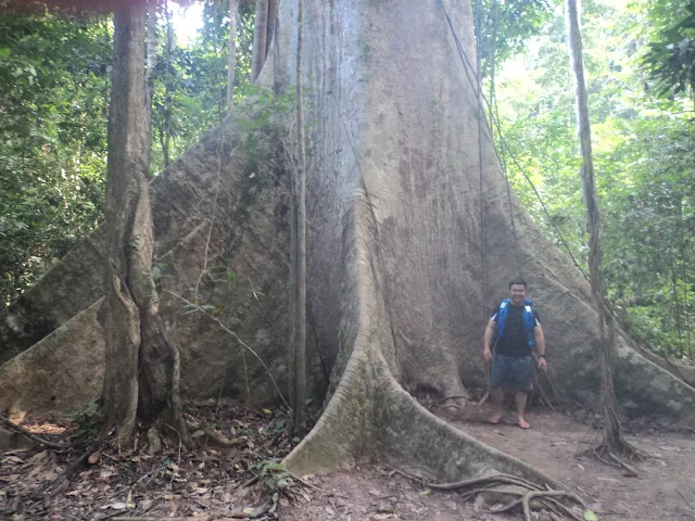 |
| Tualang(Tapang) Tree of Kuala Tahan National Park/瓜拉大汉国家公园的大甘巴豆树 |
 |
| Mahseer(Kelah) Sanctuary/吉罗鱼养殖场 |
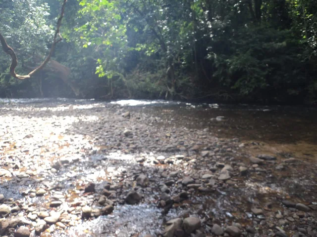 |
| Starting Point of Trekking to Lata Berkoh/柏谷瀑布徒步起点 |
Attractions:
i.Park Centre & Mini Market
ii.Kelah Square
-the mini aquarium of Malaysian Mahseer/Kelah of National Park.
iii.Tahan Hide
-the hide where can watching the salt licks that provided nutrients for animals that arrived by night walk.
iv.Terisek Hill/Bukit Terisek
-the hill about 344m high where can looking the Mount Tahan/Gunung Tahan.
v.Canopy Walkway
-one of the longest canopy walkways/tree top walks of Malaysia about 530m long.
vi.Tahan Jetty/Rapids Shooting
-the boat ride along the river rapids of Tembeling River where can visiting the Batek/Bateq tribe community village.
vii.Lata Berkoh Boat Ride
-the Tahan River boat ride where can visiting the Mahseer/Kelah Sanctuary & Lata Berkoh Waterfalls.
viii.Mount Tahan/Gunung Tahan(formerly known as Batu Relai)
-the highest peak of Peninsular Malaysia about 2187m high.
The Things Must Do:
1.Participating the Night Jungle Walk to search some wildlife & insects.
2.Learning about the flora & fauna of National Park.
3.Visiting the Terisek Hill/Bukit Terisek.
4.Walking across the Canopy Walkway.
5.Take a look the Jeram Panjang Rapids during the rapids shooting.
6.Learning the fire making skill & blowpipe shooting skill of Batek/Bateq tribe.
7.Enjoying the Lata Berkoh Boat Ride like watching the Tualang/Tapang Tree.
8.Feeding the Malaysian Mahseer/Kelah at Mahseer/Kelah Sanctuary.
Arrival Date
29,30 & 31 July 2017
*Maybe mistake in information.
Malay Name
Taman Negara Kuala Tahan
Location
Jerantut-Kuala Tahan Road(Route 1508)/Jalan Jerantut-Kuala Tahan,Kuala Tahan
Google Map GPS Coordinate(approximately)
4.383537, 102.401473
Opening Hours
Following to your activities
Opening Hours(Canopy Walkway)
9am-3pm,Closed on Friday
Tel for Guided Tours Services
09-2672131/019-9811241/019-9831241
Attention
1.Do not enter this area during rainy seasons.
2.The National Park must be arrived by boat.
3.This area must visit accompanied by guided tour.
4.You must following the instructions of tour guide while in activities.
5.Beware of poisonous snakes.
6.Do not stand & taking photo on the canopy walkway.
7.You will getting wet during Rapid Shooting Trip.
8.Lata Berkoh Boat Trip is opening according to weather conditions.
9.Visitors must have physically fit & good health for visiting this area.
10.Keeping the National Park clean.
11.Do not soak in the water while you are applied the sunscreen lotion.
12.Do not bath with soap, body shampoo & shampoo in here.
Entrance Fee
Below the RM5 per person(including the boat fee)
Below the RM10 per camera
*Some activities fees, please refer to the guided tour or park centre.
Fishing Permit Fee
Below the RM15 per rod
Entrance Fee(Canopy Walkway)
Below the RM10 per person
Lata Berkoh Boat Trip Fee
Above the RM100 per boat(Maximum Persons: Four Persons)
Mount Tahan Hiking Fee
Above the RM200 per one guide for 7 Days
Website
www.wildlife.gov.my/en/taman-negara-pahang-kuala-tahan
Website(Guided Tour Services)
www.tamannegara.my/v1
瓜拉大汉是以大汉河与淡贝岭河交界处(在马来文称为Kuala)来命名的拥有多间水上餐厅同时也以国家公园周围的观星活动区闻名的彭亨的国家公园的其中一个入口。设立于一九三九年的国家公园(前名为国王乔治五世国家公园)是坐落在中央森林脊椎内由马来西亚半岛野生动物与国家公园保护局(Jabatan Perlindungan Hidupan Liar & Taman Negara Semenanjung Malaysia/PERHILITAN)所管理的涵盖了彭亨、登嘉楼与吉兰丹部分地区的约四千三百四十三平方公里的马来西亚最大兼第一座国家公园,它也抚育了超过三千种植物品种如名为塔汉蒲葵(Tahan Serdang)的棕榈科植物等以及超过五百种动物品种如马来貘/亚洲貘/四不像/食梦兽、鼠鹿、马来亚虎(马来西亚国兽)、马来熊(全世界最小的熊类品种)与似野结鱼/马来西亚结鱼/吉罗鱼等。另外,国家公园也是拥有约七百三十米高如耳洞(Telinga Cave/Gua Telinga)的全马来西亚半岛最高的洞穴系统的约岁数超过一亿三千万年的全世界最古老的热带雨林之一。国家公园也是东盟遗产公园、国际自然保护联盟国家公园、生物多样性重点区域、重点鸟区与联合国教科文组织世界遗产暂定名单。树冠层吊桥/树冠层步道是原是用以在树冠层(森林最上层)上进行考察研究用途但现为旅游用途的行人步道。急流是河流较斜的部分形成河流变浅以及石头露出水面而空气泡混入水里形成白色水花。巴迪族(Batek/Bateq)是大多数居住在彭亨、吉兰丹与登嘉楼/丁加奴之间的国家公园内以游牧狩猎采集方式生活的马来西亚半岛原住民部落之一以及马来西亚半岛原住民是包含了塞芒人、仙奴伊人与原始马来人三个主要部落的原住民群体社群。似野结鱼/马来西亚结鱼/吉罗鱼是在到达成年期时会回到河流的上游来产卵的原生东南亚鱼类。热带雨林是位于北回归线(Tropic of Cancer/Northern Tropic)与南回归线(Tropic of Capricorn/Southern Tropic)之间的赤道地带内没有旱季、温度暖和与高雨水量的生态系统。全世界第一座国家公园是美国的黄石国家公园。位于国家公园旁就是设立于二零二三年的马来西亚及东南亚第一座老虎保护区苏丹阿都拉皇家老虎保留地。
景点:
i.公园中心与微型商店
ii.似野结鱼/马来西亚结鱼/吉罗鱼广场
-国家公园的似野结鱼/马来西亚结鱼/吉罗鱼的小型水族馆。
iii.大汉观景台
-以夜行徒步来到达的看见提供动物营养的盐沼的瞭望台。
iv.特勒锡山
-约三百四十四米高的可看见大汉山的山丘。
v.树冠层吊桥
-约五百三十米长的全马来西亚其中一条最长的树冠层吊桥之一。
vi.大汉码头/急流游船
-沿着淡贝岭河的急流上行走的可参观巴迪族(Batek/Bateq)部落村庄的游船服务。
vii.柏谷瀑布游船
-可参观似野结鱼/马来西亚结鱼/吉罗鱼养殖场与柏谷瀑布等的大汉河的游船服务。
viii.大汉山
-约两千一百八十七米高的马来西亚半岛最高峰。
一定要做的事:
1.参与夜行徒步活动去寻找野生动物与昆虫。
2.了解国家公园的动植物。
3.参观特勒锡山。
4.在树冠层吊桥上行走。
5.在急流游船中观赏班让急流(Jeram Panjang)。
6.了解巴迪族(Batek/Bateq)部落的生火技术与吹管箭射击技术。
7.享受柏谷瀑布游船例如观看大甘巴豆树。
8.在似野结鱼/马来西亚结鱼/吉罗鱼养殖场喂食似野结鱼/马来西亚结鱼/吉罗鱼。
到访日期
二零一七年七月二十九日、三十日与三十一日
*资讯可能有错误。
马来名称
Taman Negara Kuala Tahan
位置
瓜拉大汉而连突-瓜拉大汉路(一五零八号公路)/Jalan Jerantut-Kuala Tahan,Kuala Tahan
谷哥地图导览座标(估计性)
入门票
一个人马币低过五令吉(包括船费在内)
一架照相机低过十令吉
*一些活动费需向导览团队或公园中心询问。
钓鱼准证费
一支鱼竿低过十五令吉
树冠层吊桥入门票
一个人马币低过十令吉
柏谷瀑布游船船费
一艘船马币高过一百令吉(最高人数为四个人)
大汉山登山费
一位向导七天马币高过两百令吉
网址
www.wildlife.gov.my/en/taman-negara-pahang-kuala-tahan
导览服务网址
www.tamannegara.my/v1
Location Map/位置图:
Government Clinics/政府诊所:
1.Kuala Tahan Health Clinic(Klinik Kesihatan)/瓜拉大汉政府诊所
Google Map GPS Coordinate(approximately)/谷哥地图导览座标(估计性): 4.382222, 102.401528
Food in Kuala Tahan/瓜拉大汉美食:
1.Kuala Tahan Health Clinic(Klinik Kesihatan)/瓜拉大汉政府诊所
Google Map GPS Coordinate(approximately)/谷哥地图导览座标(估计性): 4.382222, 102.401528
Food in Kuala Tahan/瓜拉大汉美食:
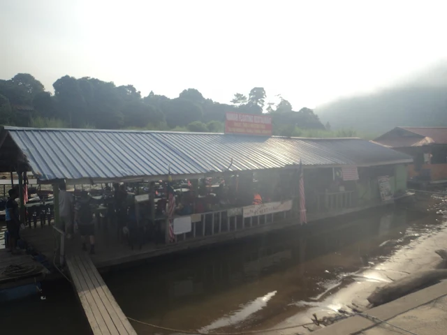
Mawar 水上餐厅
Location/位置: Kuala Tahan Jetty/Jeti Kuala Tahan,Kuala Tahan
Location Map/位置图:
END
结束
You can also visited/你也可到访:
Kuantan & Pekan/关丹与北根
Website/网址:Click here/请按这里
Lanchang/联增
Website/网址:Click here/请按这里
Gohtong Jaya & Genting Highlands/梧桐再也与云顶高原
Website/网址:Click here/请按这里
Raub/劳勿
Website/网址:Click here/请按这里
Website/网址:Click here/请按这里
Bentong & Janda Baik/文冬与贞德拜
Website/网址:Click here/请按这里
Bukit Tinggi/武吉丁宜
Website/网址:Click here/请按这里
Temerloh & Triang(Teriang)/淡马鲁与直凉
Website/网址:Click here/请按这里
Kuala Lipis & Benta/立卑与文打(文达)
Website/网址:Click here/请按这里
Kuala Rompin & Tioman Island(Pulau Tioman)/瓜拉云冰与刁曼岛
Website/网址:Click here/请按这里
Fraser's Hill(Bukit Fraser)/福隆港
Website/网址:Click here/请按这里
Jerantut & National Park(Taman Negara)/而连突与国家公园
Website/网址:Click here/请按这里
Maran & Gambang/马兰与甘孟
Website/网址:Click here/请按这里
Cameron Highlands/金马伦高原(金马仑高原)
Website/网址:Click here/请按这里
Bentong & Janda Baik/文冬与贞德拜
Website/网址:Click here/请按这里
Bukit Tinggi/武吉丁宜
Website/网址:Click here/请按这里
Website/网址:Click here/请按这里
Kuala Lipis & Benta/立卑与文打(文达)
Website/网址:Click here/请按这里
Kuala Rompin & Tioman Island(Pulau Tioman)/瓜拉云冰与刁曼岛
Website/网址:Click here/请按这里
Fraser's Hill(Bukit Fraser)/福隆港
Website/网址:Click here/请按这里
Jerantut & National Park(Taman Negara)/而连突与国家公园
Website/网址:Click here/请按这里
Maran & Gambang/马兰与甘孟
Website/网址:Click here/请按这里
Cameron Highlands/金马伦高原(金马仑高原)
Website/网址:Click here/请按这里
Sungai Lembing/林明
Website/网址:Click here/请按这里
Accommmodations near Jerantut & National Park(Taman Negara)/而连突与国家公园附近住宿:
*The hotel that listed below only for consideration.
*以下酒店只供参考。
Luxury Hotel/豪华酒店:
Mutiara Taman Negara Eco Park Resort=609-2662200
Location/位置: Kuala Tahan National Park/Taman Negara Kuala Tahan
Price/价钱: Above the RM200/马币两百令吉以上
Budget Hotel/廉价酒店:
Yellow Guest House=017-9463357/09-2664243
Location/位置: Sungai Deli Road/Jalan Sungai Deli,Kuala Tahan
Price/价钱: From RM90 to RM150/马币九十令吉至一百五十令吉之间
Distance/距离:
*The distances show at below are only approximate.
*以下只是大概距离。
K.L.I.A.-Kota Gelanggi Caves Heritage Park=250km
吉隆坡国际机场-哥打哥朗宜洞遗产公园=两百五十公里
Sultan Ahmad Shah Airport-Kuala Tahan National Park=211km
苏丹阿末沙机场-瓜拉大汉国家公园=两百一十一公里
Kota Gelanggi Caves Heritage Park-Kuala Tahan National Park=68.1km
哥打哥朗宜洞遗产公园-瓜拉大汉国家公园=六十八点一公里
Itinerary of Jerantut & National Park(Taman Negara) based on my suggestion/我本身建议的而连突与国家公园的旅程:
Days that I suggest to travel in here/我本身建议在这里游玩的时间=3 Days/三天
Must Visit Attractions/必游景点:
1.Kota Gelanggi Caves Heritage Park/哥打哥朗宜洞遗产公园
2.Kuala Tahan National Park/瓜拉大汉国家公园
First Day/第一天(departure from K.L.I.A. or Sultan Ahmad Shah Airport/从吉隆坡国际机场或苏丹阿末沙机场出发):
*According to guided tour.
*依据导览团队而定。
Second Day/第二天:
*According to guided tour.
*依据导览团队而定。
Third Day/第三天:
*According to guided tour.
*依据导览团队而定。
End of the Trip
旅程结束